Alabama Faces Enhanced Risk Tornadoes, Strong Winds, Large Hail, and Flash Flooding From Tuscaloosa and Birmingham Through Montgomery and Grove Hill Wednesday Into Thursday Morning
ALABAMA — A dangerous and multi-hazard severe weather outbreak is unfolding across Alabama on Wednesday, May 6, 2026, with an Enhanced Risk Level 3 of 5 in place from Tuscaloosa and Birmingham southward through Montgomery and Grove Hill. The threat includes tornadoes, strong straight-line winds, large hail, and flash flooding, with the severe weather window running from early this afternoon through the late night hours and storms slowly weakening after 2:00 AM.
The Timing Window for Alabama Wednesday
The severe weather threat is unfolding in three distinct timing zones across the state:
| Timing | Zone |
|---|---|
| 1:00 PM to 7:00 PM | Northern Alabama including Florence, Huntsville, and Decatur |
| 3:00 PM to Midnight | Central Alabama including Birmingham, Tuscaloosa, Montgomery, and Talladega |
| 10:00 PM to 6:00 AM | Southern Alabama including Greenville, Troy, and areas toward Mobile |
The Enhanced Risk Zone — Highest Tornado Threat
The Enhanced Risk Level 3 of 5 covers the core of Alabama’s most dangerous zone today, stretching from Tuscaloosa and Birmingham in the north down through Montgomery, Greenville, and Grove Hill in the south. This is where the highest tornado probability is concentrated.
The Storm Prediction Center has placed much of Alabama under a SIG1 hatched area, indicating that a strong tornado rated EF-2 or higher is possible within the outlined zone. This is part of the conditional intensity group messaging now used by the SPC.
Tornado Probability Across Alabama
The tornado outlook valid until 7:00 AM CDT Thursday May 7 shows the following probability zones across Alabama:
| Zone | Tornado Probability Within 25 Miles |
|---|---|
| Core Enhanced Risk area — Tuscaloosa, Birmingham, Montgomery | 15 to 29 percent |
| Surrounding Slight Risk area | 5 to 14 percent |
| Outer Marginal zone | 2 to 4 percent |
Full Hazard List for Today and Tonight
Residents across the Enhanced Risk zone should prepare for all of the following:
- Tornadoes — strong EF-2 possible within the SIG1 hatched area
- Strong straight-line damaging winds
- Large hail from a few storms
- Heavy rain and flash flooding
Flash Flood Watch in Effect for Central Alabama
A Flash Flood Watch is in effect for most of Central Alabama as heavy rainfall accompanies the storm system through this evening. Rain and storms are already moving through the western half of the Tennessee Valley at midday, which is limiting instability and the overall severe thunderstorm threat in far northern Alabama. However, heavy rain and flooding remain the main concern for far North Alabama through this evening regardless of the storm threat.
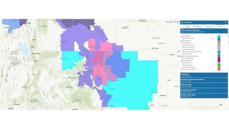
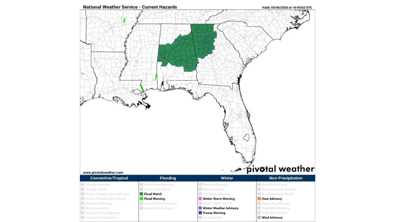
Current Hazards in Effect
The National Weather Service current hazards map valid May 6, 2026 at 16:40 UTC shows a broad Flood Watch covering much of Alabama and portions of Tennessee and Georgia, confirming the widespread flooding concern accompanying today’s severe weather outbreak.
What Alabama Residents Must Do Now
Anyone across Tuscaloosa, Birmingham, Montgomery, Greenville, Grove Hill, Talladega, Auburn, and the surrounding communities must have a reliable way to receive warnings today. The severe weather window opens early this afternoon and does not end until the overnight hours.
- Have multiple ways to receive warnings including a weather app, TV, and weather radio
- Know your shelter location before storms arrive
- Do not wait for a tornado to be visible before taking shelter
- Avoid flood-prone roads and low-lying areas through tonight
Stay with CabarrusWeekly.com for continuing live updates on Alabama’s severe weather and flooding threat through Thursday morning.