Indiana, Illinois, and Ohio Face Incoming Line of Storms With 40 MPH Gusts and Heavy Downpours as Timing Nowcast Tracks Afternoon Arrival on Memorial Day Weekend
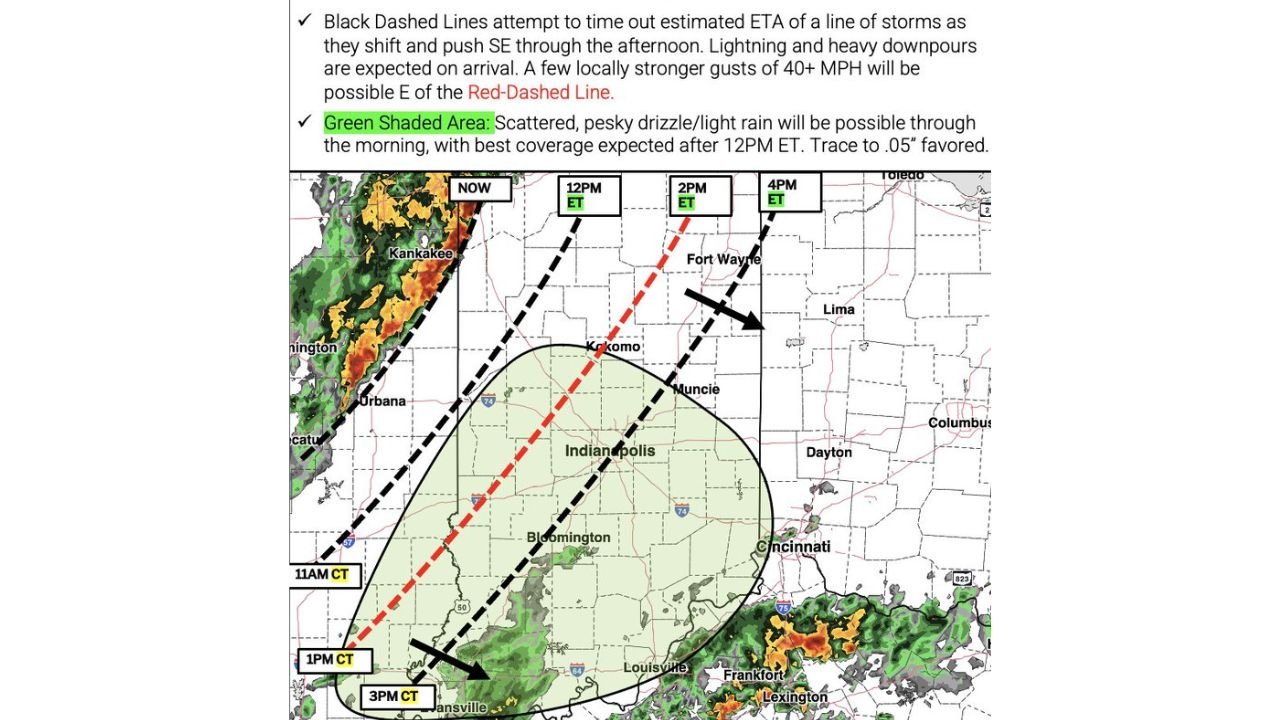
INDIANA, ILLINOIS, AND OHIO — A line of storms is pushing southeast across the region on Sunday May 24, 2026, bringing lightning, heavy downpours, and locally gusty winds exceeding 40 MPH to portions of Indiana, Illinois, and Ohio through the afternoon hours, with timing tracked as of 9:50 AM ET.
Exact Storm Arrival Times by Location
The nowcast map breaks down the estimated arrival of the storm line as it pushes southeast through the afternoon.
Storm line ETA by area:
| Time | Zone | Areas Affected |
|---|---|---|
| Now | Western Illinois | Kankakee, Urbana corridor |
| 11:00 AM CT | Southern Illinois | Approaching Evansville area |
| 12:00 PM ET | Northern Indiana | Kokomo, Fort Wayne corridor |
| 1:00 PM CT | Southern Illinois / Indiana border | Evansville area |
| 2:00 PM ET | Central Indiana | Indianapolis, Muncie corridor |
| 3:00 PM CT | Far Southern Illinois | Moving toward Kentucky border |
| 4:00 PM ET | Eastern Indiana / Western Ohio | Fort Wayne east toward Lima, Dayton |
What the Storm Line Will Bring on Arrival
This is not a light rain event. When the storm line arrives, conditions will deteriorate quickly.
Hazards expected with storm arrival:
- Lightning with every storm cell along the line
- Heavy downpours capable of reducing visibility rapidly
- Locally gusty winds of 40 MPH or stronger east of the red-dashed line on the nowcast map
- Rapid onset with little warning time once the line approaches
The strongest wind gusts above 40 MPH are focused on areas east of the red-dashed line, which cuts through central Indiana from the Kokomo area southward.
Scattered Drizzle and Light Rain Already Affecting Central Indiana
Ahead of the main storm line, a separate concern exists for a broad area covering Indianapolis and surrounding communities.
Green shaded zone details:
| Detail | Information |
|---|---|
| Coverage Area | Indianapolis metro and surrounding region |
| Precipitation Type | Scattered drizzle and light rain |
| Timing | Through the morning hours |
| Best Coverage Window | After 12:00 PM ET |
| Expected Accumulation | Trace to 0.05 inches |
This light rain and drizzle will not be the headline event but will make outdoor conditions uncomfortable well ahead of the main storm line arriving later in the afternoon.
Holiday Weekend Outdoor Plans Directly Impacted
Anyone at outdoor events, cookouts, or track activities across Indiana, Illinois, and Ohio on Sunday faces a challenging afternoon.
What to plan for:
- Morning hours bring scattered drizzle across central Indiana
- Afternoon hours bring the main storm line with lightning and heavy rain
- Dry windows will be limited and difficult to time precisely
- 40 MPH wind gusts make outdoor setups and tents a risk east of the storm line
- Postponing outdoor activities until after the storm line clears is advisable where possible
Storm Line Pushes Toward Ohio Through the Evening
The storm system continues tracking southeast, meaning areas across western and central Ohio including Dayton, Lima, and the Columbus corridor will see the line arrive during the mid to late afternoon hours ET. Communities further southeast toward Cincinnati, Lexington, and Frankfort will be monitoring conditions into the evening hours as the line continues its push.
Stay with CabarrusWeekly.com for continuing updates on storm timing and conditions across Indiana, Illinois, and Ohio this Memorial Day weekend.