Florida Drought Relief Incoming as Deep Tropical Moisture Targets the State Next Week With 2 to 4 Inches Widespread and Isolated Totals Possibly Exceeding 10 to 12 Inches
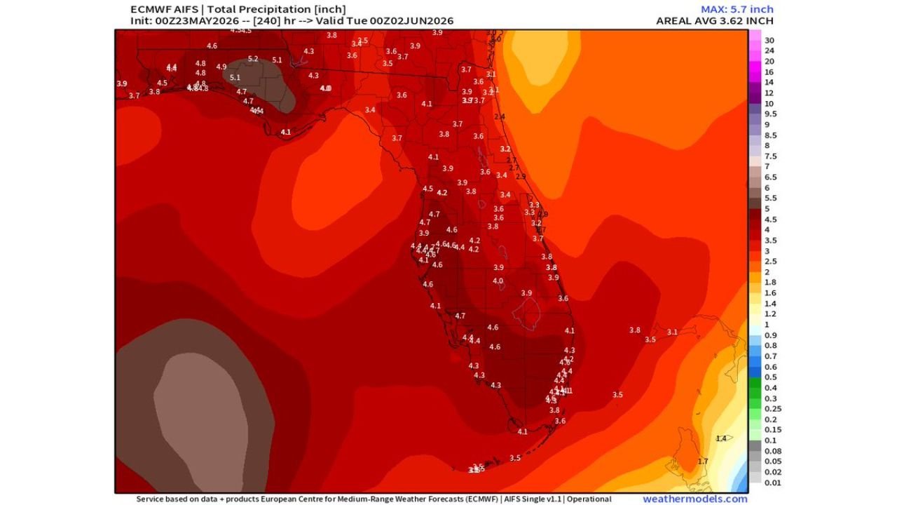
FLORIDA — Significant drought relief is on the way for Florida as a plume of deep tropical moisture is forecast to move across the state during the second half of next week, bringing multiple rounds of beneficial rainfall to a state currently experiencing its worst drought in over 25 years. The ECMWF model initialized at 00z May 23, 2026, valid through Tuesday June 2, 2026, shows widespread totals of 2 to 4 inches with an areal average of 3.62 inches and a maximum value of 5.7 inches across the 240-hour period.
What the ECMWF Model Is Showing Across Florida
The total precipitation forecast covering the next 10 days paints a dramatically wet picture for the entire state.
Forecast rainfall totals by region:
| Region | Forecast Total |
|---|---|
| Northwest Florida / Panhandle | 4.4 to 5.2 inches |
| Northeast Florida | 3.6 to 4.3 inches |
| North Central Florida | 3.7 to 4.8 inches |
| Central Florida | 3.4 to 4.7 inches |
| Tampa Bay area | 3.8 to 4.6 inches |
| Southwest Florida | 4.1 to 4.7 inches |
| Southeast Florida | 3.1 to 3.9 inches |
| South Florida / Keys area | 3.5 to 4.4 inches |
| Areal Average Statewide | 3.62 inches |
| Maximum Value | 5.7 inches |
These are model-derived totals and represent widespread coverage across virtually the entire state with no region left dry over the 10-day window.
Why This Event Matters So Much for Florida
Florida is currently dealing with the worst drought conditions in over 25 years. The combination of a prolonged dry pattern and above normal temperatures heading into summer has pushed soil moisture deficits to critical levels across much of the state.
Why this rainfall event is significant:
- Multiple rounds of rain spread across several days allow better soil absorption
- Widespread 2 to 4 inch totals address the deficit across all regions simultaneously
- Deep tropical moisture brings higher rain rates and better coverage than typical frontal systems
- Second half of next week timing gives soils a chance to prepare before peak summer heat arrives
- Worst drought in 25 years means even heavy rainfall will be largely absorbed before flooding becomes a concern
Isolated Totals Could Reach 10 to 12 Inches in Some Spots
While the widespread forecast sits at 2 to 4 inches, forecasters are flagging the potential for isolated locations to pick up 10 to 12 inches over the 10-day period. This is a critical distinction.
Rainfall range breakdown:
| Scenario | Expected Total |
|---|---|
| Widespread coverage | 2 to 4 inches |
| Above average spots | 4 to 6 inches |
| Isolated maximum locations | 10 to 12 inches possible |
| Model maximum value | 5.7 inches (ECMWF) |
Forecasters are clear that too much rain at once is not a good thing even during a drought. Flooding remains a real concern if the heaviest totals concentrate over a short period in localized areas, and residents should remain aware that drought relief and flood risk can coexist during high-rainfall tropical moisture events.
Tropical Development Potential Remains Extremely Low
The moisture plume driving this rainfall event is being monitored for any signs of tropical development. Forecasters are currently assigning an extremely low probability to any organized tropical development associated with this system.
Tropical development status:
- Tropical development probability: Extremely low at this time
- Even if something were to form: It would function primarily as a rain-maker only
- First name on the Atlantic list: Arthur
- No tropical storm or hurricane threat currently anticipated with this moisture surge
The primary story here is rainfall and drought relief, not tropical weather.
What Florida Residents Should Watch For
With the event still several days away, the forecast will continue to be refined through the week ahead.
- Monitor forecasts daily as the moisture plume approaches later next week
- Drought relief is the primary outcome but localized flooding is possible where totals cluster
- Outdoor plans for late next week should account for repeated shower and storm chances
- No severe tropical threat is expected but the pattern warrants continued monitoring
- Next outlook update will refine timing and coverage as the system draws closer
Stay with CabarrusWeekly.com for continuing updates on Florida’s drought relief forecast and the incoming tropical moisture event through the end of May and into June.