Western Plains, Eastern New Mexico, and Southwest Texas Emerge as Primary Storm Chaser Targets for May 26 Through June 5 as Omega Block and Deep Moisture Set Up Significant Chase Window
WESTERN UNITED STATES — A strong omega-like blocking pattern combined with deep moisture returning across the entire High Plains is setting up what storm chasers are eyeing as a significant chase window from May 26 through June 5, 2026. The Western Plains carry the highest confidence for active severe weather during this period, though pinning down the exact target area within that broad zone remains the central challenge heading into the chase season.
Three Potential Target Zones Identified for the Chase Window
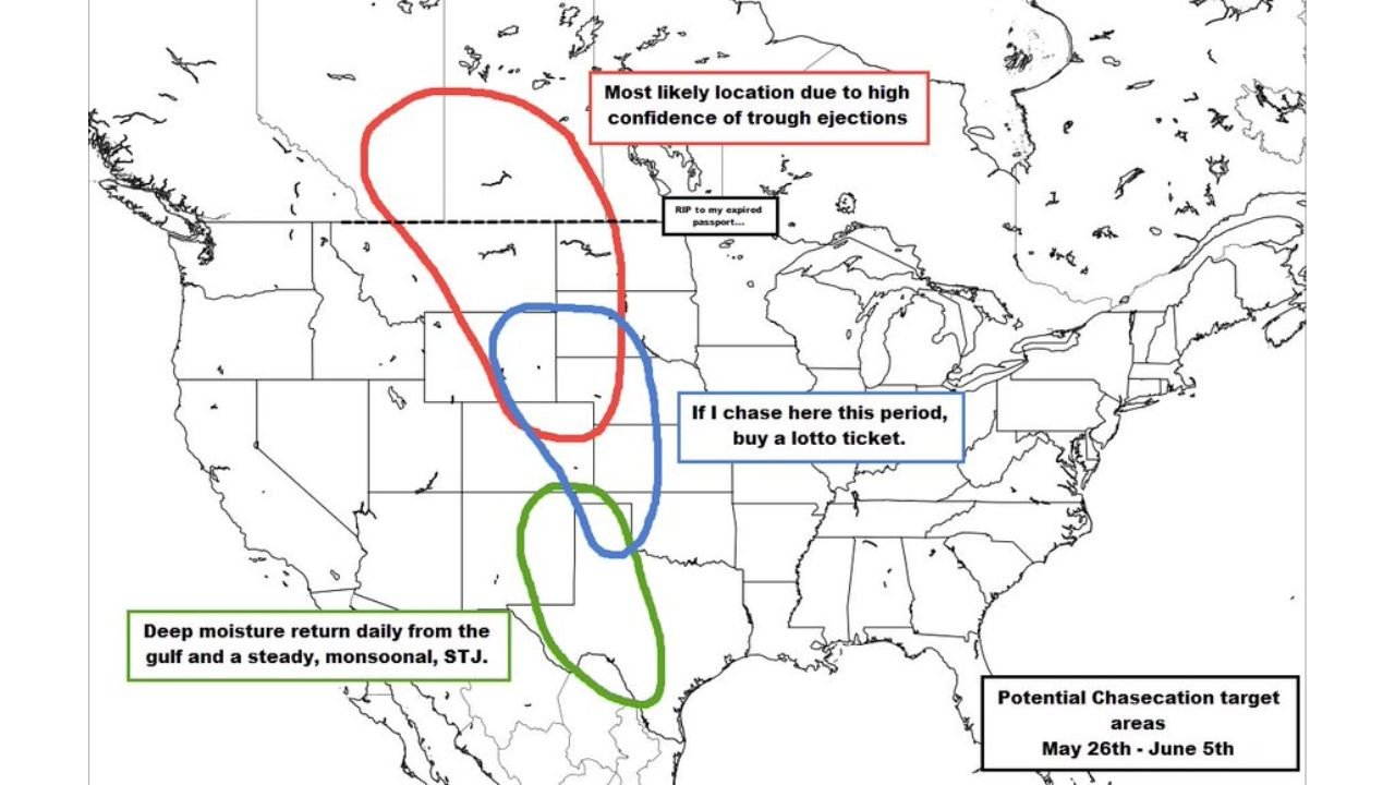
The outlook map breaks down the potential chasecation target areas into three distinct zones with varying confidence levels.
Target zone breakdown May 26 through June 5:
| Zone | Color | Location | Confidence | Reasoning |
|---|---|---|---|---|
| Primary | Red | Northern Western Plains | High | Trough ejections and strong flow overlapping moisture |
| Secondary | Blue | Central High Plains | Low | Lucky scenario only, described as lotto ticket odds |
| Tertiary | Green | Eastern New Mexico / Southwest Texas | Moderate | Deep Gulf moisture return daily, steady monsoonal STJ |
Northern Western Plains Holds the Highest Confidence
The northern portion of the Western Plains is circled in red on the target map and identified as the most likely location due to high confidence in trough ejections during the chase window. The combination of multiple days of trough ejections and strong flow overlapping with deep moisture creates favorable conditions for organized and significant storm activity.
Why the northern zone leads confidence:
- Multiple trough ejection events expected over several days
- Strong atmospheric flow overlapping with deep moisture return
- Several consecutive days of potential storm activity rather than a single event
- Omega block pattern helping to anchor the setup in place rather than washing it out quickly
Eastern New Mexico and Southwest Texas Offer a Secondary Opportunity
The green zone covering Eastern New Mexico and Southwest Texas represents a secondary target area driven by a different atmospheric mechanism. This region is being watched for a Clovis-type event, powered by the Sub-Tropical Jet stream and deep Gulf moisture returning on a daily basis in a steady, monsoonal pattern.
Eastern New Mexico and Southwest Texas setup:
- Deep moisture return daily from the Gulf of Mexico
- Steady monsoonal Sub-Tropical Jet providing lift and organization
- Clovis-esque event potential referencing a historically significant storm type for the region
- Independent of the northern trough ejection setup, making it a separate viable target
The Central High Plains Wildcard
The blue zone centered on the Central High Plains carries the lowest confidence of the three target areas. Forecasters describe the probability of a significant chase event in this zone during the period as so unlikely that hitting it would be lottery ticket odds.
If conditions do align favorably across the central zone, the potential exists for very large mesoscale convective events, but that outcome is firmly in the category of best case scenario rather than a reliable forecast.
What the Omega Block Means for This Setup
An omega-like blocking pattern is a large-scale atmospheric configuration where the jet stream buckles into a shape resembling the Greek letter omega. This type of block is significant for storm chasers because:
- It anchors weather systems in place for extended periods rather than moving them quickly through
- Deep moisture can return repeatedly to the same region under a persistent block
- Multiple chase days become possible rather than a single isolated event
- Storm organization improves when the large-scale pattern remains locked in place
The Forecast Challenge Heading Into the Window
Despite the high confidence that the Western Plains will be active, the specific day-to-day targets within that broad region remain difficult to pin down this far in advance. The difference between the northern plains and the central high plains as the active zone on any given day could span hundreds of miles, making early positioning decisions critical and uncertain.
The window from May 26 through June 5 will be watched closely as model guidance improves and the omega block pattern begins to come into sharper focus over the coming days.
Stay with CabarrusWeekly.com for continuing updates on severe weather setups and storm potential across the Western Plains through the end of May and into early June.