1 to 2 Feet of Snow and 70 MPH Gusts Slam New England Coast — Long Island, Cape Cod and Providence Buried as Nor’easter Continues
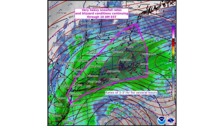
NEW ENGLAND — A ferocious Nor’easter continues to hammer the Northeast coastline with 1 to 2 feet of snow already reported in many areas and wind gusts reaching 70 mph along the coast, creating whiteout conditions and widespread disruption from New Jersey through Massachusetts.
Snow is still falling and blowing hard as the powerful offshore low churns east of the Mid-Atlantic, with some of the highest totals concentrated along Long Island, southeastern Massachusetts, Cape Cod, and parts of Rhode Island.
Snow Totals Climb Past 20 Inches in Coastal Zones
Updated snowfall analyses show a swath of extreme accumulation stretching from central and eastern Long Island across coastal Connecticut and Rhode Island into eastern Massachusetts.
Notable totals include:
- 24 to 26 inches across portions of Long Island
- 22 to 25 inches in parts of southeastern Massachusetts
- 24 inches near Providence, Rhode Island
- 20+ inches across portions of coastal New Jersey
- Widespread 15–20 inch totals inland from Philadelphia to eastern Connecticut
Areas farther inland, including parts of upstate New York and western Pennsylvania, have generally seen lower totals in the 3–8 inch range, highlighting how tightly focused the heaviest snow band remains along the coast.
70 MPH Coastal Gusts Fuel Blizzard Conditions
Wind gusts near 70 mph have been reported along exposed coastal locations, especially near Cape Cod, Nantucket, and eastern Massachusetts shorelines.
Those powerful winds are:
- Producing blizzard conditions
- Drifting snow across highways
- Causing near-zero visibility at times
- Increasing the risk of coastal impacts
With the storm still offshore and deepening earlier in the event cycle, strong winds have combined with heavy snowfall rates to create extremely dangerous travel conditions.
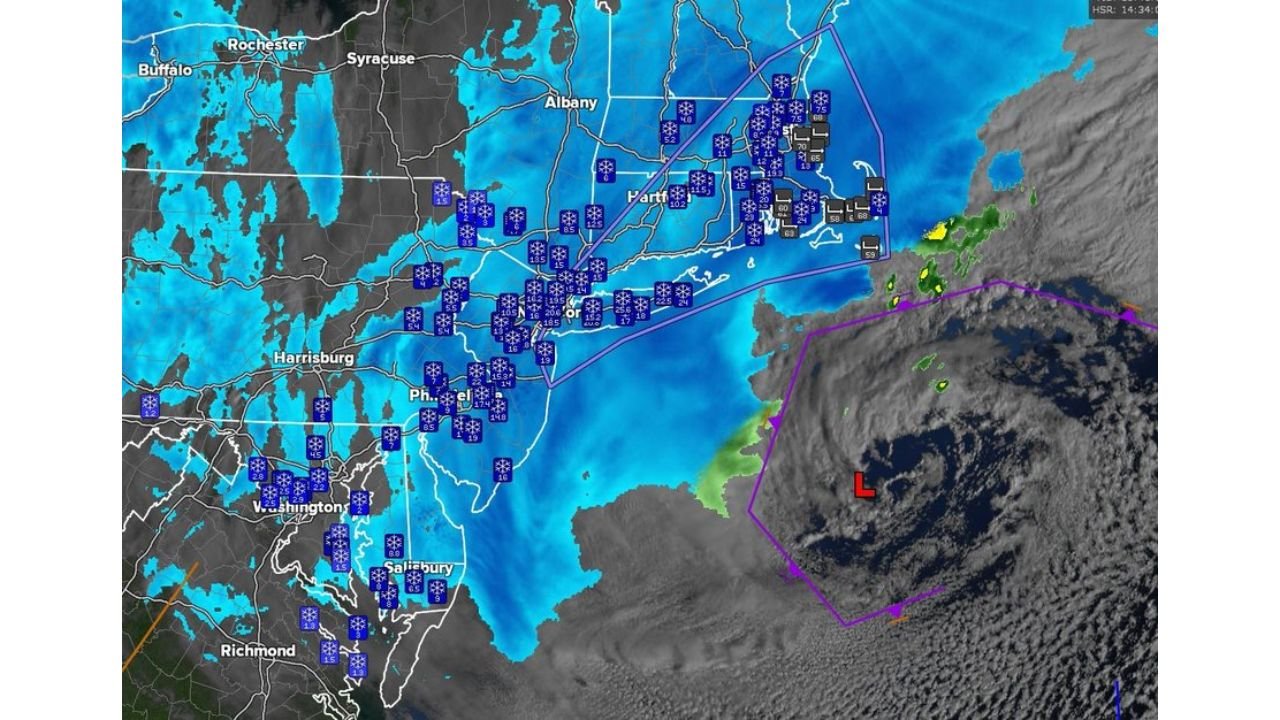
Radar Shows Persistent Heavy Bands from New Jersey to Massachusetts
Satellite and radar imagery depict an expansive shield of snow stretching from Virginia and Maryland north through New Jersey, New York City, Long Island, and into Massachusetts.
The heaviest bands continue pivoting near:
- Providence
- Boston metro
- Long Island’s south shore
- Cape Cod and Nantucket
As long as these bands remain anchored, snowfall rates of 1–3 inches per hour remain possible in localized areas.
What This Means for Cabarrus County
Although this powerful Nor’easter is centered well to the north, large East Coast storms can temporarily reshape the broader weather pattern.
For Cabarrus County:
- No direct snowfall impacts are expected.
- Cooler air may filter south behind the departing system.
- Breezy conditions are possible as the pressure gradient shifts.
The Carolinas often feel secondary effects from strong Atlantic cyclones, particularly through brief cool-downs or increased winds once the storm exits.
A High-Impact Coastal Blizzard Still in Progress
With 1 to 2 feet of snow already measured in multiple communities and coastal gusts pushing 70 mph, this Nor’easter ranks among the more intense coastal snowstorms of the season.
Travel remains hazardous across parts of New Jersey, Long Island, Rhode Island, and Massachusetts, especially near the coastline where drifting and blowing snow persist.
Cabarrus Weekly will continue monitoring any downstream weather changes that could affect North Carolina.
Stay with CabarrusWeekly.com for continuing weather coverage and local updates.