11 Tornadoes, 20 Hail Reports Across Oklahoma and Kansas as Uncertain 700mb Forcing Shaped March 5 Severe Weather
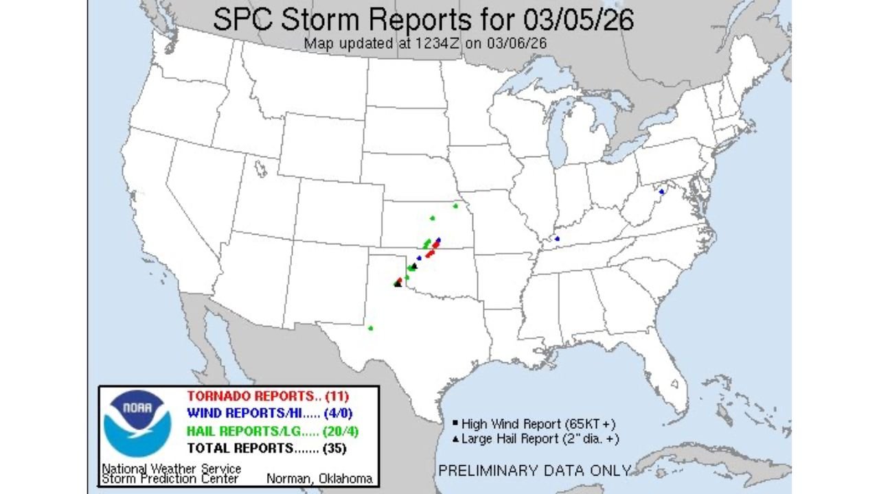
OKLAHOMA — Preliminary Storm Prediction Center data confirms that 11 tornado reports, 20 hail reports, and 4 damaging wind reports were logged on March 5, with the majority of activity concentrated across western and central Oklahoma into southern Kansas.
While the setup had been described as conditional ahead of time, the final storm reports show that several supercells were able to organize and produce meaningful impacts.
Where the Reports Occurred
The SPC storm report map shows a tight clustering of severe weather reports from:
- Southwest Oklahoma near Altus
- Northward through Elk City
- Into central Oklahoma
- Extending into portions of southern Kansas
Most tornado and large hail reports were concentrated along a southwest-to-northeast corridor, consistent with discrete supercell development ahead of a larger forcing mechanism.
Outside of the Plains cluster, only a few isolated severe reports appeared across parts of the Midwest and Mid-Atlantic, emphasizing how focused the event was geographically.
The Role of 700mb Forcing
Forecast discussions following the event point to 700mb wave forcing as a key factor in how storms evolved.
Mid-level waves at 700mb can:
- Enhance localized lift
- Trigger storm development earlier than expected
- Influence storm spacing and structure
However, these features are notoriously difficult to forecast with precision.
Storm evolution tied to 700mb forcing often introduces uncertainty in:
- Storm timing
- Storm coverage
- Whether storms remain discrete or merge into clusters
In this case, storms fired in a corridor where forcing aligned with instability and wind shear, allowing several tornado-producing supercells to develop despite broader uncertainty in coverage.
Why CAMs Often Struggle
Convective Allowing Models (CAMs) frequently respond aggressively to subtle mid-level waves. Sometimes they over-initiate convection; other times they miss isolated storm development entirely.
The March 5 event serves as a reminder that:
- Conditional setups can still produce significant tornadoes
- Mid-level forcing can alter storm outcomes quickly
- Forecast confidence may hinge on small-scale atmospheric features
Lessons Moving Forward
Even when a severe weather setup appears uncertain, the presence of strong shear and instability means any storm that forms can become impactful.
The confirmed totals:
- 11 Tornado Reports
- 20 Hail Reports
- 4 Wind Reports
- 35 Total Severe Reports
highlight how focused supercell development can produce meaningful severe weather within a relatively narrow corridor.
As spring severe season continues across the Plains, forecasters will remain cautious when mid-level wave forcing is present — especially in environments already supportive of rotating storms.
CabarrusWeekly.com will continue analyzing major severe weather events and breaking down the meteorological factors behind them.