1,200-Mile Rainfall Corridor Targets Texas to Ohio Valley with 3–5+ Inches Over Next 10 Days, Threatening Flooding and Delaying Eastern Grain Belt Planting
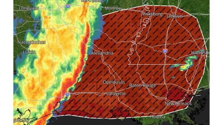
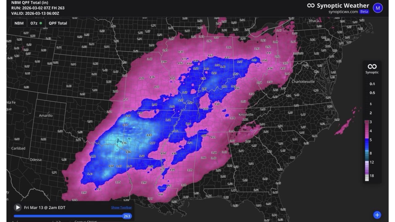
TENNESSEE VALLEY — A prolonged and unusually expansive rainfall pattern is setting up across the central and eastern United States, with forecast guidance indicating a 1,200-mile swath of 3 inches or more and a 900-mile corridor of 5 inches or greater rainfall totals over the next 10 days.
This type of widespread, high-end precipitation signal in early March is not typical and could significantly impact agriculture across the Eastern grain belt.
3+ Inches Stretching from Texas to the Ohio Valley
Ensemble rainfall projections show a broad zone of 3 inches or more extending from:
Central and eastern Texas
Across Arkansas and northern Louisiana
Through Mississippi and western Tennessee
Into Kentucky, southern Illinois, southern Indiana and Ohio
This corridor spans roughly 1,200 miles, forming a continuous band of above-normal precipitation totals.
Major cities within or near this swath include:
Dallas and Tyler, Texas
Little Rock, Arkansas
Memphis and Nashville, Tennessee
Louisville, Kentucky
Evansville, Indiana
Cincinnati, Ohio
Such a large, uninterrupted precipitation axis suggests multiple storm systems tracking along a similar path.
5+ Inches Focused from East Texas Through Tennessee
Embedded within the broader rain shield is a concentrated 900-mile corridor where totals exceed 5 inches, with some localized areas approaching 6 to 7 inches.
The heaviest accumulations are projected across:
East Texas
Northern Louisiana
Central and eastern Arkansas
Western and central Tennessee
Western Kentucky
Some ensemble members indicate pockets exceeding 6 inches in portions of east Texas and Arkansas, with widespread 5-inch totals extending northeastward into parts of Kentucky and southern Illinois.
Eastern Grain Belt Faces Planting Delays
The Eastern grain belt, including portions of:
Kentucky
Southern Indiana
Southern Illinois
Ohio
is positioned directly within the 3–5 inch rainfall zone.
Early March soil saturation from repeated rain events can delay field preparation and planting schedules. With rainfall projected over a 10-day window, soils may struggle to drain between systems.
Excessive rainfall during this period increases the risk of:
Field flooding
Standing water in low-lying agricultural areas
Delayed machinery access
Flooding and River Concerns
With rainfall totals accumulating over multiple days, attention will also turn to river basins across the Lower Mississippi Valley and Tennessee Valley.
Watersheds that may see elevated runoff include:
Arkansas River Basin
Red River Basin
Tennessee River Basin
Lower Ohio River Basin
Repeated rainfall events over saturated ground can enhance runoff efficiency, raising the risk of localized flooding and river rises.
Why This Setup Is Unusual for Early March
While spring is known for active weather patterns, the scale of this rainfall projection stands out.
A 1,200-mile continuous corridor of 3+ inches and a 900-mile zone of 5+ inches suggests:
A persistent storm track
Strong moisture transport from the Gulf of Mexico
Multiple low-pressure systems moving along a similar path
Such alignment often indicates a sustained trough pattern anchored over the central United States.
What to Watch Over the Next 10 Days
Residents across Texas, Louisiana, Arkansas, Mississippi, Tennessee, Kentucky, Illinois, Indiana and Ohio should monitor updated forecasts closely.
While exact totals may shift, the signal for widespread, heavy rainfall is strong. Areas already prone to flooding or with poor drainage could experience elevated impacts.
For agricultural regions, early planning adjustments may be necessary if repeated rainfall events verify as projected.
If you are located within the projected heavy rainfall corridor and begin experiencing rising water or saturated ground conditions, share your observations with CabarrusWeekly.com as we continue monitoring this expansive early-March rainfall event.