193 Records on the Line as a Massive Heat Wave Locks In Over the Eastern United States This Week — Florida Faces Widespread 90s With Feels-Like Temperatures Hitting 120 Degrees by Saturday
FLORIDA, EASTERN UNITED STATES — A massive heat wave is descending on the eastern United States this week, and the numbers are staggering. 193 forecast records are projected to be tied, broken, or come close as high pressure locks in and refuses to move. Florida sits squarely in the bullseye of this event, with widespread 90s expected across the state and some spots pushing into the upper 90s by Saturday April 18 — with heat index values making it feel like 120 degrees in the worst of it.
This Is Not a Typical April Warm Spell
This is a full-scale heat wave arriving well ahead of summer. High pressure is staying locked in over the eastern United States, acting as a heat dome that traps warm air and drives temperatures to levels more typical of late July than mid-April. The first official day of summer is not until June 21 — yet the eastern U.S. is about to experience summer at its most brutal, weeks early.
Across the full week, 193 forecast records are in play — records that could be tied, broken, or approached across the eastern United States as this heat wave builds and peaks.
Record Potential by Day — Eastern United States
The record-breaking potential builds dramatically through the week before peaking mid-week and remaining elevated through the weekend.
| Date | Day | Records — Hi Max (Break/Tie or Near) |
|---|---|---|
| April 12 | Sunday | 5 break / 6 tie |
| April 13 | Monday | 1 break / 0 tie |
| April 14 | Tuesday | 14 break / 14 tie |
| April 15 | Wednesday | 46 break / 12 tie — Peak Day |
| April 16 | Thursday | 24 break / 8 tie |
| April 17 | Friday | 17 break / 19 tie |
| April 18 | Saturday | 18 break / 9 tie |
Wednesday April 15 is the single most dangerous day of this heat wave from a record-breaking standpoint, with 46 records projected to break and 12 more to tie across the eastern United States in a single 24-hour period. That is an extraordinary number of records falling on one day and signals just how anomalous this heat event is for mid-April.
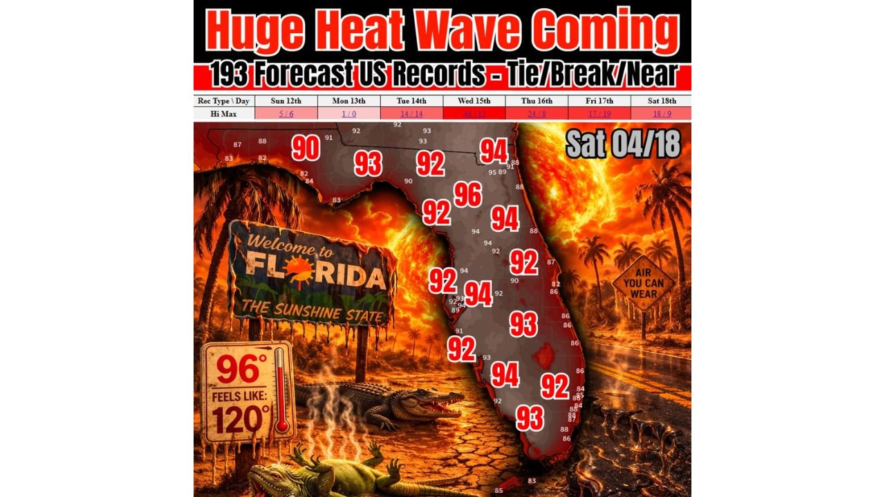
Florida on Saturday April 18 — The Numbers Are Alarming
While the record peak hits Wednesday, Florida’s most intense heat arrives by Saturday April 18, when the combination of high temperatures and oppressive humidity creates life-threatening conditions. The forecast temperatures mapped across Florida for Saturday paint a brutal picture.
| Region of Florida | Saturday April 18 Forecast High |
|---|---|
| North Florida | 90 to 93°F |
| North Central Florida | 92 to 93°F |
| Central Florida interior | 92 to 96°F |
| Orlando and surrounding area | 94 to 96°F |
| Tampa Bay area | 92 to 94°F |
| Southwest Florida | 92 to 94°F |
| South Florida interior | 93 to 94°F |
| Southeast Florida coast | 86 to 88°F |
| East Central Florida coast | 87 to 88°F |
Central Florida bears the worst of Saturday’s heat, with temperatures reaching 96 degrees in interior locations. The coastal areas offer modest relief in comparison — but even the coast is running in the mid to upper 80s, well above normal for mid-April.
Feels Like 120 Degrees — The Heat Index Danger
Raw temperatures alone do not tell the full story of what this heat wave will feel like on the ground in Florida. When humidity is factored in, the apparent temperature — what the human body actually experiences — reaches a genuinely dangerous level.
96 degrees with Florida’s humidity produces a feels-like temperature of 120 degrees. That is not uncomfortable. That is dangerous to anyone exposed to it, particularly the elderly, children, outdoor workers, and anyone without access to air conditioning. Heat exhaustion and heat stroke become serious risks at these heat index values, and prolonged outdoor exposure becomes life-threatening.
What High Pressure Locking In Means for the Week
The mechanism driving this heat wave is straightforward and stubborn. High pressure is staying locked in over the eastern United States throughout the week, creating a heat dome effect that prevents cooler air from breaking through and traps heat at the surface. There is no significant cold front or pattern change capable of ending this event in the immediate forecast period.
That means the heat is not a one or two day event — it builds from Sunday through Wednesday’s record peak and then remains elevated through Saturday, giving Florida and the broader eastern U.S. a prolonged exposure to dangerous heat through the entire week.
Heat Safety for Florida and the Eastern United States This Week
With 193 records potentially falling and heat index values approaching 120 degrees in Florida, heat safety this week is not optional — it is critical.
- Limit outdoor activity during peak heating hours from late morning through late afternoon
- Never leave children or pets in vehicles — interior car temperatures in this heat can become fatal within minutes
- Hydrate aggressively — drink water before you feel thirsty, especially if working or exercising outdoors
- Know the signs of heat exhaustion and heat stroke — dizziness, nausea, confusion, and stopping sweating are all emergency warning signs
- Check on elderly neighbors and family members who may not have adequate access to cooling
- Use cooling centers if air conditioning is unavailable at home
The Week at a Glance — Eastern U.S. Heat Wave
| Factor | Details |
|---|---|
| Total records at risk | 193 — tie, break, or near-record |
| Peak record day | Wednesday April 15 — 46 breaks, 12 ties |
| Florida peak heat day | Saturday April 18 |
| Highest forecast temp in Florida | 96°F — Central Florida interior |
| Feels-like temperature | Up to 120°F |
| Heat driver | High pressure locked in over eastern U.S. |
| Summer’s official start | June 21 — weeks away |
193 Records and 120-Degree Heat Index — This Week Is Historic
The numbers define what is coming. 193 forecast records across the eastern United States. Forty-six records potentially breaking on a single Wednesday in April. Widespread 90s and upper 90s across Florida by Saturday. A heat index hitting 120 degrees. All of this arriving weeks before the official start of summer, driven by high pressure that is not going anywhere.
Florida and the eastern United States need to take this week seriously. This is not normal April warmth — this is a historic heat event arriving at the wrong time of year, and the record books are about to show it.
Stay with CabarrusWeekly.com for daily heat wave coverage, record temperature tracking, and heat safety updates across Florida and the eastern United States throughout this dangerous week.