2026 Tornado Season Surges Above Average Across Texas, Mississippi, Alabama and Southeast as Early March Outbreaks Push Reports Past 235
NORTH CAROLINA — Severe weather activity across the United States has accelerated rapidly in 2026, with tornado reports now running above average following multiple outbreaks in early to mid-March.
Tornado Reports Climb Above Seasonal Average
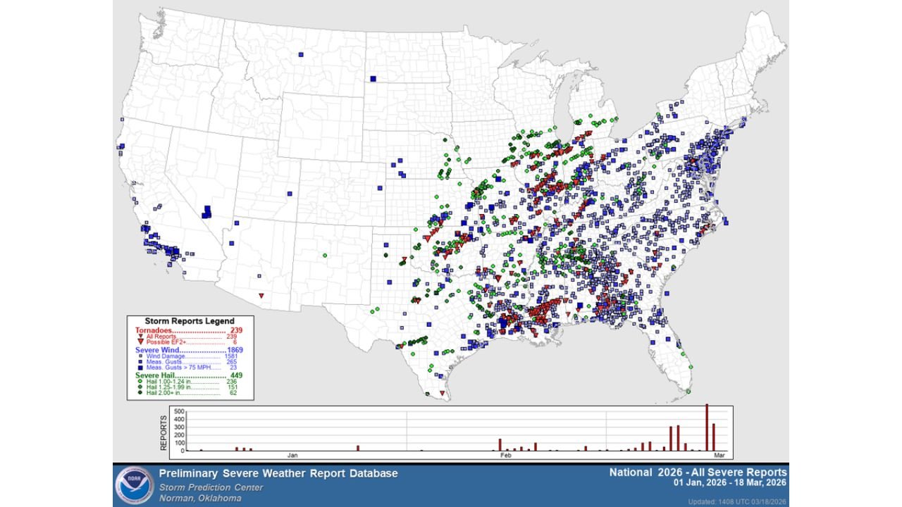
Latest data shows that at least 235 tornado reports have been recorded so far in 2026, placing this year above the historical average for mid-March.
The trend line indicates a noticeable uptick in activity compared to many recent years, especially following a series of organized severe weather outbreaks across the South and Midwest.
Climatologically, tornado activity begins increasing in March, but the current pace suggests a more active-than-normal start to the season.
Southeast and Southern Plains Lead Activity
The majority of tornado reports have been concentrated across:
- Texas and Oklahoma: Early-season storm systems triggering multiple tornado events
- Louisiana, Mississippi, and Alabama: Repeated outbreaks with clustered reports
- Arkansas and Tennessee: Active severe weather corridors extending northeast
- Georgia and the Carolinas: Expanding severe weather footprint into the Southeast
Storm report mapping shows dense clusters of tornado activity across the Deep South and lower Mississippi Valley, highlighting the primary storm track so far this year.
Severe Weather Reports Extend Beyond Tornadoes
In addition to tornadoes, the broader severe weather pattern has produced a significant number of:
- Severe wind reports, including damaging straight-line winds
- Large hail events, particularly across Texas and the central Plains
These reports indicate a highly active severe weather environment, not limited to tornadoes alone but encompassing multiple hazards.
March Outbreaks Driving the Spike
The sharp increase in tornado reports is largely tied to recent early-to-mid March severe weather outbreaks, which have significantly boosted seasonal totals.
These outbreaks featured strong atmospheric instability, wind shear, and moisture return from the Gulf, creating favorable conditions for tornado development across multiple states.
The result has been a rapid jump in report counts over a short period, pushing 2026 above the long-term average line.
What This Means for the Rest of Spring
With tornado activity already running above average, attention now turns to the peak months of April, May, and June, when severe weather typically intensifies further.
If current trends continue, the U.S. could see a very active spring severe weather season, especially across the central Plains, Mississippi Valley, and Southeast.
For North Carolina, this is particularly important, as the state often sees increased severe weather risk during spring transitions when storm systems track eastward.
Growing Concern as Peak Season Approaches
The early-season surge in tornado reports serves as a warning sign that atmospheric conditions are already supportive of severe weather.
With 235 tornado reports already logged, the combination of warm temperatures, increasing moisture, and active storm systems suggests that the coming weeks could remain volatile.
As outlined in the official CabarrusWeekly.com format guidelines , this evolving severe weather pattern will be closely monitored for further outbreaks and regional impacts.
Stay with CabarrusWeekly.com for continued coverage, and share what conditions you are seeing in your area as the 2026 severe weather season continues to unfold.