7:50 AM Radar to Evening Clear-Out: Widespread Arkansas Rain Sweeps From Texarkana to Jonesboro With Calm Conditions Ahead
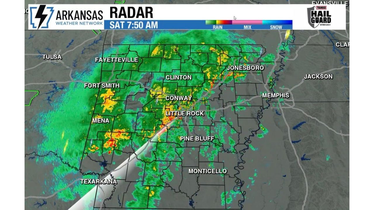
ARKANSAS — A steady and much-needed round of rainfall is spreading across the state this morning, with radar showing widespread precipitation already impacting cities from Texarkana and Mena to Little Rock, Conway, Jonesboro, and Fort Smith, as the system gradually tracks east through the day.
Morning Radar Shows Widespread Rainfall Across Key Cities
As of early morning, radar imagery highlights:
- Moderate to heavy rain bands stretching from southwest Arkansas into central regions
- Heavier pockets near Mena, Texarkana, and western counties
- Steady rain continuing through Little Rock, Conway, and into northeast Arkansas including Jonesboro
- Lighter but persistent rainfall extending toward eastern parts of the state
This setup confirms that most of Arkansas is experiencing rain, with coverage broad and consistent rather than isolated.
Rain Continues Eastward Through the Day
The system is expected to progress east across Arkansas throughout the day, gradually shifting heavier rainfall toward eastern counties while western areas begin to dry out.
- Western Arkansas (Fort Smith, Mena): Improving conditions later today
- Central Arkansas (Little Rock, Conway): Steady rain through midday
- Eastern Arkansas (Jonesboro, Delta region): Rain continues into the afternoon
This eastward movement suggests a full-state impact window, with nearly all regions seeing measurable rainfall before the system exits.
Severe Weather Risk Remains Extremely Low
Despite widespread rain, the overall setup is not supportive of severe weather development.
- No organized severe storms expected
- Thunderstorm activity remains limited and non-severe
- Main impacts are rainfall and occasional heavier downpours
While radar continues to be monitored closely, the environment lacks the instability needed for significant severe weather.
Clear-Out Expected Later This Evening
As the system exits to the east:
- Rain will gradually taper off from west to east
- Skies are expected to clear later this evening statewide
- Overnight conditions should become calmer and drier
This marks a clean transition from a wet start to a more settled evening across Arkansas.
Much-Needed Rainfall Brings Relief
This event is being viewed as a positive rainfall event, especially for areas needing moisture.
- Rainfall is widespread and beneficial
- No major flooding concerns indicated in the current setup
- Provides a temporary break from dry conditions
While not severe, the system is delivering valuable precipitation across multiple regions.
Stay Updated With Cabarrus Weekly
For continued updates on rainfall trends, radar developments, and upcoming weather changes across Arkansas and beyond, stay connected with Cabarrus Weekly—your trusted source for clear, data-driven weather coverage.