Washington and Oregon Face Major Pattern Flip as Pacific Northwest Trough Brings Back Mountain Snow and Lower Snow Levels
PACIFIC NORTHWEST — A significant atmospheric pattern shift is taking shape that could restore mountain snow and lower snow levels across Washington and Oregon after a stretch of less favorable conditions.
Forecast guidance shows a pronounced upper-level trough digging into the western United States, replacing the prior ridge-dominated setup and opening the door for colder air and active storm tracks.
Upper-Level Trough Anchors Over the Western United States
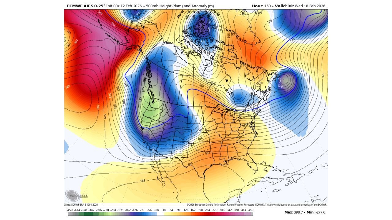
500mb height anomaly projections highlight a deep trough settling over Washington, Oregon, and extending into northern California and the Great Basin. This configuration favors cooler-than-normal temperatures aloft and a more direct Pacific storm pathway into the Cascades.
As the jet stream dips southward, it enhances lift and moisture transport into the Washington Cascades, Oregon Cascades, and northern Rockies, key ingredients for sustained mountain snowfall.
Mountain Snowpack Building Likely in the Weeks Ahead
With colder air returning aloft and storm systems tracking through the region, mountain snow accumulation is expected to increase, particularly across:
• Western Washington mountain ranges
• Northern and central Oregon Cascades
• Portions of northern Idaho and western Montana
While seasonal deficits may not be fully erased, this shift could significantly improve snowpack trends heading toward late winter.
Lower Snow Levels Return to Washington and Oregon
The trough pattern also supports lower snow levels, increasing the likelihood that snow falls at elevations below typical mid-winter averages across both states.
Lowland snow remains possible in this type of setup, but widespread, region-wide events become more difficult later in the season due to increasing daylight and marginal surface temperatures.
Localized lowland snow scenarios will depend heavily on storm timing, intensity, and surface temperature profiles.
Broader Pattern: Western Cool, Eastern Mild
The large-scale anomaly map shows ridging across the eastern United States while the West sits under persistent troughing. This contrast reinforces:
• Cooler, unsettled conditions across Washington and Oregon
• Warmer-than-normal trends across parts of the Southeast and Mid-Atlantic
Such a pattern favors repeated storm impulses into the Pacific Northwest over a multi-week period.
Bottom Line
A notable pattern reversal is developing for Washington and Oregon, with a strong upper-level trough bringing back mountain snow and lowering snow levels across both states. While widespread lowland snow remains uncertain, the return of colder air and a more active storm track should help rebuild snowpack through the coming weeks.
Residents across Washington and Oregon should monitor updated forecasts as individual storm systems become better defined.
If you’re seeing snow levels drop or fresh accumulation in your local mountains, share your observations with us at CabarrusWeekly.com.