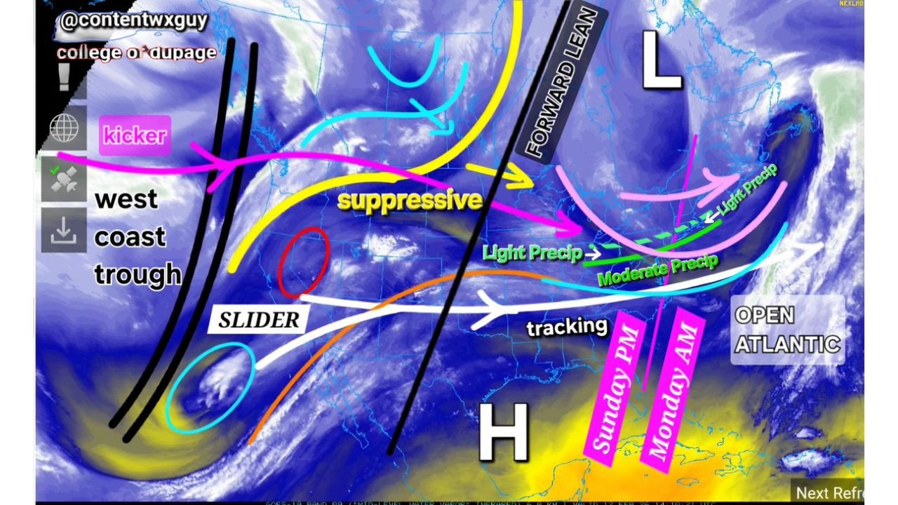
Virginia, Maryland, Delaware and Southern New England Could See “Slider” System Track Through Lower Mid-Atlantic Late Sunday Into Monday
MID-ATLANTIC — A developing “slider” system may track along the lower Mid-Atlantic late Sunday into early Monday, bringing a band of precipitation from Virginia into Maryland and possibly brushing southern New England.
While the setup is still several days away, early signals suggest modest north or south shifts in the storm track remain possible.
West Coast Trough Sets the Stage
The broader atmospheric pattern shows a trough positioned along the West Coast, helping to dislodge energy eastward. As that energy transfers downstream, it promotes a flatter, more suppressive flow across the eastern United States.
This configuration favors a fast-moving, lower-latitude storm track, commonly referred to as a “slider,” rather than a deep coastal nor’easter.
Track Focused on the Lower Mid-Atlantic
Current projections show the disturbance sliding from the Tennessee Valley toward the Mid-Atlantic coastline late Sunday.
States most likely to see impacts include:
• Virginia
• Maryland
• Delaware
• Southern New Jersey
Depending on the exact track, precipitation could extend northward into eastern Pennsylvania, New York City, and southern New England, potentially grazing coastal Connecticut, Rhode Island, and southeastern Massachusetts.
Light to Moderate Precipitation Most Likely
At this stage, precipitation appears primarily light to moderate in intensity, especially across central and eastern Virginia into Maryland.
Areas farther north into the Upper Mid-Atlantic and southern New England may see lighter precipitation if the northern edge of the precipitation shield expands.
Because the system is expected to remain somewhat suppressed, widespread heavy precipitation appears less likely under the current configuration.
Timing: Late Sunday Through Early Monday
The main window for precipitation currently appears to be Sunday afternoon through early Monday morning, with the most organized band passing overnight.
Surface high pressure to the south and east may limit northward moisture expansion, reinforcing the idea of a narrower precipitation shield.
Still 4 to 5 Days Out: Track Adjustments Possible
With roughly four to five days before the event, modest adjustments in storm track remain possible.
A slight northward shift would bring steadier precipitation into the Upper Mid-Atlantic and southern New England. A more suppressed track would keep the heaviest precipitation confined to Virginia and southern Maryland.
Bottom Line
A slider-type system is projected to move along the lower Mid-Atlantic late Sunday into Monday, bringing light to moderate precipitation to Virginia, Maryland, and Delaware, with a chance of grazing southern New England coastal areas.
Forecast refinements are expected over the coming days as models narrow down the exact storm path.
If you’re in the Mid-Atlantic or southern New England and begin to see changing conditions Sunday, share your local reports with us at CabarrusWeekly.com.