New Jersey Snow Signal Grows as ECMWF Shows Potential Foot-Plus Storm, But Ensemble Spread Urges Caution
NEW JERSEY — A recent ECMWF operational model run has drawn attention for depicting over a foot of snowfall across parts of New Jersey, but ensemble comparisons show that solution may be on the aggressive side compared to the broader guidance envelope.
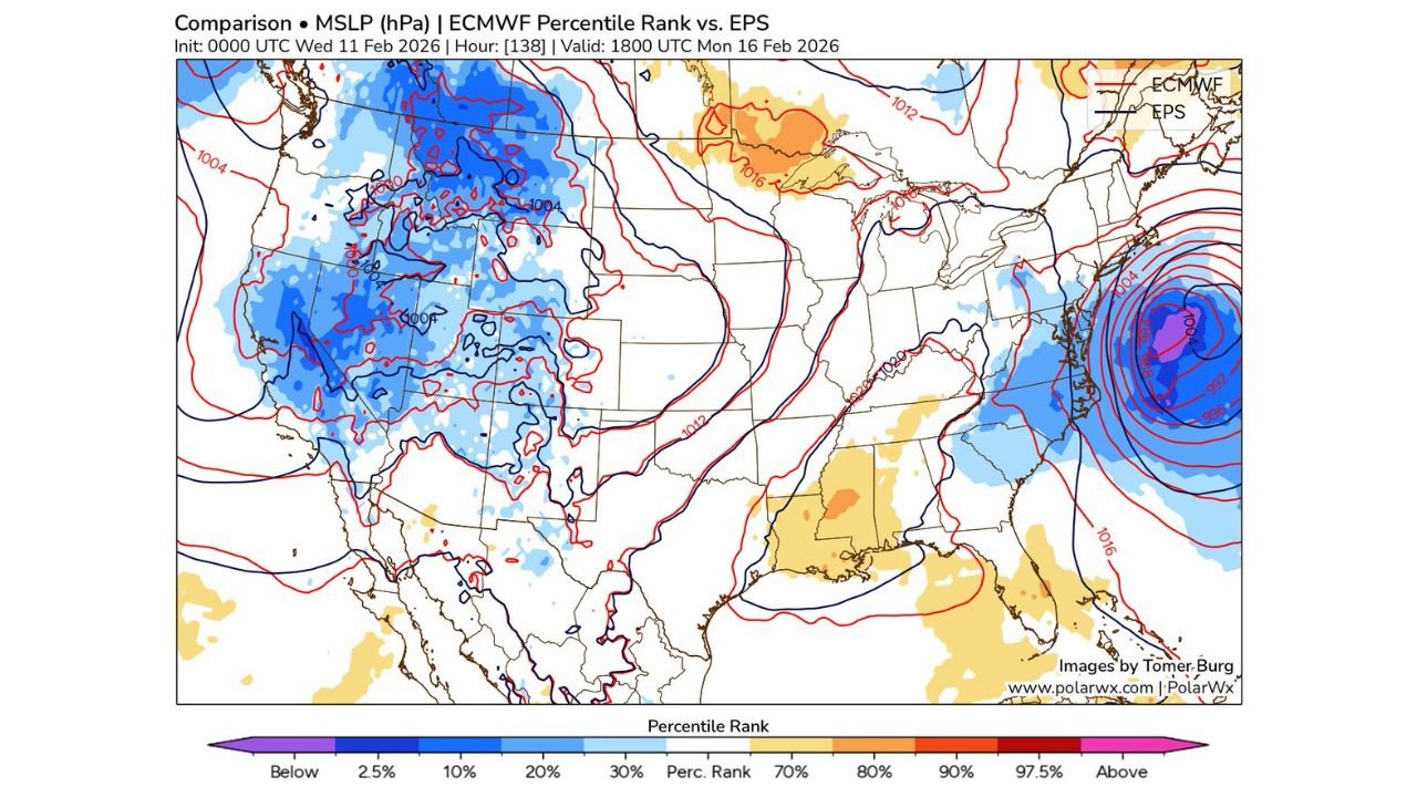
While the 0z ECMWF run stands out, it is not entirely unsupported within the ensemble cluster.
ECMWF Operational Run: Strong Coastal Low Near New Jersey
The comparison map of mean sea-level pressure shows a deep coastal low positioned just offshore of the Mid-Atlantic, with tightly packed isobars near New Jersey, eastern Pennsylvania, New York City, and southern New England.
Such a track would favor significant snowfall across:
• Central and northern New Jersey
• Eastern Pennsylvania
• New York City metro
• Southern New England coastal areas
The operational depiction suggests a strong, well-organized storm with a classic heavy snow setup west and northwest of the low track.
EPS Ensemble Members: More Spread, Less Extreme
When comparing the ECMWF operational run to the broader EPS (Ensemble Prediction System) members, the percentile rank analysis indicates that the deterministic solution ranks high relative to many ensemble members.
In other words, it is on the stronger side of the distribution — but not completely detached from the ensemble signal.
Some ensemble members still support a notable coastal system, though many depict:
• A slightly weaker surface low
• A track a bit farther offshore
• More moderate snowfall totals
This is why the run is described as an outlier — but not a total outlier.
Western and Central U.S. Pattern Still Influential
Upstream, the broader hemispheric pattern shows a trough across the western United States and ridging tendencies downstream in parts of the East. Subtle adjustments in that western energy will ultimately determine:
• How quickly the coastal low deepens
• How far north the precipitation shield expands
• Whether New Jersey sits in the heaviest band
Small shifts in upper-level timing can dramatically alter snowfall placement in coastal storm setups.
Key Uncertainties Still in Play
At this lead time, several factors remain uncertain:
• Exact storm track relative to the New Jersey coastline
• Strength of coastal frontogenesis
• Boundary layer temperatures near the shore
A 50–100 mile shift east or west could significantly change totals for coastal New Jersey versus inland areas.
Bottom Line
The 0z ECMWF run showing over a foot of snow in New Jersey is stronger than many ensemble members but remains within the broader envelope of possibilities. While the signal for a coastal storm exists, confidence in exact snowfall totals remains limited due to ensemble spread.
Residents across New Jersey, eastern Pennsylvania, and the New York City metro should monitor upcoming model trends as guidance converges in the coming days.
If winter weather discussions are heating up in your area, share your local observations and forecasts with us at CabarrusWeekly.com.