Slow-Moving Nor’easter Dumps 13–14 Inches in Southeast Massachusetts as Coastal Low Crawls Offshore
SOUTHEAST MASSACHUSETTS — A classic late-winter nor’easter is crawling up the East Coast, already delivering 13 to 14 inches of snow across parts of southeast Massachusetts, with additional accumulation possible as the storm continues to slowly pivot offshore.
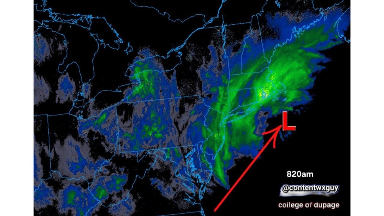
Radar imagery shows a well-defined coastal low parked just east of southern New England, with bands of moderate to heavy snow wrapping inland across Massachusetts, Rhode Island, Connecticut, and portions of eastern New York.
Coastal Low Crawling, Not Racing
Unlike fast-moving winter systems, this storm is moving at a sluggish pace. The low-pressure center remains offshore but close enough to maintain steady onshore flow and continuous snowfall.
The radar presentation highlights:
- A tight low-pressure circulation southeast of Massachusetts
- Heavy snow bands arcing inland across southeastern Massachusetts
- Broader precipitation shield extending into Connecticut and upstate New York
The storm’s slow movement is allowing snowfall totals to steadily climb rather than ending quickly.
Southeast Massachusetts Taking the Brunt
Southeast Massachusetts has been positioned beneath persistent snow bands, leading to impressive totals early in the day.
Measured amounts so far:
- 13–14 inches reported in SE Massachusetts
- Snow continuing with hours of daylight remaining
If the system continues to crawl as expected, additional accumulation could push totals even higher before tapering.
Broader Impacts Across Southern New England
While southeast Massachusetts is at the center of the heaviest snowfall, surrounding areas are also experiencing steady precipitation:
- Rhode Island
- Eastern Connecticut
- Portions of upstate New York
- Coastal New Hampshire
The heaviest radar returns remain concentrated near and just west of the offshore low, where banding is most persistent.
Why Slow Storms Mean Bigger Totals
When a coastal low stalls or moves slowly:
- Snow bands redevelop repeatedly over the same areas
- Accumulation rates stay consistent
- Totals climb even without extreme snowfall intensity
This type of setup is often referred to as a “classic” nor’easter because of the prolonged nature of snowfall and tight coastal circulation.
Travel and Safety Concerns
With snow still falling and the storm crawling along:
- Road conditions remain snow-covered and slippery
- Visibility may drop under heavier bands
- Plowing operations could struggle to keep pace
Residents are encouraged to limit travel if possible and monitor local advisories as the system continues to evolve.
Forecasters will continue tracking the offshore low and any shifts in banding that could increase totals in additional areas.
Stay with CabarrusWeekly.com for continued updates as this slow-moving winter storm unfolds across southern New England.