Strong Storms Target Mississippi and Alabama With Large Hail and 50 MPH Wind Gusts; Heavy Rainfall Up to 2 Inches Reported in Spots
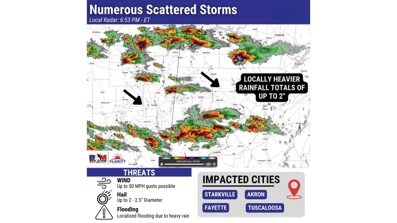
MISSISSIPPI & ALABAMA — Numerous scattered thunderstorms moved across parts of Mississippi and Alabama this evening, with several storms reaching strong to locally severe levels. Radar imagery shows clusters of intense cells producing large hail, gusty winds, and pockets of heavy rainfall.
While tornado risk has not been the primary concern, this event highlights how impactful storms can still become — particularly when hail and wind are involved.
Radar Shows Numerous Scattered Storms Across the Region
Evening radar indicated multiple strong storm cores stretching across central and northern Mississippi into western and central Alabama. The strongest cells displayed deep red and purple reflectivity signatures, consistent with intense updrafts capable of producing severe weather.
Communities near and around the following cities were within the more active storm corridor:
• Starkville
• Akron
• Fayette
• Tuscaloosa
Storm clusters were also visible near Birmingham and surrounding areas, with heavy rainfall embedded within the broader storm complex.
Primary Threats: Wind, Hail and Localized Flooding
Forecast guidance and radar analysis point to several key hazards:
• Wind gusts up to 50 MPH
• Hail up to 2 to 2.5 inches in diameter
• Localized flooding from heavier rainfall
Hail of that size is capable of damaging vehicles, roofs, and vegetation. Even without a prominent tornado setup, strong upper-level energy and steep lapse rates can support large hail production in discrete storm cells.
Heavy Rainfall Totals in Stronger Cells
Some of the more persistent storm clusters have produced locally heavier rainfall totals of up to 2 inches. When storms repeatedly track over the same areas, short-term flooding can develop, particularly in low-lying or poor drainage locations.
Urban areas such as Tuscaloosa and nearby communities could see brief street flooding where rainfall rates intensify.
Why Large Hail Can Occur Without High Tornado Risk
This event serves as a good example of how severe weather does not always require a high tornado threat to cause impacts.
Strong mid-level winds and robust storm updrafts can:
• Suspend hailstones in the upper levels of the storm
• Allow them to grow larger before falling
• Produce significant hail even in lower-tornado-risk environments
That dynamic appears to be playing out in portions of Mississippi and Alabama this evening.
What This Means for North Carolina
While this storm activity is occurring well to our southwest, active patterns across the Deep South can sometimes translate eastward over time. For Cabarrus County and the broader North Carolina region, it’s another reminder that early March is a transition period where severe storm setups begin to increase across the Southeast.
We will continue monitoring regional storm trends and provide updates if similar dynamics begin to shift toward the Carolinas.
If you have family or friends in the impacted areas of Mississippi or Alabama, encourage them to stay weather-aware this evening as strong storms continue moving through.
For the latest updates and regional weather developments, keep checking CabarrusWeekly.com.