Colorado Snow Talk Heats Up: Denver Likely to See Snow Next Week, But Big “Blizzard” Claims Appear Overstated for Now
COLORADO — Talk of a “big snowstorm” in the Denver metro next week is spreading quickly online, but the latest ensemble data suggests a more measured outlook.
Yes, snow is likely in the Denver area between Tuesday and Saturday of next week. However, declaring a major snowstorm this far out remains premature.
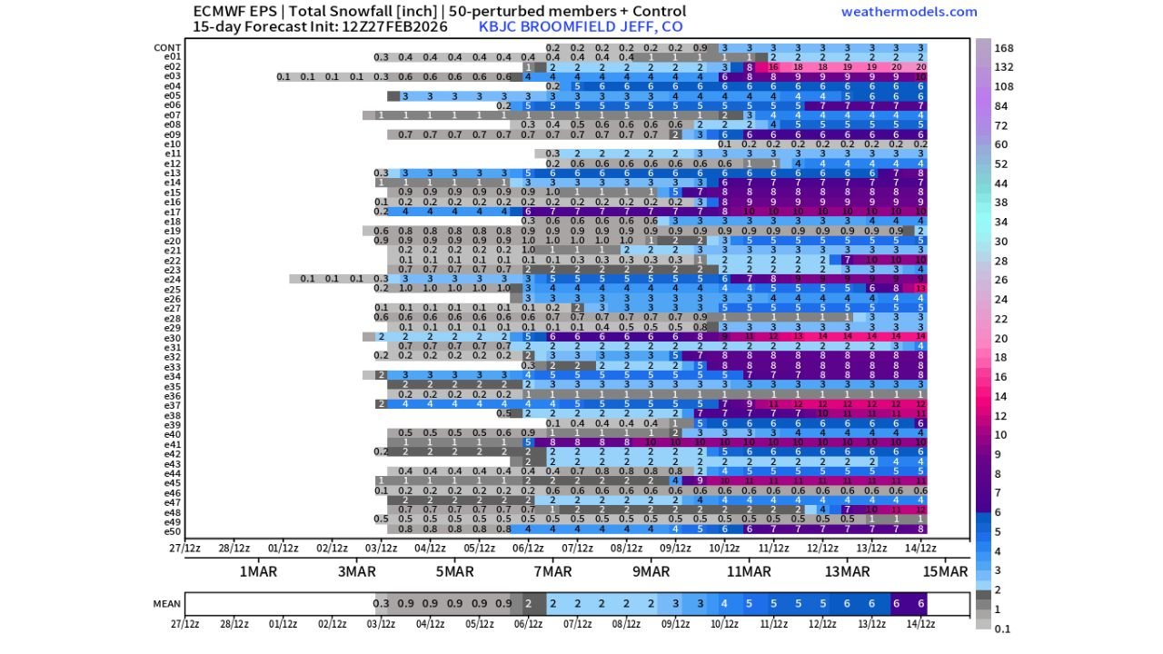
What the European Ensembles Show
The ECMWF ensemble snowfall guidance for the Denver/Broomfield area indicates:
• 95%+ of members show at least some snowfall next week
• Most solutions cluster around light to moderate totals
• A few outlier members suggest 6–12 inches
The key takeaway is that snow chances are elevated — but snowfall amounts vary significantly among ensemble members.
That spread tells us confidence in exact totals remains limited.
Rain vs. Snow Still a Key Question
Another major factor is temperature.
Forecast discussions highlight that:
• Cooler air is expected to move into the West
• The storm track looks reasonably favorable for Colorado
• Mild air may still linger near the surface
That means the rain-versus-snow split has not yet been resolved.
If temperatures stay marginal, lower elevations — including Denver — could see more rain or mixed precipitation rather than a high-impact snow event.
Second Week of March: More Signals, Still Uncertain
Looking beyond next week, ensemble data continues to show:
• 90%+ snow probabilities during the second week of March
• Several members producing moderate accumulations
• Wide spread in totals
However, that time frame sits 7–14 days out — far too early for storm-specific predictions.
While a few ensemble members display double-digit snowfall, it is not scientifically responsible to lock in a major snowstorm forecast that far in advance.
Why Social Media Snow Hype Can Be Misleading
Long-range model graphics often circulate online without proper context.
Key considerations:
• Ensemble probability does not equal guaranteed totals
• Single deterministic runs can overstate impacts
• Storm track and temperature profile matter more than raw snowfall output
In Colorado, small temperature shifts can dramatically change outcomes, especially in the Denver metro area where elevation and marginal temperatures play a major role.
What This Means for North Carolina
For Cabarrus County and the broader North Carolina region, this western pattern shift signals a more active national weather setup as we head into March.
An unsettled West often precedes downstream changes in the Plains and Southeast. While this specific snow signal is focused on Colorado, broader pattern transitions can eventually influence the eastern United States.
Bottom Line
For Denver next week:
• Snow chances are high
• Accumulation amounts remain uncertain
• Major blizzard claims are not yet supported by consistent model agreement
• Temperature profiles will determine final outcomes
We’ll continue monitoring national pattern shifts and provide updates as confidence improves.
For clear, data-driven weather coverage — without the hype — stay with CabarrusWeekly.com.