Florida Severe Weather Outlook for February 28: SPC Highlights Central and South Florida for Storm Development Saturday
FLORIDA — A developing frontal boundary could trigger scattered storms across parts of the peninsula later Saturday, with the Storm Prediction Center outlining areas of concern mainly across central and southern sections of the state.
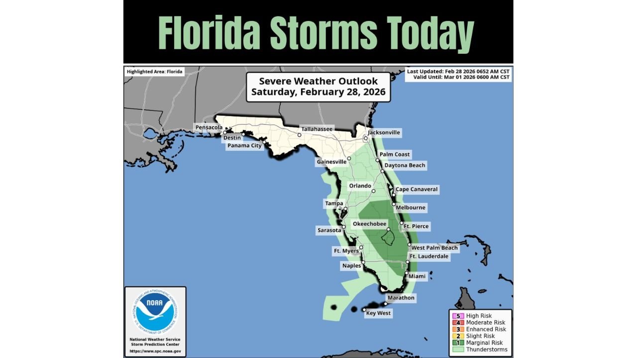
SPC Highlights Central and South Florida for Saturday
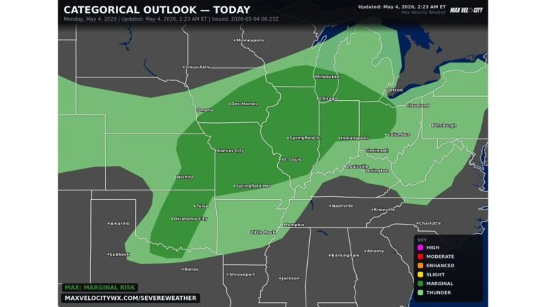
The Severe Weather Outlook valid Saturday, February 28, 2026, shows a Marginal Risk (Level 1 of 5) extending from portions of east-central Florida southward into South Florida.
Cities included within the shaded green risk zone include Orlando, Tampa, Melbourne, Okeechobee, Fort Pierce, West Palm Beach, Fort Lauderdale, Miami, Naples, Sarasota, and Fort Myers. The darker green shading indicates where storm coverage and isolated stronger cells could develop later in the day.
Northern Florida, including Tallahassee, Panama City, Destin, and Pensacola, remains outside the highlighted risk area, suggesting the primary instability and frontal interaction will focus farther south.
Frontal Energy Could Spark Afternoon Storms
The setup points to frontal line energy interacting with daytime heating, especially across central and southern Florida. As temperatures climb through the afternoon, localized instability may allow thunderstorms to develop along and ahead of the boundary.
While the risk level remains on the lower end of the scale, isolated storms could still produce:
Brief heavy downpours
Gusty winds
Frequent lightning
Storms are most likely to pop up later in the afternoon and into the evening hours, particularly in areas shaded darker green on the outlook map.
South Florida and the East Coast in Focus
The corridor from Daytona Beach south through Cape Canaveral, Melbourne, West Palm Beach, Fort Lauderdale, and Miami appears positioned within the broader risk zone. Interior sections near Okeechobee are also included, suggesting inland storms could develop before drifting toward coastal communities.
The Keys, including Marathon and Key West, sit near the southern edge of the thunderstorm shading, meaning activity could extend into the far southern peninsula as well.
What This Means for Residents
A Marginal Risk does not signal widespread severe weather, but it does mean a few storms could briefly become strong, especially where localized boundaries enhance lift.
Residents should remain weather-aware Saturday afternoon and evening, particularly if outdoor plans are scheduled. Storms may be scattered in nature, meaning not everyone will see rain, but those under a cell could experience short bursts of intense weather.
Additional updates may refine timing and exact placement as mesoscale details become clearer through the day.
If you are in Florida and experience changing weather conditions Saturday, share your observations and storm reports with us at CabarrusWeekly.com so we can continue tracking the latest developments.