Strong Thunderstorm Slams Melbourne and Brevard County, Florida With 50 MPH Gust Potential, Hail and Intense Lightning
FLORIDA — A powerful late-day thunderstorm intensified over Melbourne and Brevard County Friday evening, producing 40–50 MPH wind gusts, hail potential, and frequent lightning as it pushed east toward the Atlantic.
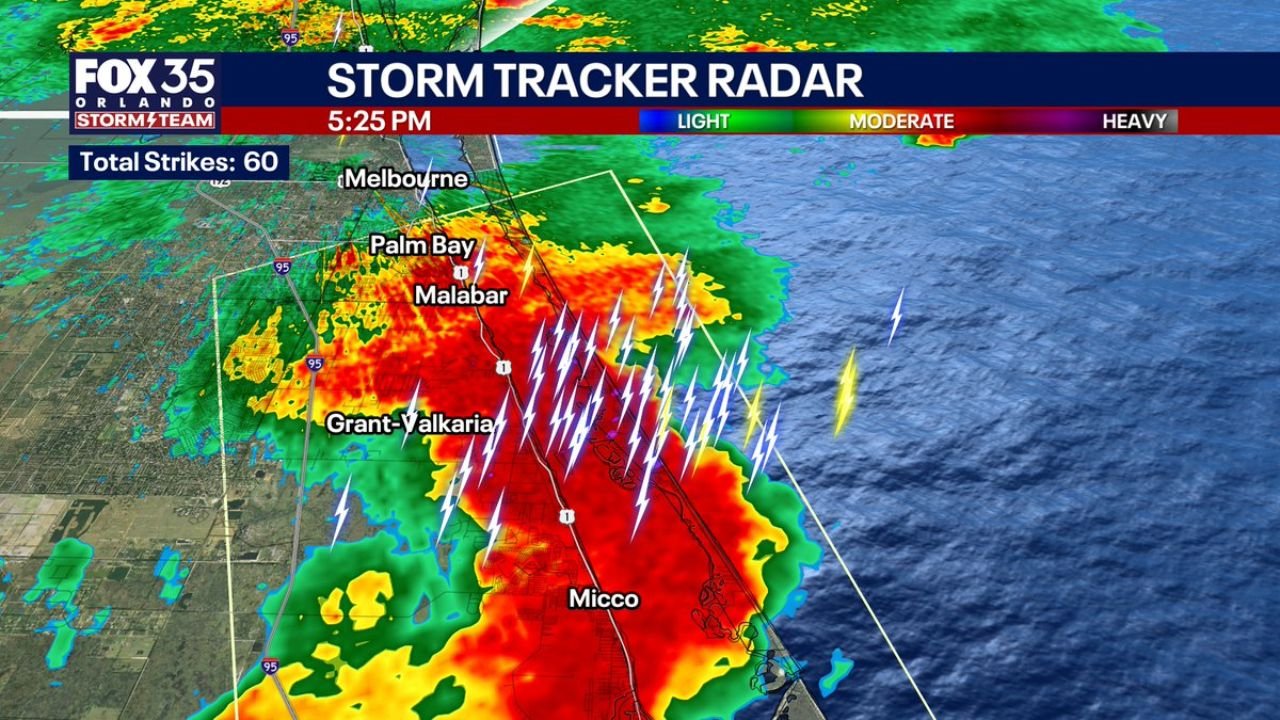
Radar Shows Intense Core Over Palm Bay, Malabar and Micco
Storm tracker radar imagery around 5:25 PM EST showed a concentrated, high-reflectivity core centered near Palm Bay, Malabar, Grant-Valkaria, and Micco, just south of Melbourne.
The storm displayed a deep red and orange signature on radar — indicating very heavy rainfall rates — along with more than 60 lightning strikes detected in a short time frame. Frequent cloud-to-ground lightning was embedded within the strongest portion of the cell as it tracked eastward.
Downburst Signature Indicates 50 MPH Wind Gust Potential
Velocity imagery from the same time frame revealed a pronounced wind shift across Melbourne Shores, Floridana Beach, Grant, Evans Pines, and Ballard Pines. Meteorologists noted a classic downburst signature, suggesting winds accelerating downward and spreading outward at the surface.
This pattern supports gust potential up to 50 MPH, particularly where the strongest reflectivity overlaps the velocity couplet. Downbursts can produce sudden, damaging wind surges capable of knocking down tree limbs and causing localized power outages.
Hail Probability Highlighted Near Coastal Communities
Hail probability data around 5:27 PM EST indicated pockets of concern near Melbourne Shores and Floridana Beach, with additional clusters near Grant and Evans Pines.
While widespread severe hail was not indicated, localized hail reports were possible within the strongest updraft cores. In Florida’s warm-season environment, even brief hail events can occur when storms rapidly intensify before moving offshore.
Storm Moving East Toward the Atlantic
The thunderstorm continued shifting east, pushing from inland Brevard County toward the Atlantic coastline. Communities along the barrier islands and immediate coastal zones were positioned to experience the brunt of the wind and lightning as the storm tracked offshore.
The rapid transition from brush fire conditions earlier in the week to strong thunderstorms underscores the dynamic February pattern shift across the region.
What Residents Should Watch For
As the storm moves offshore, lingering impacts may include:
Localized street flooding from heavy downpours
Isolated wind damage from downburst gusts
Frequent lightning posing outdoor safety concerns
Even as the strongest core shifts east, trailing rain and gusty conditions can persist briefly behind the main storm.
Residents in Melbourne, Palm Bay, Micco, and surrounding Brevard County communities should remain indoors until lightning clears the area and monitor local advisories for any damage reports or additional storm development.
If you experienced strong winds, hail, or heavy rain in Brevard County this evening, share your reports and photos with us at CabarrusWeekly.com so we can continue tracking developing weather conditions across the region.