Heaviest Snow and Rain Slam Park, Teller and El Paso Counties in Colorado as Pueblo and Fremont See Intense Banding
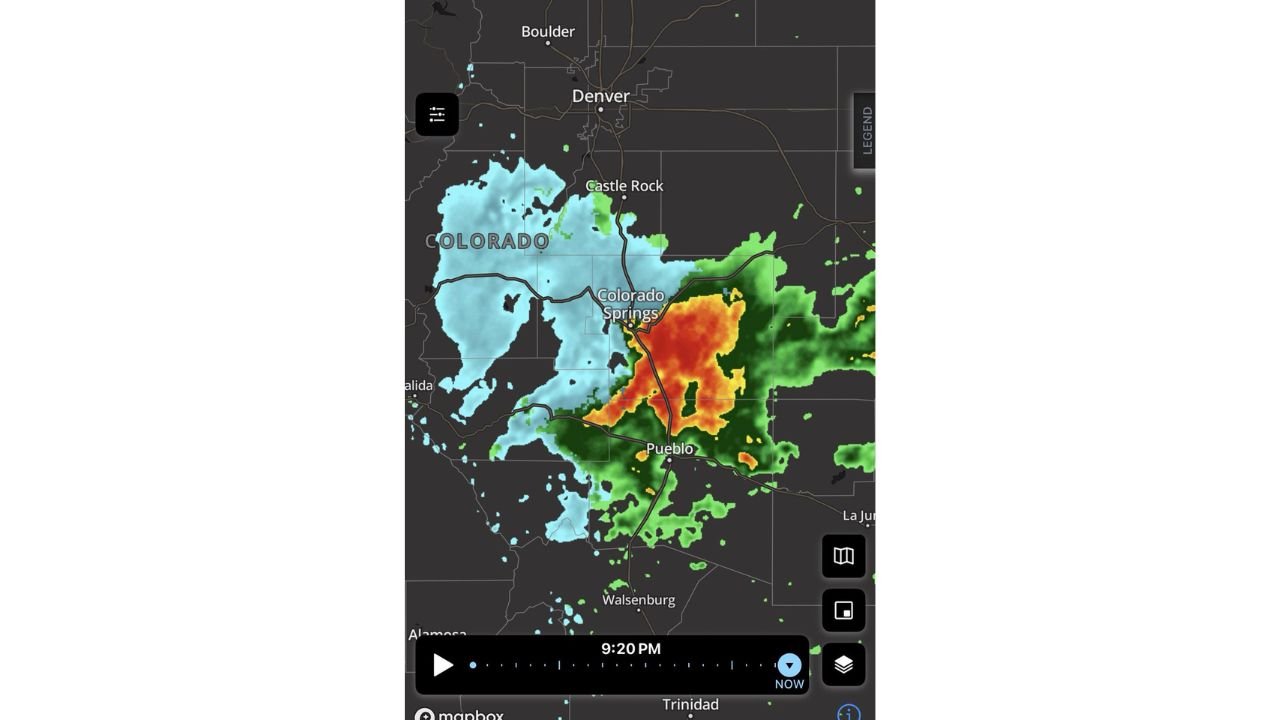
COLORADO — A concentrated band of heavy precipitation is impacting Park County, southern Jefferson County, Douglas County, Teller County, El Paso County, Pueblo County and Fremont County, with radar imagery showing the most intense returns centered from Colorado Springs south toward Pueblo.
Late evening radar indicates a dense core of heavy precipitation stretching across El Paso County into Pueblo County, with snow already being reported in higher elevations.
Heaviest Precipitation Focused South of Denver
Radar imagery shows lighter precipitation north of Castle Rock and Denver, while the most significant band is positioned:
- In and south of Park County
- Across southern Jefferson and Douglas Counties
- Through Teller County
- Into El Paso County (Colorado Springs area)
- Southward toward Pueblo and Fremont Counties
The strongest echoes — represented by deep reds and oranges — are concentrated just south and southeast of Colorado Springs, extending toward Pueblo.
Snow Reported in Teller County and Monument
Snow has been reported and observed via webcam in:
- Teller County
- Monument along the Palmer Divide
- Northern portions of Colorado Springs
The Palmer Divide often acts as a natural snow enhancement zone due to elevation, and current conditions suggest it is living up to that reputation.
Higher elevations west of Colorado Springs are seeing more widespread snow coverage, while lower elevations remain closer to the rain/snow line depending on temperature.
Pueblo and Southern El Paso County Under Heavy Band
The radar depiction shows a strong precipitation core pushing through:
- Southern El Paso County
- Pueblo County
- Northern sections of Fremont County
This band appears organized and concentrated, indicating efficient precipitation rates. Depending on surface temperatures, some areas may see heavy, wet snow while others experience cold rain.
Impact Areas
Communities potentially seeing the greatest impact include:
- Colorado Springs
- Monument
- Woodland Park
- Pueblo
- Portions of Fremont County
Travel conditions could vary significantly across short distances, particularly where elevation changes are involved.
Denver and Areas to the North Less Intense
While precipitation extends northward toward Castle Rock and Denver, the radar signature shows lighter returns compared to areas farther south.
This sharp gradient reinforces the idea that the most intense precipitation is focused south of the Denver metro area.
Bottom Line
The heaviest precipitation tonight is centered in and south of Park, Teller, El Paso, Pueblo and Fremont Counties, with snow already being observed in elevated areas including Teller County and Monument.
As temperatures fluctuate overnight, some lower-elevation locations may see changing precipitation types, while higher elevations remain firmly in snow.
CabarrusWeekly.com will continue tracking significant national weather developments and provide updates as systems evolve.