Severe Storm Corridor Expands from Dallas, Texas to Kansas City, Missouri as Isolated Tornado Threat Grows Across Oklahoma and Kansas
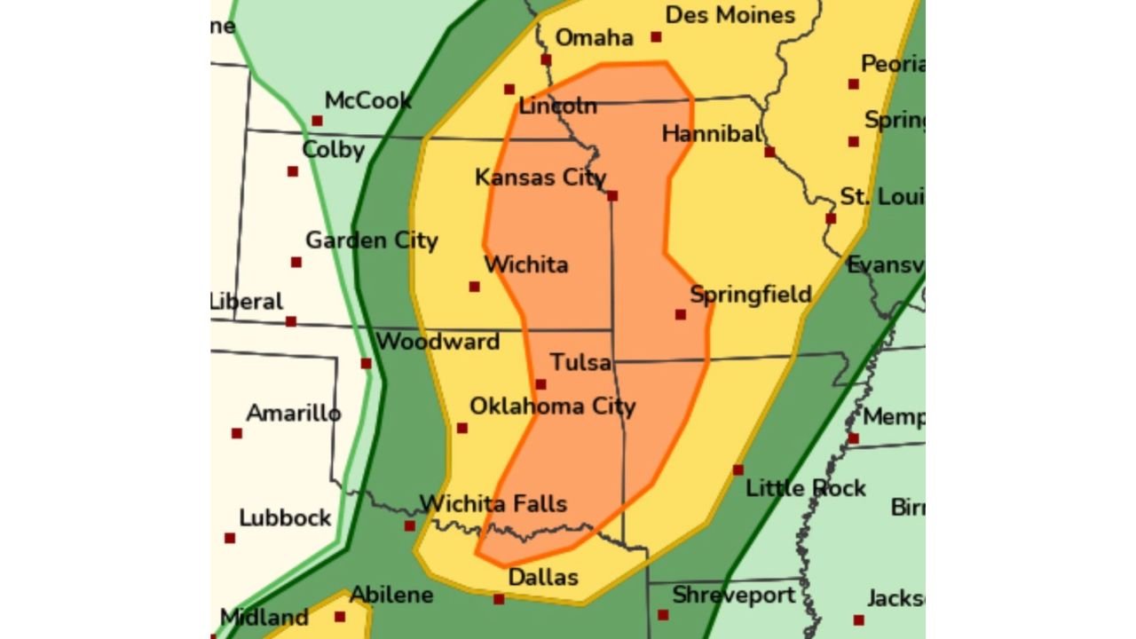
KANSAS CITY, MO — A volatile severe weather setup is taking shape across the southern and central Plains today, stretching from north Texas through Oklahoma and Kansas into western Missouri, with Kansas City positioned near the northern edge of a corridor where isolated tornadoes, large hail, and damaging winds could develop.
New forecast analysis suggests the threat may gradually shift northward through the afternoon and evening hours.
Cold Front Timing Could Change Storm Behavior
High-resolution forecast guidance indicates the cold front may move more slowly across southeast Kansas, potentially arriving well after sunset. That delay is significant.
When a cold front is slower to arrive, it allows isolated supercells to form and survive longer without being overtaken by a fast-moving squall line. This increases the chance for discrete storm structures — the type more capable of producing tornadoes and very large hail.
Communities from Wichita and Tulsa north toward Kansas City and Lincoln will need to watch how quickly storms evolve before dark.
Jet Stream Dynamics Favor Kansas and Northern Oklahoma
Upper-level dynamics are another important factor. Forecast discussions highlight that Kansas appears to be positioned under the right-entrance region of a 300 mb jet streak, an area favorable for enhanced lift.
That lift, combined with a moist and unstable air mass extending north from Dallas, Wichita Falls, and Oklahoma City, could help storms intensify as they track northeast toward Kansas City, St. Joseph, and Hannibal, Missouri.
Because of this setup, forecasters note the possibility that the higher-end threat may expand north into portions of eastern Kansas and western Missouri during peak heating hours.
Weak Cap Means Storms Could Develop Quickly
One notable feature in today’s setup is a relatively weak cap — the layer of warm air that typically suppresses storm development.
With a weak cap in place, only subtle lift may be required for thunderstorms to develop. That opens the door for scattered, fast-forming “popcorn” storms across:
- Central and eastern Kansas
- Northern Oklahoma
- Far north Texas
- Western Missouri
These storms can be difficult to forecast hours in advance because they may develop rapidly in localized pockets of instability.
Cities Within the Core Risk Zone
The most concentrated severe weather corridor currently includes:
- Dallas, Texas
- Wichita Falls, Texas
- Oklahoma City, Oklahoma
- Tulsa, Oklahoma
- Wichita, Kansas
- Kansas City, Missouri
- Lincoln, Nebraska
Surrounding cities such as Springfield, St. Louis, and Hannibal remain in a broader risk area, primarily for strong winds and hail.
What This Means Moving Forward
The overall message is clear: conditions are supportive of severe storms, but storm evolution will depend heavily on subtle atmospheric details.
If storms remain isolated and organized, the tornado risk could increase — particularly across eastern Kansas into western Missouri. If storms quickly merge into a line, the primary hazard may shift toward damaging straight-line winds.
Residents across Texas, Oklahoma, Kansas, and Missouri should stay weather-aware through the afternoon and evening.
CabarrusWeekly.com will continue monitoring updates as storms develop and move northeast across the Plains.