Rotating Storm Threat South of Omaha: High Shear and Steep Lapse Rates Signal Possible Overnight Severe Risk in Nebraska and Kansas
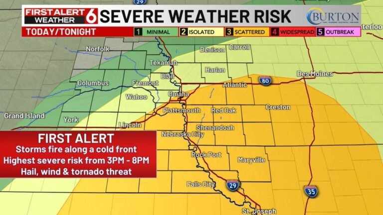
NEBRASKA — A new round of severe weather could develop tonight across parts of eastern Nebraska and northeast Kansas, particularly south of Omaha, as a strong cold front interacts with very favorable atmospheric dynamics.
Forecast analysis highlights the potential for rotating storms ahead of the front, supported by impressive wind shear and steep lapse rates that could exceed 8°C per kilometer — a combination that often signals elevated supercell potential.
Where the Threat Is Focused
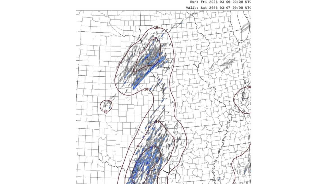
Model guidance valid late Friday into early Saturday shows a concentrated corridor of strong low-level and deep-layer shear stretching from:
- Eastern Kansas
- Into southeast Nebraska
- Northward toward the Omaha metro area
The highest shear values appear aligned along and just ahead of the advancing front, placing areas south of Omaha, including parts of northeast Kansas, in a zone where storms could organize quickly if they develop.
Further south, additional pockets of stronger forcing extend into portions of Oklahoma and north Texas, but the Nebraska–Kansas corridor stands out for organized rotation potential.
Why Rotation Is Possible
Two key ingredients are coming together:
1. Strong Wind Shear
Forecast soundings and shear plots indicate sufficient low-level and mid-level wind energy to support rotating updrafts. When storms form in environments like this, they can:
- Develop persistent mesocyclones
- Produce large hail
- Generate damaging wind gusts
- Potentially spawn tornadoes
2. Steep Lapse Rates (>8°C/km)
Lapse rates above 8°C/km suggest strong instability in the mid-levels of the atmosphere. This enhances updraft acceleration and increases the risk for:
- Large hail
- Intense storm cores
- Rapid storm strengthening
When steep lapse rates combine with strong shear, the environment becomes supportive of organized severe thunderstorms rather than ordinary cells.
Timing and Storm Mode
Storm initiation will likely depend on how quickly the front advances and whether sufficient lift develops ahead of it.
If storms form ahead of the boundary, they would have a better chance to remain discrete and rotating. However, once the front catches up, storms could transition into a more linear structure, increasing the risk of damaging straight-line winds.
The early window before upscale growth will be the most important for any rotating storm threat.
What This Means Moving Forward
While this setup is conditional — meaning storms must first develop — the atmospheric parameters suggest that any storm that does form south of Omaha could quickly intensify.
Residents in eastern Nebraska and northeast Kansas should:
- Monitor updated forecasts
- Have multiple ways to receive warnings
- Be prepared to take action if severe warnings are issued
CabarrusWeekly.com will continue tracking developments as the front pushes east and storms evolve across the Plains tonight.