Alabama Faces Multi-Day Storm Threat from Birmingham to Fort Payne Before Cool Down Into 30s by Friday Morning
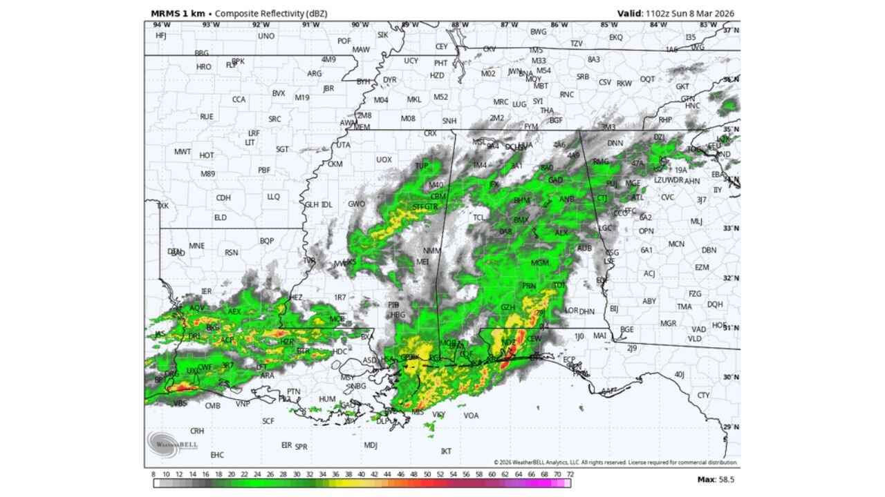
ALABAMA — Rain is already falling across much of the state early this morning, with a more organized line of thunderstorms pushing through the far southern counties and into the Florida Panhandle.
Radar imagery shows widespread showers covering central and northern Alabama, including areas near Birmingham, Tuscaloosa, Montgomery, Huntsville, and Gadsden, while heavier thunderstorms remain focused closer to the Gulf Coast.
Forecasters expect the steady rain to gradually diminish later this morning. However, additional scattered showers and isolated thunderstorms are likely to redevelop this afternoon and early tonight. Afternoon highs will remain mild, climbing into the 70s across much of the state.
Monday: Low-End Severe Risk Across Much of Alabama
A disturbance moving into the region Monday will bring another round of showers and thunderstorms statewide.
The Storm Prediction Center has outlined much of Alabama in a marginal risk category. This includes cities such as:
- Birmingham
- Huntsville
- Decatur
- Tuscaloosa
- Montgomery
- Auburn
- Mobile
The overall severe threat remains low, but a few storms could produce gusty winds. Widespread severe weather is not expected at this time.
Tuesday: Brief Lull Before Stronger System
Most of Tuesday is forecast to be relatively quiet, with only isolated showers possible. This break will be short-lived.
Attention then turns to a stronger cold front expected to sweep into the state Wednesday night.
Wednesday Night: Organized Line Along and North of I-59
Forecast guidance shows a more organized line of thunderstorms moving into Alabama Wednesday night.
The Storm Prediction Center has defined a more notable severe weather risk along and north of the Interstate 59 corridor, including:
- Tuscaloosa
- Birmingham
- Gadsden
- Fort Payne
- Huntsville
At this point, strong straight-line winds appear to be the primary concern. However, forecasters caution that an isolated tornado cannot be ruled out, particularly in areas where storm rotation can briefly develop within the line.
The timing suggests storms will move through during the evening and overnight hours, which increases the importance of having multiple ways to receive weather warnings.
Cooler Air Arrives Late Week
Behind the front, skies turn mostly sunny Thursday, but noticeably cooler air will settle across the state.
High temperatures will fall into the 55–65 degree range statewide. By daybreak Friday, temperatures across North Alabama — including Huntsville, Decatur, and Gadsden — could drop into the 34–42 degree range.
This represents a significant cooldown compared to the mild 70s earlier in the week.
Weekend Outlook
Looking ahead to the weekend of March 14–15, conditions currently appear dry and pleasant across Alabama.
Bottom Line
Alabama faces multiple rounds of unsettled weather this week, beginning with widespread rain today, a low-end severe risk Monday, and a stronger organized line of storms Wednesday night — especially from Tuscaloosa through Birmingham and north toward Fort Payne.
While the overall threat remains manageable at this stage, strong winds and isolated severe storms will need to be monitored closely before cooler air settles in late week.
CabarrusWeekly.com will continue to track developments as the midweek storm system approaches.