Southwest Heat Dome Expands Across California, Arizona, Texas While Northeast Faces Cooler Pattern in Late March Outlook
NORTH CAROLINA — A dramatic split in the nation’s temperature pattern is emerging, with extreme heat building across the Southwest while cooler air dominates parts of the Northeast heading into late March.
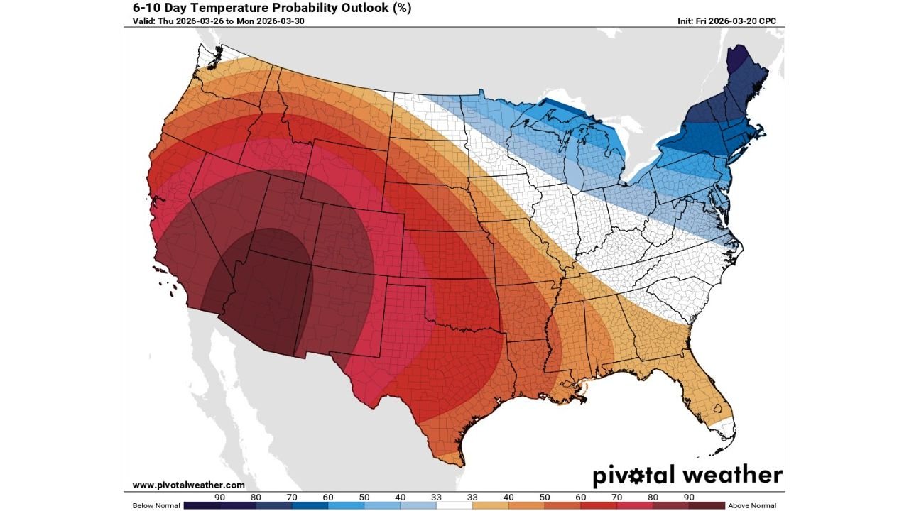
Southwest Heat Dome Shows Rare 90%+ Confidence
The latest 6–10 day outlook highlights an unusually strong and persistent heat signal centered over California, Nevada, Arizona, and New Mexico, where probabilities for above-average temperatures exceed 90%.
This level of confidence is rare in medium-range forecasting and signals a highly stable atmospheric pattern. The core of the heat dome stretches from the deserts of the Southwest into parts of inland California, where temperatures are expected to run significantly above seasonal norms for multiple consecutive days.
Meteorologists note that this marks an extended streak of forecasts showing the same region under intense warmth, reinforcing the likelihood of prolonged heat rather than a short-lived spike.
Heat Expands Into Texas, Oklahoma, and the Central Plains
Beyond the Southwest, the warm pattern spreads eastward into Texas, Oklahoma, Kansas, and parts of Colorado, where probabilities range between 60% and 80% above normal.
This suggests a broad warm sector covering much of the southern and central United States, with daytime highs climbing well above late-March averages. Cities across Texas and the southern Plains could experience early-season heat conditions more typical of late spring.
Even portions of the lower Mississippi Valley and Gulf Coast are expected to trend warmer than normal, though with slightly lower confidence compared to the Southwest core.
Sharp Temperature Contrast Develops Across Midwest and Southeast
A transition zone sets up from the central Plains into the Midwest and parts of the Southeast, where temperature probabilities appear more neutral. This indicates fluctuating conditions, with no strong signal for sustained warmth or cold.
States such as Missouri, Illinois, Kentucky, and Tennessee sit near this boundary, where shifting weather systems may bring variable conditions. North Carolina and the broader Southeast fall on the edge of this gradient, meaning temperatures could swing between mild and slightly above normal, depending on storm track positioning.
Cooler Air Locks Into Northeast and Great Lakes
In stark contrast, the Northeast and Great Lakes region—including New York, Pennsylvania, Michigan, and New England—are expected to see below-normal temperatures, with probabilities reaching 50% to 70% in some areas.
This cooler pattern suggests continued influence from troughing over the eastern U.S., allowing colder air masses to dip southward. Residents in these regions should expect chilly mornings, below-average highs, and a delayed transition into spring-like warmth.
What This Means for the Overall U.S. Pattern
The forecast highlights a classic west-to-east temperature divide, with a dominant ridge in the West and a trough in the East. This setup often leads to persistent weather conditions, meaning both the heat in the Southwest and the cool in the Northeast could linger for several days.
For energy demand, agriculture, and travel planning, this type of pattern can have notable impacts. The Southwest may face increased early-season heat stress, while the Northeast continues to deal with late-season chill.
For North Carolina and surrounding areas, being positioned near the dividing line means less certainty, but generally mild to slightly warm conditions are expected overall.
Stay with CabarrusWeekly.com for continued updates as this unusual late-March temperature pattern evolves across the United States. If you’re experiencing these shifting conditions in your area, share your observations with the CabarrusWeekly.com community.