Ohio Valley and Mid-Atlantic Including Pennsylvania, West Virginia and Maryland Under Level 2 Severe Storm Risk With Supercells Bringing 2.5 Inch Hail and Damaging Winds Sunday
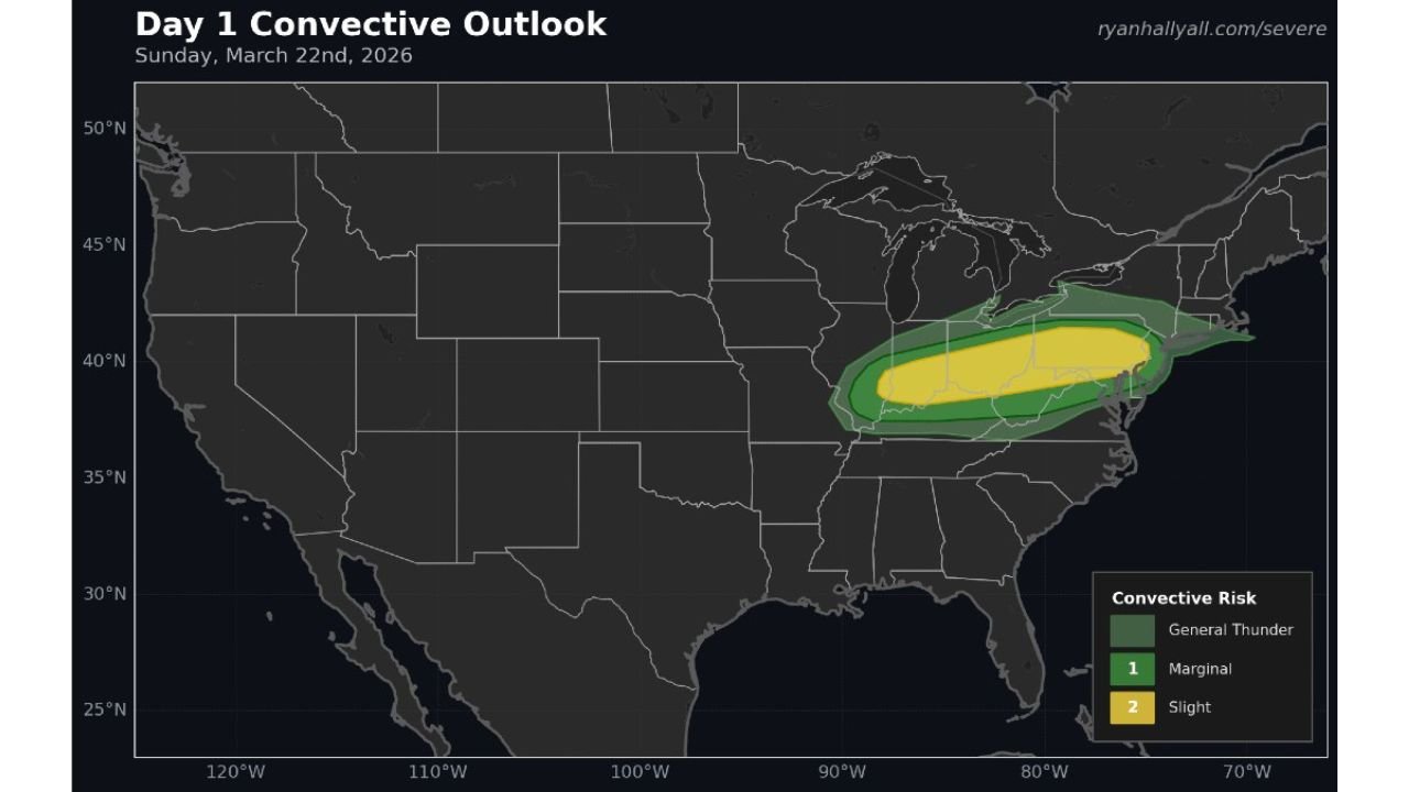
OHIO VALLEY & MID-ATLANTIC — A developing severe weather setup is expected to bring a focused corridor of strong to severe thunderstorms Sunday afternoon and evening, with the Storm Prediction Center highlighting a Level 2 “Slight Risk” across parts of the region.
Level 2 Risk Zone Expands Across Key States
The latest outlook places a Slight Risk (Level 2 of 5) stretching from portions of Ohio, West Virginia, and Kentucky into Pennsylvania, Maryland, and parts of New Jersey.
Cities including Columbus, Pittsburgh, Charleston, and Baltimore sit within or near this risk zone, where storms could organize into stronger structures as the day progresses.
Surrounding areas, including parts of Virginia and New York, fall under a broader marginal risk, meaning isolated severe storms are still possible outside the core zone.
Supercells Could Produce Very Large Hail
One of the most concerning aspects of this setup is the potential for supercell thunderstorms, which are capable of producing very large hail up to 2.5 inches in diameter.
Hail of this size can cause:
- Significant vehicle damage
- Broken windows
- Roof and siding impacts
The atmospheric environment appears supportive of rotating updrafts, which are especially efficient at producing large hailstones.
Damaging Winds Also a Major Concern
In addition to hail, storms may also bring strong to damaging wind gusts, particularly as clusters of storms begin to organize.
These winds could:
- Down trees and power lines
- Cause localized power outages
- Create hazardous travel conditions during the evening commute
The combination of hail and wind makes this a multi-hazard severe weather event.
Timing Points to Afternoon and Evening Threat
The severe threat is expected to develop during the afternoon hours and continue into the evening, aligning with peak daytime heating and increasing atmospheric instability.
Storms are likely to initiate first across the Ohio Valley, then track eastward into the Mid-Atlantic by late afternoon and evening.
Residents are urged to remain weather-aware during this timeframe, especially if traveling.
Tornado Risk Low but Not Zero
While the primary threats remain hail and wind, there is still a small chance of a tornado or two, particularly if any storms become more strongly organized.
Even a low-end tornado risk warrants attention, especially in areas where storm rotation becomes more pronounced.
What Residents Should Do Now
With this setup unfolding, residents across the risk zone should:
- Monitor weather updates throughout Sunday
- Have multiple ways to receive warnings
- Be prepared to move indoors quickly if storms approach
Even though this is not the highest risk category, Slight Risk events can still produce impactful and damaging storms.
Looking Ahead
This system highlights a classic early spring severe weather pattern, where warming temperatures and incoming disturbances combine to trigger strong storms across the Ohio Valley and Mid-Atlantic.
Conditions will continue to be monitored closely, and updates may refine the risk areas further.
Stay with CabarrusWeekly.com for continued coverage and real-time updates as this severe weather threat unfolds.