Maryland, Pennsylvania, New York and Northeast Set for Late March Chill as Warm Western Ridge Ends Baltimore’s 5-Month Cold Streak
UNITED STATES — A sharp contrast in weather patterns is emerging across the country as late March comes to a close, with a significant cooldown expected across the Northeast while the western and central U.S. remain locked in an unusually warm pattern.
Baltimore’s Rare Cold Streak Likely Coming to an End
Since October 2025, Baltimore, Maryland has experienced an unusual stretch of five consecutive months with below-normal temperatures, a rarity not seen in over two decades.
That streak now appears likely to end in March 2026 as:
- The month has featured multiple warm spells
- Temperatures already surged into the mid-80s earlier in March
- Overall averages are trending above normal despite upcoming cooler days
This marks a notable shift after a prolonged cooler-than-average period.
Northeast Braces for Late-Season Chill
Despite the warmer monthly trend, a late-season cooldown is expected across the Northeast heading into the final days of March.
Areas impacted include:
- Maryland and Washington D.C.
- Pennsylvania and New Jersey
- New York and parts of New England
This cooler pattern is being driven by:
- A deep trough dipping into the eastern United States
- Colder air filtering south from Canada
- A shift in the jet stream favoring below-normal temperatures in the East
Residents can expect a return to more chilly, early-spring conditions.
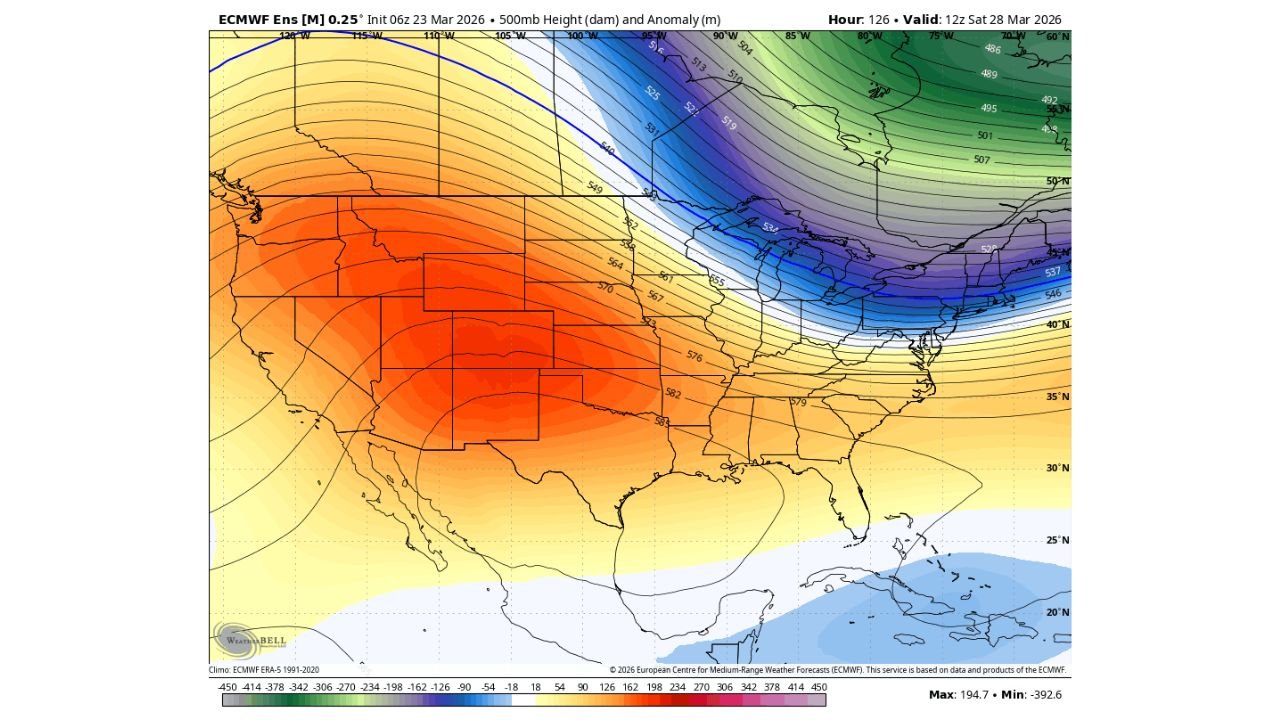
Strong Warm Ridge Dominates the West and Plains
At the same time, a powerful ridge of high pressure is building across:
- Texas, Oklahoma, and the southern Plains
- Extending into parts of the central and western U.S.
This ridge is producing:
- Well above-normal temperatures
- A stable and dry pattern
- Continued warmth spreading eastward at times
The contrast between this western warmth and eastern chill is creating a classic split weather pattern across the country.
Jet Stream Driving the Divide
The underlying cause of this dramatic contrast is the positioning of the jet stream, which is:
- Dipping southward across the Great Lakes and Northeast
- Arching northward across the western U.S.
This setup results in:
- Cooler, unsettled conditions in the East
- Warmer, more stable weather in the West and Plains
Such patterns are common during seasonal transitions but can produce sharp regional differences.
March’s Wild Temperature Swings Continue
This latest shift highlights how volatile March weather can be:
- Early-month warmth pushed temperatures into the 80s in parts of the Mid-Atlantic
- Late-month cold snaps are now returning temperatures closer to seasonal levels
- Large swings between warm and cool periods remain a defining feature of the month
These fluctuations are typical as winter fades and spring takes hold.
What to Expect Moving Forward
Looking ahead:
- The Northeast will experience a brief but noticeable cooldown
- Warmer conditions may return again as patterns shift into early April
- The broader U.S. pattern will remain active with temperature contrasts and storm systems
Final Outlook
Late March will bring a renewed chill to Maryland, Pennsylvania, New York, and the broader Northeast, even as a strong western ridge keeps much of the central U.S. unusually warm.
At the same time, Baltimore’s rare streak of below-normal months is likely ending, signaling a transition toward a warmer seasonal trend heading into spring.
Stay with CabarrusWeekly.com for continued updates on evolving U.S. weather patterns.