Illinois Indiana Ohio Kentucky Facing Thursday Severe Storm Threat With Large Hail Damaging Winds And Possible Tornadoes
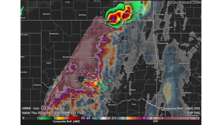
KENTUCKY — Severe weather is set to return to the Midwest and Ohio Valley on Thursday, March 26, as a developing system brings increasing concerns for strong to potentially dangerous storms across the region.
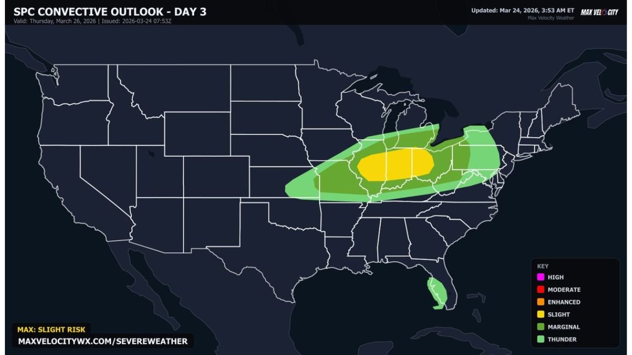
Forecast data highlights a Slight Risk (Level 2 of 5) centered across parts of Illinois, Indiana, Ohio, and Kentucky, where conditions appear favorable for organized severe thunderstorms.
Storms Expected To Ramp Up By Mid-Afternoon
The severe weather threat is expected to begin around 3 PM Thursday, with storms developing and intensifying through the afternoon and continuing into the late evening hours, potentially lasting until midnight or later.
This timing places much of the risk during a period when:
- Daytime heating is still active
- Atmospheric instability is near its peak
- Storms can quickly strengthen
Main Threats Include Large Hail And Damaging Winds
The primary hazards with this system include:
- Very large hail, capable of causing significant damage
- Damaging wind gusts, which may lead to power outages and tree damage
The risk zone stretches from:
- Central and southern Illinois
- Across Indiana
- Into Ohio
- And parts of northern Kentucky
Cities such as Indianapolis, Cincinnati, Columbus, and Louisville are all within or near the core risk area.
Tornado Risk Also In The Forecast
In addition to hail and wind, a few tornadoes are possible, particularly if storms remain more discrete before organizing into a line.
The environment is expected to support:
- Strong wind shear
- Rotating storm structures
- Rapid storm intensification
This combination increases the chance for isolated tornado development, especially during the early stages of storm formation.
Storm Structure Could Become Particularly Intense
Forecast guidance suggests the potential for well-organized storm structures, including supercells early in the event.
These storms could:
- Produce intense localized impacts
- Grow upscale into a larger storm system
- Expand the wind threat later into the evening
As storms merge, the risk may shift from isolated severe hazards to a broader damaging wind event.
Regional Impact Extends Across Midwest And Ohio Valley
The overall risk corridor spans a large portion of the Midwest and Ohio Valley, including:
- Illinois
- Indiana
- Ohio
- Kentucky
Surrounding areas may also see storms, though the most concentrated severe threat appears focused within this core zone.
Final Word
This setup marks a renewed return of severe weather to the Midwest and Ohio Valley, with a combination of large hail, damaging winds, and a few tornadoes possible Thursday afternoon through the night.
Residents across Illinois, Indiana, Ohio, and Kentucky should remain weather-aware and prepared for rapidly changing conditions.
Stay with CabarrusWeekly.com for real-time updates as this Thursday severe weather threat unfolds.