Arkansas Rain Surge Builds Overnight Into Saturday With Heavy Downpours and Low Severe Storm Risk Across the State
ARKANSAS — After a prolonged stretch of dry conditions, a much-needed round of widespread rain and thunderstorms is expected to move across the state late Friday night and continue into Saturday, bringing soaking rainfall and limited severe weather concerns.
Rain Expands Across Arkansas Late Friday Night
Forecast data shows that most of Friday daytime will remain dry, but conditions begin to shift rapidly after sunset. A developing system to the west will push moisture into the region, allowing rain and storms to spread from west to east across Arkansas overnight.
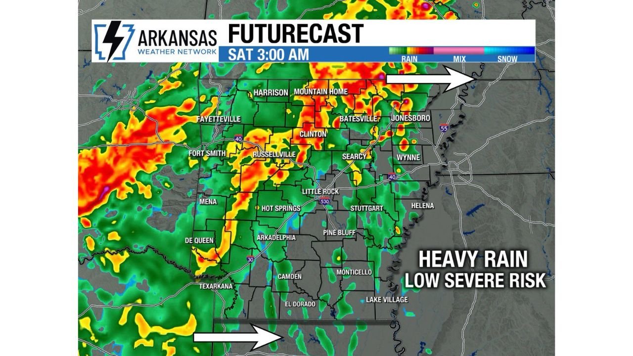
By early Saturday morning, radar projections indicate numerous areas of moderate to heavy rainfall, especially across central and northern parts of the state. Cities including Little Rock, Russellville, Clinton, and Mountain Home are expected to see steady precipitation as the system progresses.
Heavy Rainfall Becomes the Primary Impact
The biggest takeaway from this system is not severe weather, but rather widespread beneficial rainfall. Many areas that have missed out on recent precipitation now have a much higher chance of receiving measurable rain.
Localized heavier bands could produce brief downpours, especially where storms train over the same areas, leading to ponding on roads and reduced visibility during early Saturday travel hours. The rainfall coverage is expected to be broad, meaning most of Arkansas will see some level of precipitation before the system exits.
Severe Weather Risk Remains Low
While thunderstorms will be present, the overall setup suggests a low to very low severe weather risk. The environment does not strongly support widespread severe storms, but a few isolated stronger cells cannot be completely ruled out.
Any stronger storm could produce gusty winds or brief heavy bursts of rain, but the overall threat level remains limited compared to typical severe weather events. The focus stays firmly on rainfall rather than damaging impacts.
Conditions Clear Out for Easter Sunday
As the system moves eastward, rain and storms will begin clearing out by Saturday night, setting the stage for a much quieter and drier pattern.
By Sunday, conditions improve significantly across the region, leading to a dry and more stable Easter Sunday, offering a break after the active weather period. Skies are expected to gradually clear, and no additional storm threats are anticipated during that time.
A Much-Needed Shift After Dry Conditions
This rainfall event comes at an important time for Arkansas, where many areas have experienced limited precipitation in recent days. The incoming system increases the likelihood that more locations will finally see meaningful rainfall totals.
Forecast confidence remains high that this system will deliver widespread coverage, making it one of the more impactful rain events of the week despite the lack of severe weather.
As conditions evolve, residents across Arkansas are encouraged to stay aware of changing weather overnight Friday and into Saturday morning, especially during periods of heavier rainfall.
If you’re seeing rain totals build or experiencing changing conditions in your area, share your updates with the CabarrusWeekly.com community and help others stay informed.