Texas, Oklahoma, Arkansas, Missouri, Illinois and Wisconsin Face Repeated Storm Threats as Mid-April Pattern Turns Very Active Across Central U.S.
UNITED STATES — A major shift in the weather pattern is expected by mid-April, with forecasters highlighting a high-confidence transition toward a very active storm setup across the central United States, particularly from the Southern Plains into the Midwest.
After a relatively quieter stretch early in the week, conditions are lining up for multiple rounds of heavy rain and severe weather between April 12 and April 18, impacting a wide corridor of states.
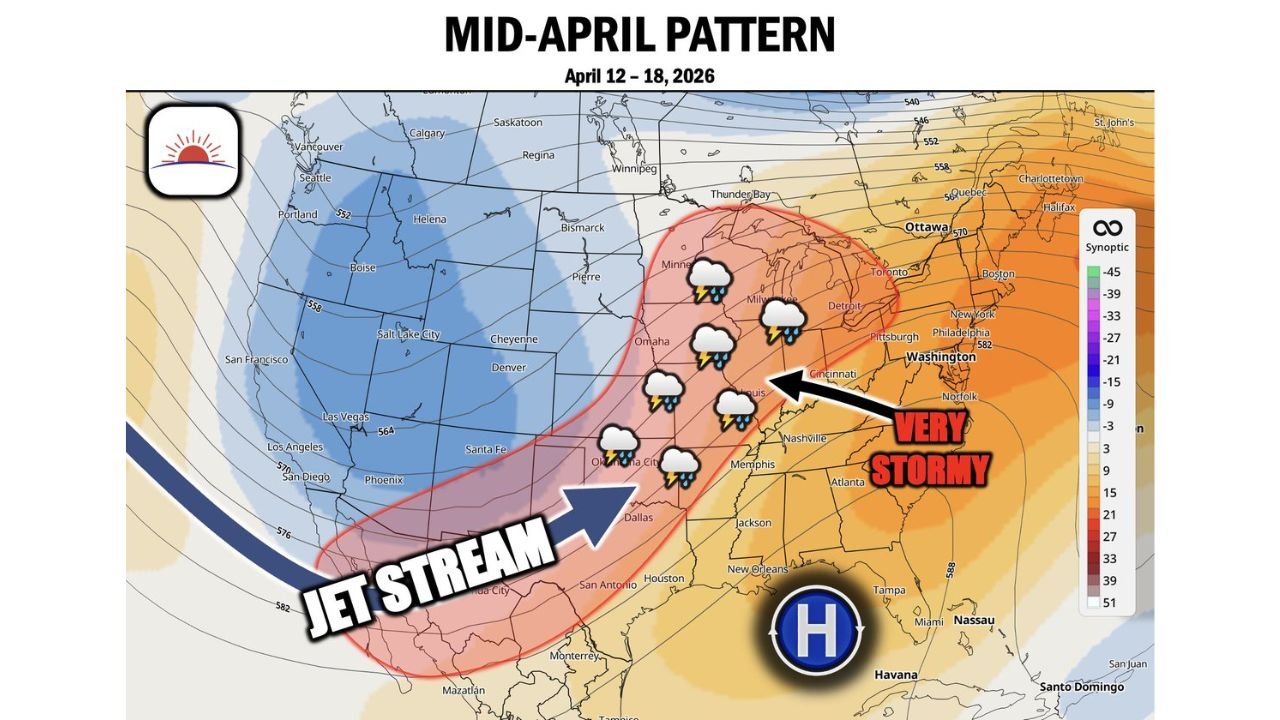
Jet Stream Locks Into Storm Corridor From Texas to Great Lakes
The developing pattern shows a strong jet stream stretching from Texas through Oklahoma, Arkansas, Missouri, Illinois, and into Wisconsin and the Great Lakes region.
This alignment is critical because it:
- Creates a consistent storm track across the same states
- Supports repeated thunderstorm development
- Enhances the risk for organized severe weather outbreaks
Cities and regions along this corridor—including Dallas, Oklahoma City, St. Louis, Chicago, and Milwaukee—could see multiple rounds of storms during this period.
“Very Stormy” Zone Expands Across Midwest and Ohio Valley
The setup highlights a broad “very stormy” zone extending from the Mid-Mississippi Valley into parts of the Midwest and Ohio Valley.
This includes:
- Missouri, Illinois, Indiana, and Ohio
- Surrounding areas near the Great Lakes
These regions may experience:
- Frequent thunderstorm clusters
- Periods of heavy rainfall
- Elevated severe weather potential over several days
The repeated nature of the storms raises concerns about accumulated rainfall and localized flooding, especially in areas hit multiple times.
High Pressure in Southeast Feeds Moisture Into Storm System
A strong high-pressure system over the Southeast, including states like Florida, Georgia, and Alabama, will play a key role in fueling this pattern.
This system will:
- Pump warm, humid air northward from the Gulf of Mexico
- Increase atmospheric instability across the Plains and Midwest
- Help sustain storm development over multiple days
This moisture feed is a key ingredient in keeping storms active and potentially more intense.
Heavy Rain and Severe Weather Likely in Multiple Waves
Unlike a single storm event, this pattern suggests several waves of storms moving through the same regions.
Potential impacts include:
- Heavy rainfall leading to flooding concerns
- Damaging winds and large hail
- Isolated tornado risks during peak setups
Each wave could reinforce the next, making this a prolonged period of active weather rather than a one-day event.
Timing Focused on April 12–18 Window
The most active period is expected during the mid-April window from April 12 through April 18, though smaller-scale events could begin earlier.
Residents across the central U.S. should prepare for:
- Changing conditions day-to-day
- Possible back-to-back storm systems
- Extended periods of unsettled weather
Central U.S. Enters Peak Spring Storm Pattern
This evolving setup is typical of spring but stands out due to its consistency and duration, signaling a more impactful stretch than usual.
The combination of:
- Strong jet stream support
- Gulf moisture supply
- Repeated storm tracks
…is creating a classic but potentially intense mid-April severe weather pattern.
Stay With Cabarrus Weekly for Ongoing Weather Updates
As this active pattern develops, updates on timing, severity, and impacted regions will become clearer.
Stay with Cabarrus Weekly for continuous coverage of severe weather risks, heavy rain potential, and evolving conditions across the United States.