Southern States From Texas to Tennessee See Surge in Growing Degree Days as Mid-April Warmth Accelerates Crop Development
UNITED STATES — As planting season ramps up across much of the southern United States, a significant weather signal is emerging that could have a major impact on agriculture. New 10-day forecasts show widespread above to much above normal Growing Degree Days (GDU), indicating a rapid acceleration in crop growth across several key farming regions.
What the Latest GDU Forecast Is Showing
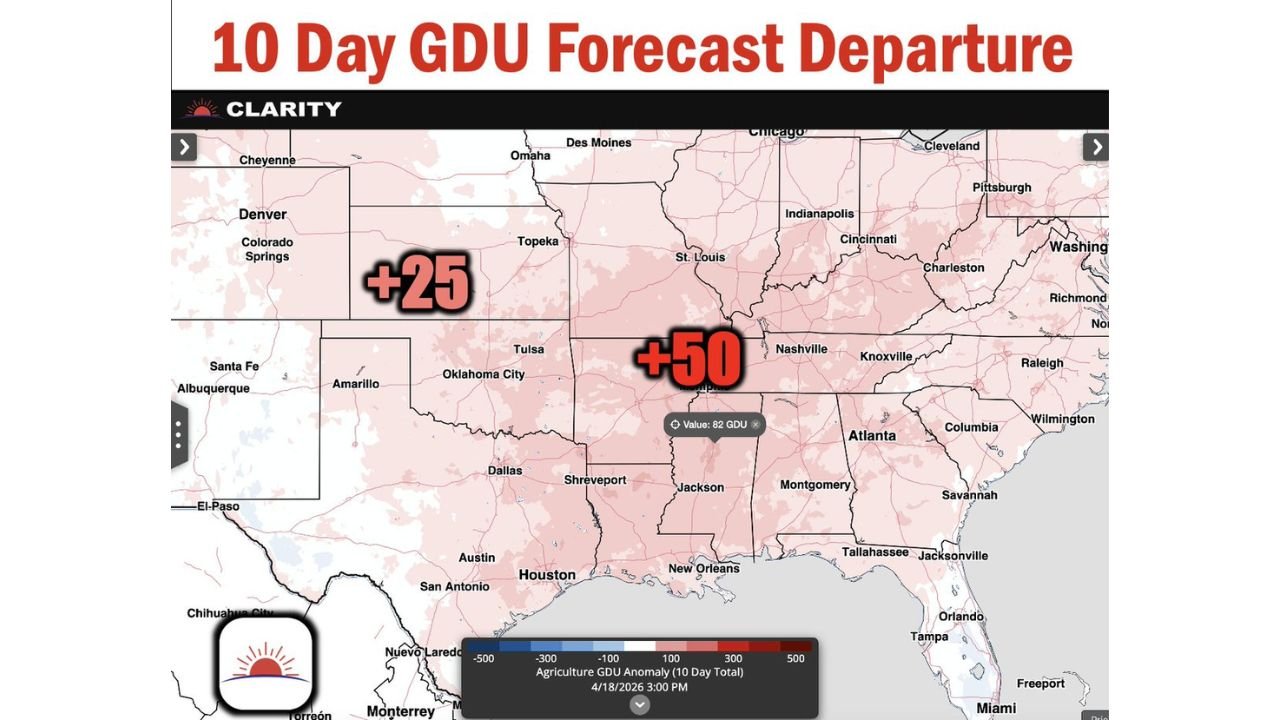
The latest 10-day GDU departure outlook highlights a broad zone of increased heat accumulation stretching across the southern Plains into the Southeast.
Key anomalies include:
- +25 GDU across parts of Texas, Oklahoma, and the southern Plains
- +50 GDU across portions of Arkansas, Mississippi, and Tennessee
- Elevated values extending into Louisiana, Alabama, and surrounding areas
These numbers represent a notable departure above seasonal averages, signaling that crops may develop faster than usual over the next 10 days.
Why Growing Degree Days Matter Right Now
Growing Degree Days are a critical agricultural metric used to estimate:
- Crop growth stages
- Germination progress
- Timing for fertilization and pest control
With planting already underway across many southern states, this surge in GDUs means:
- Crops could emerge and mature more quickly
- Farmers may need to adjust management timelines
- Early-season growth could get a temporary boost from sustained warmth
Regions Seeing the Strongest Impact
The most significant acceleration in crop development is expected across:
- Mississippi Valley (Mississippi, Arkansas)
- Lower Tennessee Valley (Tennessee)
- Parts of Louisiana and Alabama
- Extending west into eastern Texas and Oklahoma
These areas are seeing the highest positive GDU anomalies, indicating the strongest influence from above-normal temperatures.
What’s Driving This Pattern
The surge in GDUs is being fueled by:
- A persistent warm air mass across the southern U.S.
- Increased sunlight and daytime heating
- Lack of prolonged cold intrusions during this period
This setup allows temperatures to remain consistently above average, leading to steady heat accumulation day after day.
Potential Benefits and Risks for Agriculture
While higher GDUs can be beneficial, they also come with challenges.
Benefits:
- Faster germination and early crop establishment
- Potential for earlier harvest timelines
Risks:
- Increased water demand for crops
- Higher chances of stress if dry conditions develop
- Possible mismatch between growth stages and future weather events
What Farmers Should Watch Next
With such a strong early-season signal, attention now turns to:
- Whether this warmth continues beyond the 10-day window
- Rainfall patterns to support the accelerated growth
- Any potential late-season cold snaps that could impact rapidly developing crops
Cabarrus Weekly Perspective
This developing pattern across the southern United States is a reminder that spring weather doesn’t just bring storms — it also plays a critical role in agriculture.
With above-normal Growing Degree Days spreading from Texas through the Mississippi Valley and into Tennessee, the next couple of weeks could significantly shape the early stages of the growing season.