Maryland and Mid Atlantic Set for Dramatic Temperature Swing From 20s to 80s With Storm Threat Next Week
MARYLAND — A sharp and potentially volatile weather shift is unfolding across the Mid-Atlantic, where early morning chill in the 20s and 30s is expected to rapidly flip into summer-like warmth next week, raising concerns about strong thunderstorms returning once again.
This pattern of extreme temperature swings has already defined much of the spring season, and the latest forecast suggests that trend is far from over.
Cold Start Now but Rapid Warm Up Ahead
Current conditions across Maryland and nearby states are notably cold for April, with:
- Morning temperatures dropping into the 20s and 30s
- Chilly air dominating much of the eastern United States early in the period
However, this will not last long.
By early next week, temperatures are expected to surge dramatically, with afternoon highs pushing into the 80s across Maryland, Virginia, and surrounding areas — a swing of nearly 40 to 50 degrees in just a few days.
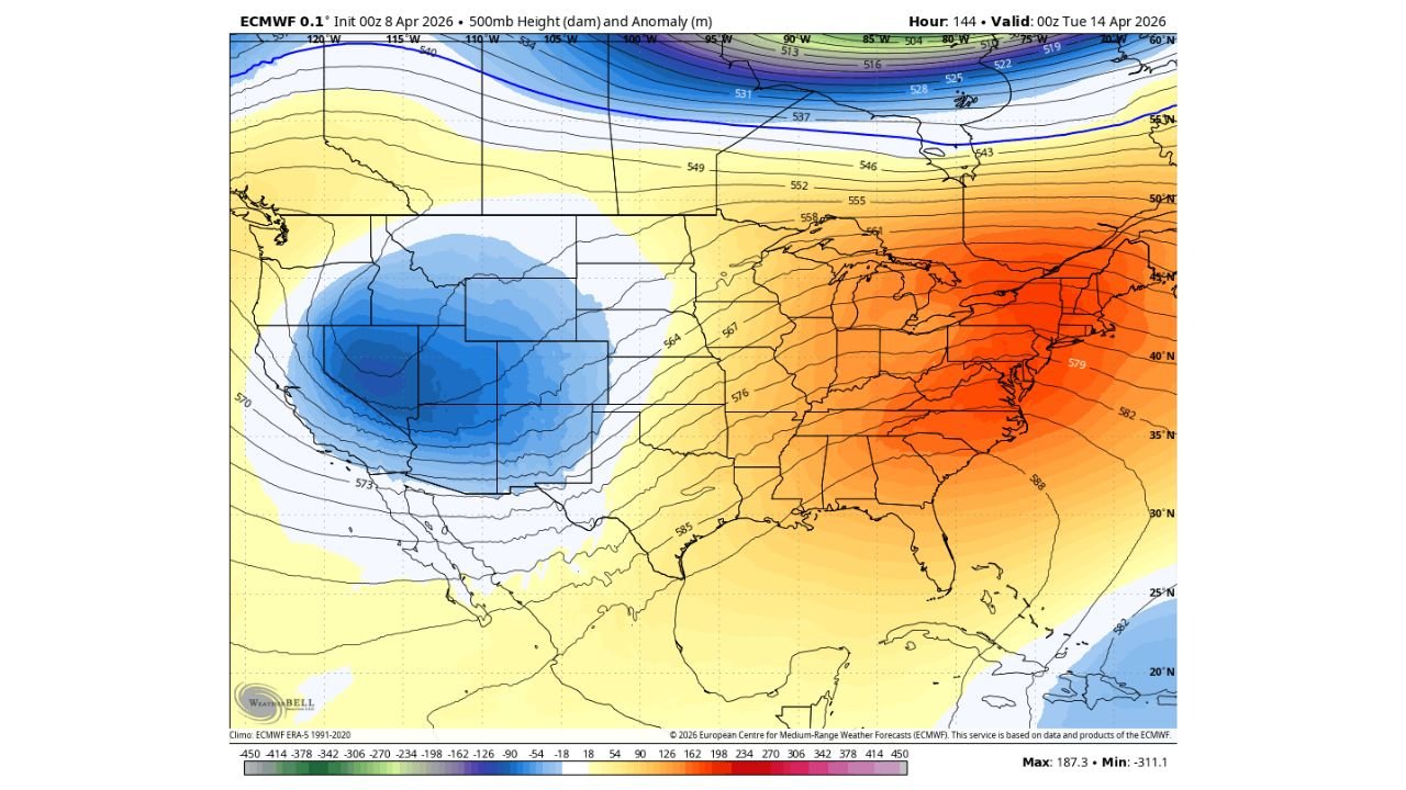
What’s Driving This Sudden Change
The large-scale atmospheric setup shows a clear contrast across the country:
- A deep trough (cool, unsettled air) is developing over the western United States
- At the same time, a strong ridge (warm air buildup) is expanding across the eastern U.S., including the Mid-Atlantic
This configuration allows warm air to surge northward rapidly, replacing the current cold conditions and setting the stage for instability.
Warm Air Could Trigger Strong Storms Again
Each time this pattern has played out so far this spring, the result has often been rounds of strong thunderstorms, sometimes referred to as “boomers.”
That risk is returning once again.
As warm, moist air builds across Maryland and the surrounding region:
- The atmosphere becomes increasingly unstable
- Clashing air masses — warm vs. lingering cool air — create storm potential
- Passing disturbances from the west may act as triggers for storm development
This combination means that thunderstorms are likely to develop sometime next week, with the possibility of strong to severe storms depending on timing and exact conditions.
Mid Atlantic Region Could See Another Active Stretch
The setup suggests that the Mid-Atlantic, including:
- Maryland
- Virginia
- Pennsylvania
- Delaware
- Washington, D.C.
could once again find itself in an active weather pattern, especially during the transition from cool to warm conditions.
While it is still too early to determine the exact severity, the ingredients are aligning for another round of impactful weather following the warm-up.
Cabarrus Weekly Perspective
This type of rapid temperature swing is more than just a comfort issue — it’s a signal of atmospheric instability, and that often translates into storm development.
Residents across Maryland and the Mid-Atlantic should be prepared for:
- A quick shift from winter-like mornings to summer-like afternoons
- The potential for thunderstorms returning during the warm-up phase
- Changing conditions that could evolve quickly as the pattern develops
As always during spring, large temperature swings often come with increased storm risk, making next week a period worth watching closely.