90 Degrees in April: Alabama and the Deep South Brace for Their Hottest Week of 2026 as Drought Tightens Its Grip and Rain Stays Away for Days
ALABAMA — The Deep South is about to experience its warmest stretch of weather so far in 2026, with afternoon highs climbing well into the 80s across Alabama this week and some spots pushing to 90 degrees by the latter half of the week. Drought conditions are set to intensify as rain and storms are pushed well away from the region for at least the next six to seven days.
April Feeling Like July: The Heat Taking Over Alabama This Week
An upper-level ridge sitting over the region is driving temperatures well above what is typical for April. Afternoon highs across Alabama and the Deep South will stay firmly in the mid to upper 80s through most of the week before peaking late in the week.
At Birmingham-Shuttlesworth International Airport, forecast data tells the story clearly:
| Date | Day | High (F) | Low (F) |
|---|---|---|---|
| April 12 | Sunday | 86 | 62 |
| April 13 | Monday | 83 | 62 |
| April 14 | Tuesday | 86 | 62 |
| April 15 | Wednesday | 87 | 62 |
| April 16 | Thursday | 86 | 64 |
| April 17 | Friday | 90 | 65 |
| April 18 | Saturday | 89 | 67 |
| April 19 | Sunday | 81 | 64 |
| April 20 | Monday | 77 | 55 |
| April 21 | Tuesday | 80 | 54 |
| April 22 | Wednesday | 82 | 58 |
Friday April 17 stands out as the peak of this heat event, with Birmingham forecast to hit 90 degrees — a temperature more commonly associated with the height of summer than mid-April. Saturday follows closely at 89 degrees before a modest cooldown begins Sunday into Monday.
The Same Ridge Keeping It Hot Is Also Keeping the Rain Out
The upper-level ridge responsible for this warmth is doing double duty — it is also acting as a wall, pushing rain and thunderstorms well to the west and north of Alabama. That pattern is expected to hold for at least the next six to seven days.
The 7-day precipitation forecast through Sunday April 19 at 8 a.m. EDT confirms this clearly. Alabama receives zero measurable rainfall during this entire period. What rain does fall is concentrated far to the west — across Louisiana, Arkansas, and the western edges of Mississippi — with amounts ranging from 0.1 to over 2 inches in those areas. None of it reaches Alabama.
| Area | 7-Day Rainfall Forecast |
|---|---|
| Alabama | 0.00 inches |
| Western Mississippi | Trace to 0.2 inches |
| Louisiana and Arkansas | 0.3 to 2.3 inches |
For a region already dealing with drought, a week of 86 to 90 degree heat with zero rainfall is a damaging combination.
Drought Will Intensify Before It Gets Better
With no rain on the way and temperatures running well above normal, drought conditions across Alabama and the Deep South are expected to worsen this week. The heat will accelerate evaporation, pulling additional moisture out of already dry soils.
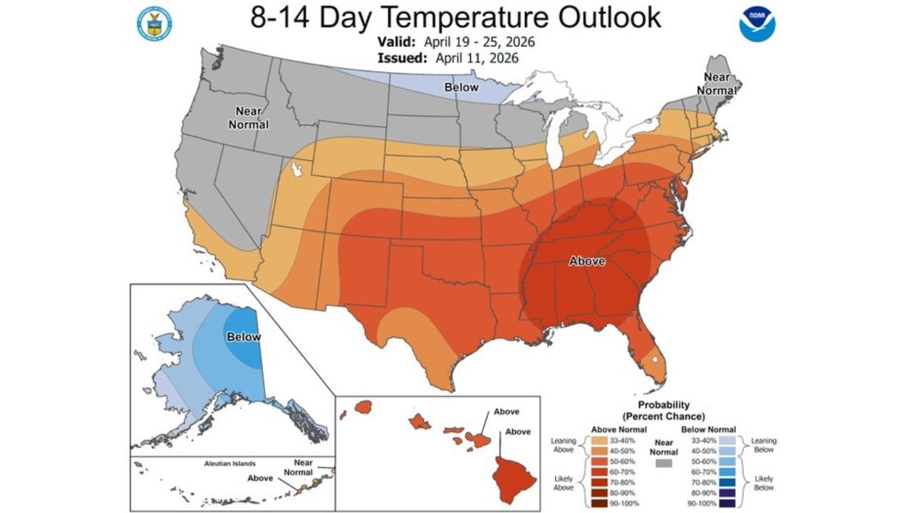
The NOAA 8 to 14 day temperature outlook, valid April 19 through April 25 and issued April 11, shows no immediate temperature relief on the horizon either. Alabama and the broader Deep South fall within a zone carrying a 70 to 80 percent probability of above-normal temperatures during that extended period — one of the highest confidence signals on the entire map.
The Southeast is clearly at the bullseye of this prolonged warmth.
There Is a Light at the End of the Tunnel — But It Is 10 to 15 Days Out
Despite the difficult stretch ahead, there is a positive signal worth watching. Evidence is building for a pattern shift in approximately 10 to 15 days that would bring some needed rain and thunderstorms back to Alabama and the Deep South.
This aligns with the modest cooldown visible in the Birmingham forecast beginning around April 19 and 20, where highs drop back into the upper 70s before climbing again. A more meaningful pattern change bringing organized rainfall would be a significant development for drought-stressed areas across the region.
That shift, if it materializes on schedule, could not come soon enough.
What Alabama Is Facing This Week at a Glance
| Factor | Details |
|---|---|
| Peak heat | 90 degrees Friday April 17 in Birmingham |
| Warmest stretch | April 15 through April 18 |
| Rainfall next 7 days | None expected across Alabama |
| Drought trend | Intensifying through the week |
| Extended temperature outlook | 70-80% chance above normal April 19-25 |
| Pattern change signal | Possible in 10 to 15 days |
Alabama is heading into its hottest and driest stretch of the year so far, with no meaningful relief in sight until a potential pattern shift arrives later this month. The combination of record April warmth, zero rainfall, and worsening drought makes this a week to watch closely across the state and the broader Deep South.
Stay with CabarrusWeekly.com for daily weather updates, drought tracking, and the latest on when relief rain finally returns to Alabama and the Deep South.