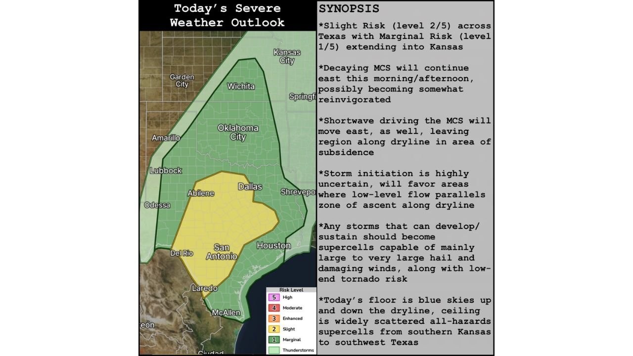
Supercells on the Table: Texas Faces Slight Risk of Severe Storms Today as Uncertainty Hangs Over the Dryline from Southern Kansas to Southwest Texas
TEXAS — The Storm Prediction Center has placed Texas under a Slight Risk of severe weather today, with a Marginal Risk stretching north into Kansas. The setup is an uncertain one — but forecasters are clear that if storms manage to fire, they would likely become dangerous supercells capable of producing all hazards.
A Tricky Setup Along the Dryline That Could Still Turn Dangerous
Today’s severe weather threat is rooted in a mistimed shortwave that is leaving the dryline sitting in an area of subsidence — conditions that suppress storm development. Storm initiation is described as highly uncertain, and forecasters acknowledge that blue skies may dominate up and down the dryline for much of the day.
However, that uncertainty cuts both ways. Storm initiation will favor areas where low-level flow parallels the zone of ascent along the dryline, and if storms can break through the cap and sustain themselves, the environment is more than capable of supporting significant severe weather.
A decaying MCS is also continuing to move east this morning and into the afternoon, with some potential to become reinvigorated as it pushes through the region. The shortwave driving that system is moving east as well, further complicating the overall picture along the dryline.
Risk Zones: Who Is Under the Gun Today
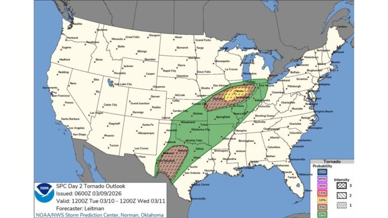
The SPC severe weather outlook covers a large portion of the south-central United States today, with two distinct risk levels in place.
| Risk Level | Areas Covered |
|---|---|
| Slight Risk — Level 2/5 | Texas, including Dallas, San Antonio, Houston, Abilene, Odessa, Del Rio, Laredo, McAllen |
| Marginal Risk — Level 1/5 | Extending north through Oklahoma City, Wichita, and into Kansas including Garden City and Kansas City area |
The Slight Risk zone covers a large swath of Texas, stretching from the Panhandle region near Lubbock and Amarillo south through the heart of the state down to the Rio Grande. The Marginal Risk zone extends well north through Oklahoma and into Kansas, covering cities including Oklahoma City, Wichita, and areas near Kansas City.
If Storms Fire, Expect Supercells With All Hazards
This is the part of the forecast that demands attention. The overall chance of storms getting going today is uncertain — but the ceiling on this setup is significant. Any storm that develops and sustains itself today is expected to become a supercell, and those supercells would be capable of producing:
- Large to very large hail as the primary and most likely hazard
- Damaging winds alongside the hail threat
- Low-end tornado risk for any sustained supercell that develops
The range today runs from blue skies all day along the dryline to widely scattered all-hazards supercells from southern Kansas to southwest Texas. That is an unusually wide range of outcomes, and it reflects just how much this setup hinges on whether storms can initiate at all.
The Bottom Line for Texas and Kansas Today
The atmosphere is loaded but the trigger is questionable. A mistimed shortwave has left the dryline in subsidence, making storm initiation a difficult problem for forecasters to solve today. The best chance for any storms that do develop will be in areas where low-level flow lines up favorably along the dryline.
If storms do not fire, today is a non-event. If they do, the situation could escalate quickly into a dangerous supercell outbreak from southern Kansas through southwest Texas. Residents across the Slight and Marginal Risk zones should remain weather-aware today and have a way to receive warnings quickly if the atmosphere decides to cooperate.
Stay with CabarrusWeekly.com for live severe weather updates, storm reports, and the latest watches and warnings across Texas and the southern Plains.