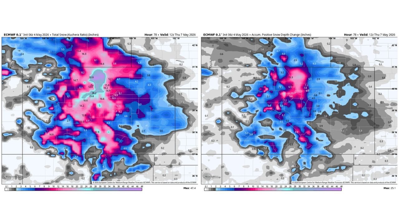
Colorado and Wyoming Face Up to 47 Inches of Total Snowfall Through Thursday May 7 With Up to 25 Inches Sticking as Warm Ground and Leafed Out Trees Create Major Damage Risk
COLORADO AND WYOMING — A significant late season snowstorm is bearing down on Colorado and Wyoming with model guidance valid through 12Z Thursday, May 7, 2026 showing total snowfall amounts reaching as high as 47.4 inches in the mountains, while accumulated positive snow depth change — the more realistic measure of what will actually stick — peaks at 25.1 inches across the core zone.
What Falls vs What Sticks Are Two Very Different Numbers
The critical distinction with this storm is the difference between total snowfall and what actually accumulates on the ground. Warm ground temperatures will prevent much of the snow from sticking to the surface itself. However, anything elevated off the ground — including all leafed out trees — will accumulate snow fully.
This creates a serious tree damage and power outage risk across the region. Heavy wet snow loading onto trees that are already fully leafed out for the season is a recipe for broken branches and downed limbs, a scenario that has caused significant damage in Colorado during previous late season events.
Total Snowfall Forecast Through Thursday Morning
Total snow guidance using the Kuchera ratio shows the following amounts through 12Z Thursday, May 7:
| Zone | Total Snow Forecast |
|---|---|
| Highest mountain peaks core | Up to 33.9 to 47.4 inches |
| Central Colorado mountains | 18.6 to 28.2 inches |
| Eastern Colorado foothills | 8.1 to 16.6 inches |
| Southern Wyoming | 5.5 to 16.3 inches |
| Eastern Plains fringe | 2.1 to 5.7 inches |
What Will Actually Stick — Positive Snow Depth Change
The positive snow depth change map — a far more accurate picture of accumulating snow — shows the following sticking totals through Thursday:
| Zone | Snow Depth Accumulation |
|---|---|
| Central Colorado mountain core | 11.7 to 13.3 inches |
| Front Range and foothills | 6.5 to 9.8 inches |
| Southern Colorado | 5.0 to 8.9 inches |
| Southern Wyoming | 3.2 to 6.0 inches |
| Eastern Colorado fringe | 1.6 to 3.8 inches |
Leafed Out Trees Are the Biggest Concern
With trees fully leafed out across the region, heavy wet snow will load onto branches that are carrying a full canopy of leaves. This dramatically increases the weight burden on trees and significantly raises the risk of widespread branch breakage, downed trees and power outages across Colorado and Wyoming through Thursday.
Details on exact amounts and timing continue to evolve. Residents across the region should prepare for potential power disruptions and avoid parking under trees during the storm.
Stay with CabarrusWeekly.com for continuing snow forecast updates across Colorado and Wyoming through Thursday May 7.