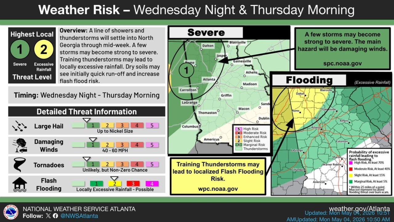
North Georgia Faces Level 1 Severe Risk and Level 2 Excessive Rainfall Threat Wednesday Night Into Thursday Morning With 40 to 60 MPH Winds and Flash Flood Risk From Training Thunderstorms
NORTH GEORGIA — The National Weather Service Atlanta has issued a weather risk outlook for Wednesday night through Thursday morning across North Georgia, combining a Level 1 Severe threat and a Level 2 Excessive Rainfall threat as a line of showers and thunderstorms settles into the region through mid-week. Damaging winds of 40 to 60 MPH are the primary severe hazard while training thunderstorms are expected to produce locally excessive rainfall and elevated flash flood risk across the area.
Detailed Hazard Breakdown Wednesday Night Into Thursday Morning
| Hazard | Threat Level | Detail |
|---|---|---|
| Large Hail | Level 1 of 5 | Up to nickel size |
| Damaging Winds | Level 1 of 5 | 40 to 60 MPH |
| Tornadoes | Non-zero | Unlikely but cannot be ruled out |
| Flash Flooding | Level 2 of 5 | Locally excessive rainfall possible |
Damaging Winds Are the Main Severe Hazard
The primary severe weather concern with this system is damaging winds reaching 40 to 60 MPH across North Georgia. A few storms within the line may become strong to severe as the system moves through the region Wednesday night into Thursday morning.
The severe risk outlined by the Storm Prediction Center covers a Marginal Risk Level 1 zone centered on Rome, Dalton, Gainesville and the Atlanta metro northward, including Carrollton, Canton and surrounding North Georgia counties.
Training Thunderstorms Create Flash Flood Risk on Dry Soils
A significant secondary concern is the flash flood risk developing from training thunderstorms — storms that repeatedly move over the same areas — leading to locally excessive rainfall accumulation. The flash flood probability map shows a Marginal Risk of at least 15 percent for excessive rainfall leading to flash flooding across a broad swath of North Georgia and into portions of northeast Georgia toward the South Carolina border.
Dry soils across the region will initially cause quick surface runoff rather than absorption, increasing flash flood potential even with moderate rainfall totals during the early stages of the event.
Timing and Impacted Cities
The threat window runs from Wednesday night through Thursday morning. Cities within or near the risk zone include Rome, Dalton, Gainesville, Canton, Carrollton, Atlanta, Athens, LaGrange, Griffin, Macon and Dublin.
Residents across North Georgia should monitor conditions closely Wednesday evening and have a plan in place for both severe weather and potential flash flooding before Thursday morning.
Stay with CabarrusWeekly.com for live updates on the North Georgia severe weather and flash flood risk Wednesday night through Thursday morning.