Louisiana, Mississippi, Alabama, Georgia, and Tennessee Face Up to 7 Inches of Drought-Busting Rain Over the Next 15 Days Through June 5 as Wettest Pattern in Months Takes Hold Across the Southeast
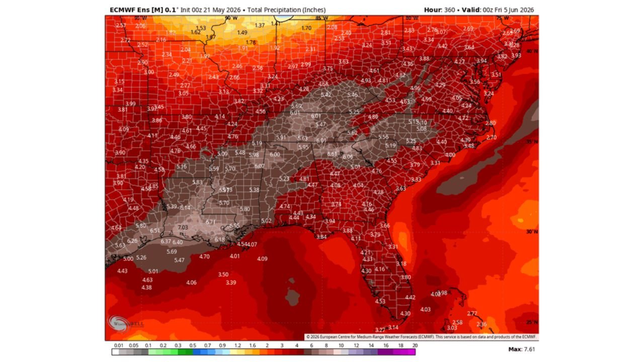
SOUTHEASTERN UNITED STATES — A very wet 15-day period is beginning today across the Southeast, with forecast precipitation data showing total rainfall of 5 to 7 inches across the core of the drought zone through Friday, June 5, 2026. The entire region is also running 2 to 5 inches above normal precipitation levels for this period, representing a historic and drought-busting moisture surge for an area that has been running critically dry for an extended stretch.
Total Rainfall Forecast Through June 5 by Region
| Region | Total Precipitation Forecast |
|---|---|
| Louisiana and Mississippi core | 6.37 to 7.03 inches |
| Alabama and Georgia | 5.70 to 6.14 inches |
| Tennessee and Mississippi corridor | 5.63 to 6.07 inches |
| Arkansas | 5.09 to 5.98 inches |
| North Carolina and South Carolina | 4.53 to 5.62 inches |
| Texas | 4.01 to 6.91 inches |
| Virginia and Maryland | 3.48 to 5.10 inches |
| Florida | 3.31 to 4.53 inches |
| Northeast corridor | 3.24 to 4.93 inches |
How Far Above Normal This Rainfall Is
The 15-day precipitation anomaly map through June 4, 2026 tells an equally dramatic story. Every portion of the Southeast is forecast to run significantly above normal for precipitation during this period:
| Region | Rainfall Above Normal |
|---|---|
| Louisiana and Mississippi | 4.22 to 5.69 inches above normal |
| Alabama and Georgia | 3.85 to 4.35 inches above normal |
| Tennessee and Kentucky | 3.40 to 4.29 inches above normal |
| Texas | 2.43 to 4.78 inches above normal |
| Carolinas | 2.47 to 3.46 inches above normal |
| Virginia and Maryland | 1.88 to 2.37 inches above normal |
| Florida | 1.75 to 2.66 inches above normal |
This Is the Drought Relief the Southeast Has Been Waiting For
The region entering this wet period has been running severe to extreme drought conditions across large portions of its entirety. A 15-day stretch delivering 5 to 7 inches of total rainfall with 2 to 5 inches above normal anomalies represents a significant and long-overdue shift in the precipitation pattern. While drought conditions of this magnitude cannot be fully erased in 15 days, this rainfall will make meaningful and substantial progress in reducing moisture deficits across the region.
Flooding Remains a Concern Alongside the Drought Relief
Despite the drought, repeated heavy rainfall events over a 15-day period carry serious flash flooding risk. As the ground saturates in the first days of this wet pattern, subsequent rounds of heavy rain will have nowhere to go, increasing the flash flood threat significantly. Residents across Louisiana, Mississippi, Alabama, Georgia, and Tennessee should monitor flood watches and warnings throughout this extended wet pattern.
Stay with CabarrusWeekly.com for daily rainfall, drought, and flood updates through June 5 across the Southeast.