South Florida Faces Near Record Atmospheric Moisture and 60 to 70 Percent Chance of Above Normal Rainfall From May 28 Through June 3 as Precipitable Water Hits 99th Percentile Across Sarasota, Cape Coral, Fort Lauderdale, and West Palm Beach
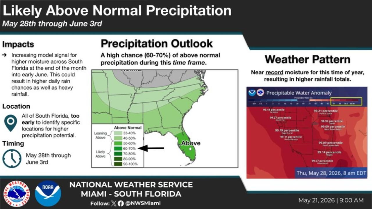
SOUTH FLORIDA — The National Weather Service Miami issued a significant precipitation outlook on May 21, 2026 at 9:00 AM, warning that near record atmospheric moisture arriving across South Florida at the end of the month could produce likely above normal precipitation from May 28 through June 3, 2026. The Climate Prediction Center is highlighting a 60 to 70 percent chance of above normal rainfall during this timeframe across all of South Florida.
Near Record Moisture Is the Key Driver
What makes this outlook particularly significant is the atmospheric moisture signal already being detected. Precipitable water anomaly readings across South Florida are showing values in the 99th percentile for this time of year at multiple locations simultaneously, meaning the atmosphere is carrying near record levels of moisture heading into the end of May:
| City | Precipitable Water Percentile |
|---|---|
| Sarasota | 99.44th percentile |
| Fort St. Lucie | 99.27th percentile |
| Cape Coral | 99.19th percentile |
| Bonita Springs | 99.11th percentile |
| West Palm Beach | 99.09th percentile |
| Fort Lauderdale | 99.14th percentile |
| Homestead | 99.07th percentile |
When atmospheric moisture readings sit at the 99th percentile, the environment is primed to convert that moisture into heavy and frequent rainfall whenever storm triggers are present.
The Full Outlook Details
| Factor | Details |
|---|---|
| Timing | May 28 through June 3, 2026 |
| Probability of Above Normal Rain | 60 to 70 percent |
| Category | Likely Above Normal |
| Location | All of South Florida |
| Specific Locations | Too early to identify |
What Residents Should Expect
The NWS Miami is clear that while the signal for above normal precipitation is strong, it is still too early to identify specific locations and exact rainfall totals within South Florida. What forecasters can say with confidence is that the combination of near record atmospheric moisture and a 60 to 70 percent probability of above normal rain will mean higher daily rain chances and the potential for heavy rainfall events across South Florida from May 28 into early June.
Prepare for a Very Wet End of May Into Early June
South Florida residents should plan for a significantly wetter than normal stretch beginning May 28. Flooding of low-lying areas, road flooding, and disruption to outdoor Memorial Day weekend activities are all possible as this near record moisture signal moves into the region.
Stay with CabarrusWeekly.com for daily updates on South Florida’s rainfall and flooding potential through early June.