West Texas and Oklahoma Face 80 MPH Wind Gusts, 2.5 Inch Hail, and Tornadoes This Afternoon and Evening Targeting Hereford, Plainview, Childress, Altus, Abilene, and Woodward
WEST TEXAS AND OKLAHOMA — A Slight Risk of severe storms is in effect across parts of west Texas and western Oklahoma this Friday afternoon and evening, May 22, 2026, with storms capable of producing damaging wind gusts up to 80 mph, large hail up to 2.5 inches in diameter, and a tornado or two with the strongest storm cells. The threat window is active right now and peaks through the evening hours.
Three Dangerous Threats With Today’s Storms
Every storm developing within the Slight Risk zone this afternoon carries the potential for all three hazards simultaneously:
- Damaging wind gusts up to 80 mph capable of destroying structures, downing trees, and flipping vehicles
- Large hail up to 2.5 inches capable of shattering windshields and causing significant property damage
- Tornadoes possible with the most robust and organized storm cells
Cities Directly Inside the Slight Risk Zone
The Slight Risk bullseye covers a wide corridor of west Texas and extends into western Oklahoma. Communities sitting directly inside the primary threat zone include:
- Hereford and Plainview, Texas
- Childress and Altus
- Haskell and Jayton, Texas
- Abilene, Texas
- Woodward, Oklahoma
The Broader Marginal Risk Zone
Surrounding the Slight Risk core, a Marginal Risk zone covers an even wider area including Clovis, Levelland, Lamesa, Odessa, Sterling City, Ballinger, Brownwood, Graham, Lawton, and Oklahoma City. Storms reaching these areas can still produce significant severe weather even outside the primary zone.
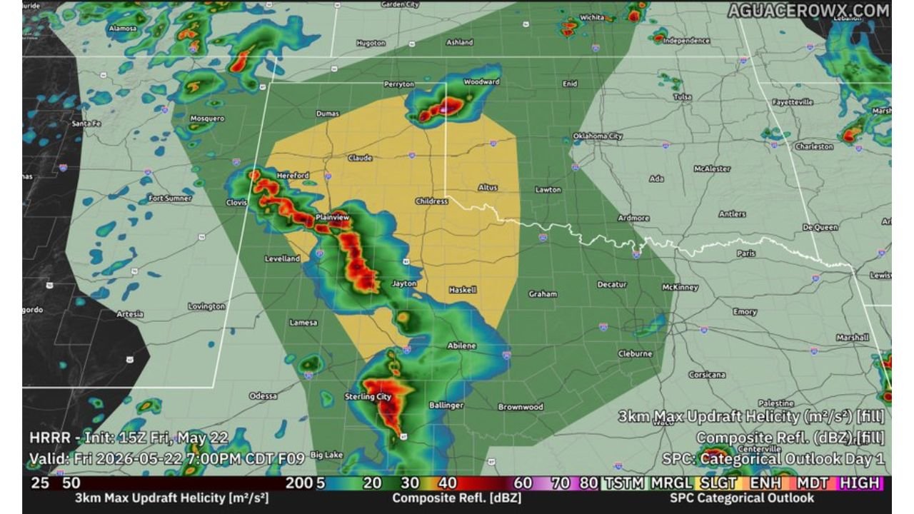
Radar Already Showing Active Storm Development
Radar valid at 7:00 PM CDT Friday is already showing intense storm cells firing across the west Texas corridor, with strong reflectivity values and significant updraft helicity values indicating rotating storm potential across the Slight Risk zone. This is an active and ongoing severe weather situation.
Protecting Vehicles and Property Must Happen Now
With hail up to 2.5 inches capable of destroying unprotected vehicles and wind gusts reaching 80 mph, anyone in the Hereford, Plainview, Childress, Abilene, and Woodward areas should move vehicles to covered parking immediately and secure all loose outdoor items before storms arrive.
Stay with CabarrusWeekly.com for live storm tracking and severe weather updates across west Texas and Oklahoma through Friday evening.