Illinois, Indiana, Arizona and Nevada Starved of Rain as Omega Block Grips the Nation for 7 Days
UNITED STATES — An omega block pattern is set to dominate the country’s weather for the next seven days, delivering a stark split across the nation. Near-zero rainfall is expected across the interior Midwest and Desert Southwest while the Gulf Coast and Southeast absorb heavy totals through Thursday, June 4, 2026.
The Omega Block Taking Control
An omega block is a high-pressure pattern that essentially freezes weather systems in place, named for its resemblance to the Greek letter. With this pattern locked in through the end of May and into early June, large portions of the central and western U.S. will see little to no meaningful precipitation. It is an unusual setup heading into the meteorological summer season.
Where Rain Goes to Zero
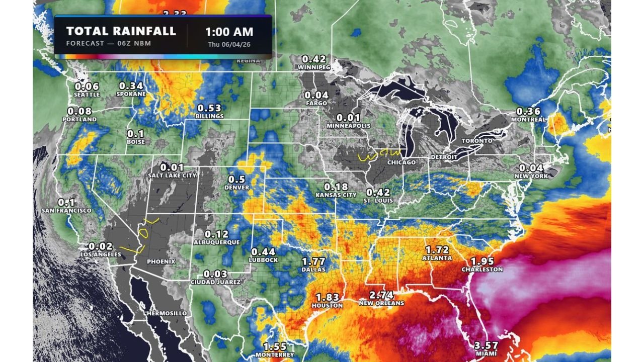
The 7-day total rainfall forecast makes the dry zone impossible to miss. Across the interior plains, Great Lakes, and Desert Southwest, totals are nearly nonexistent:
| City | 7-Day Forecast Total |
|---|---|
| Minneapolis | 0.01 in |
| Chicago | Trace |
| Detroit | Trace |
| Kansas City | 0.18 in |
| Salt Lake City | 0.01 in |
| Phoenix | 0.00 in |
| Los Angeles | 0.02 in |
| Fargo | 0.04 in |
| St. Louis | 0.42 in |
The gray zones blanketing the central plains, Great Lakes, and Desert Southwest on the forecast map confirm what the numbers show. This region is essentially getting shut out of rainfall through early June.
Where the Rain Is Actually Going
While the interior dries out, the Gulf Coast and Southeast are on the receiving end of significant moisture. Forecast totals through June 4 include:
| City | 7-Day Forecast Total |
|---|---|
| Miami | 3.57 in |
| New Orleans | 2.74 in |
| Charleston | 1.95 in |
| Houston | 1.83 in |
| Dallas | 1.77 in |
| Atlanta | 1.72 in |
The Pacific Northwest also sees some activity, with Billings at 0.53 inches and Spokane at 0.34 inches, tied to a separate western disturbance.
An Odd End to May
Meteorologists are flagging this as an unusual close to May. The omega block’s grip means that areas already running dry will extend their rainfall deficits further, while the Southeast absorbs yet more rain. The split is expected to persist into the first days of June with no major pattern change on the immediate horizon.
Stay with CabarrusWeekly.com as the omega block evolves and updated rainfall forecasts come in through early June.