Tuesday Evening Wintry Mess Could Trigger Snow, Sleet, and Freezing Rain Across Kentucky and Nearby Regions
KENTUCKY — A messy and highly uncertain winter weather setup is shaping up for Tuesday afternoon through late night, with rain, sleet, freezing rain, and snow all possible across much of Kentucky, according to the latest forecast data. Meteorologists warn that critical transition lines will likely not fully settle until just hours before the event, making precise impacts difficult to pin down.
Sharp North-South Divide Expected in Precipitation Types
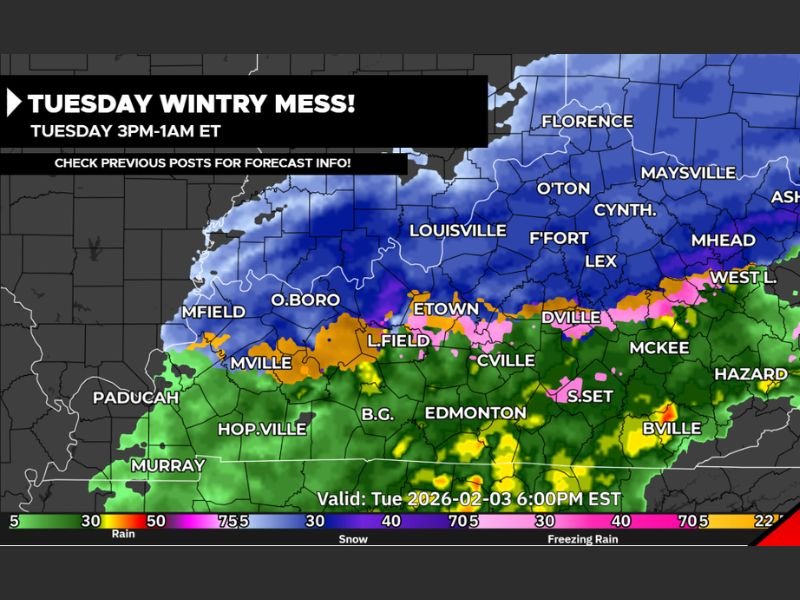
Forecast imagery shows a clear precipitation gradient across Kentucky, with snow dominating northern sections, while sleet, freezing rain, and plain rain impact central and southern areas.
- Northern Kentucky, including areas near Florence, Maysville, Lexington, and Ashland, is currently favored for mostly snow
- Central Kentucky, including Louisville, Frankfort, and Elizabethtown, sits near the rain–snow–sleet boundary
- Southern and southeastern Kentucky, including Bowling Green, Hazard, McKee, and Somerset, is more likely to see rain mixing with sleet or freezing rain
Small shifts in temperature could dramatically change outcomes.
Snow Totals and Ice Accumulation Still in Flux
Where snow remains dominant, 3 to 6 inches of accumulation is possible. Areas caught in a mixed zone could see 2 to 4 inches of snow, combined with sleet and freezing drizzle, which poses a greater travel risk despite lower snow totals.
Forecasters emphasize that icing may become the bigger concern in transition zones, especially if freezing rain persists for several hours.
Timing: Tuesday Afternoon Through Early Wednesday
The highest impact window is expected Tuesday between 3 PM and 1 AM ET, with precipitation intensifying during the evening hours as colder air presses southward. Overnight cooling could allow rain to change to sleet or snow, particularly across central Kentucky.
Anything that melts earlier in the day could refreeze overnight, worsening road conditions.
Travel and Safety Concerns
With uncertainty still high, residents are advised to:
- Avoid unnecessary travel Tuesday night
- Prepare for rapidly changing road conditions
- Monitor updates closely, especially if living near transition zones
- Be ready for last-minute forecast changes
Meteorologists caution that winter systems like this often don’t fully resolve until the night before, meaning confidence will increase closer to onset.
CabarrusWeekly will continue monitoring updated model data and provide refined coverage as precipitation lines become clearer.