Arctic Front Sparks Snow Squalls Across Massachusetts, Connecticut and Rhode Island as Bitter Wind Chills Plunge Below Zero
UNITED STATES — A powerful Arctic air mass is surging into the Northeast this weekend, setting up a fast-moving but potentially dangerous winter weather event across Massachusetts, Connecticut, and Rhode Island, where snow squalls, narrow heavy bands, and extreme cold will combine to create hazardous travel conditions from Friday night into Saturday.
Forecast data shows a classic high-impact setup where snowfall totals may vary sharply over short distances, depending on where narrow bands of heavier snow develop as the Arctic front moves through southern New England.
Snow Timeline and Setup Heading Into Saturday
Snow showers are expected to develop after 6 p.m. Friday as low pressure redevelops south of Long Island. These snow showers will continue through Saturday evening, with the highest impact window early Saturday morning as Arctic air deepens over the region.
A key uncertainty in the forecast is the placement of an inverted trough, which could shift slightly east or west. That shift will determine where the heaviest snowfall bands set up, creating the potential for localized higher totals in otherwise lighter snowfall areas.
Expected Snowfall Totals and Impact Zones
Most of southern New England is expected to receive light to moderate snowfall, but select areas could see significantly higher totals if heavier banding develops.
Forecast guidance indicates:
- Trace to 1 inch in areas dominated by scattered snow showers
- 1 to 3 inches across much of southern New England
- Localized 3 to 6 inches in narrow corridors where snow bands persist
Areas highlighted for the highest snow potential include:
- The Berkshires of western Massachusetts, extending into northwestern Connecticut
- Eastern coastal Massachusetts, including Cape Cod and nearby coastal zones
- Portions of eastern Connecticut and Rhode Island, depending on trough alignment
Some snow bands may briefly produce intense snowfall rates, rapidly reducing visibility and covering roads in a short time.
Snow Squalls Could Create Sudden Whiteout Conditions
Forecasters caution that this system may behave more like a convective snow event, with short-lived but intense snow squalls rather than steady snowfall.
These squalls could bring:
- Rapid drops in visibility
- Snow-covered roads within minutes
- Dangerous driving conditions even where total snowfall is modest
This makes the event particularly hazardous for early Saturday travel.
FeBRRRuary Cold Arrives With Dangerous Wind Chills
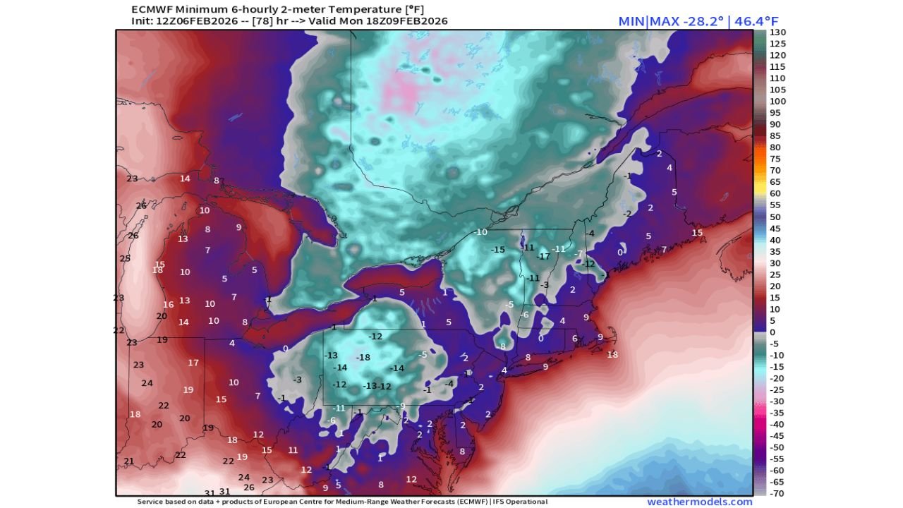
Behind the snow, the Arctic air mass will deliver one of the coldest airmasses of the season so far across New England.
Wind chill projections show:
- 10 to 15 below zero for much of the region this weekend
- 20 to 30 below zero in the coldest locations beginning Saturday morning
These conditions increase the risk of frostbite and hypothermia, especially for anyone stranded or exposed outdoors for extended periods.
Broader Winter Pattern Shows No Immediate Relief
The cold pattern extends well beyond New England. Additional winter indicators across the eastern United States highlight the strength of this Arctic regime.
Lake Erie is shown to be approximately 96 percent ice-covered, with projections suggesting it could soon reach near-total ice coverage, a relatively rare occurrence on long-term climate scales.
Meanwhile, parts of the Ohio Valley and western Pennsylvania are monitoring potential record-level cold, with Pittsburgh specifically flagged for a sharp temperature collapse under ideal radiational cooling conditions early next week.
Winter Impacts Linger in the South After Ice Storm Fern
While New England braces for snow and cold, winter recovery continues elsewhere. More than 16,000 customers remained without power in parts of northern Mississippi as of February 7, 2026, more than two weeks after Winter Storm Fern.
Communities including Batesville, Oxford, Water Valley, Ripley, Middleton, and Burnsville experienced ice accretion exceeding one inch, causing extensive infrastructure damage that requires prolonged repair efforts.
What to Watch Next
Beyond this weekend, long-range signals are monitoring another potential winter weather window around February 14–16, though forecasters stress that confidence remains low at this stage.
For now, residents across southern New England should prepare for rapidly changing snow conditions, extreme cold, and dangerous wind chills through Saturday.
What are conditions like in your area? Share your experience and stay updated with more regional weather coverage at CabarrusWeekly.com.