New England Snow Pattern Turns Active as Multiple Systems Line Up, With Blizzard-Like Conditions Possible Late Week
UNITED STATES — A highly active winter pattern is unfolding across the Northeast as multiple snow-producing systems line up over the next several days, with southern and eastern New England facing repeated snowfall chances and the potential for a much stronger storm late in the week.
Short-term model guidance confirms that the first round of snow arrives tomorrow, with a widespread light to moderate accumulation expected across much of southern New England. Current projections support a general 1–3 inch snowfall, with some localized areas pushing 2–4 inches, especially where banding becomes more persistent. This initial event is driven by a developing convergent snow band forming as a surface front interacts with an inverted trough, a setup already evident on high-resolution guidance.
The most organized snowfall during this first system is expected to develop through the afternoon as lift strengthens and snow bands accelerate eastward. Coastal areas may see additional enhancement from ocean influence, particularly across northeastern Massachusetts.
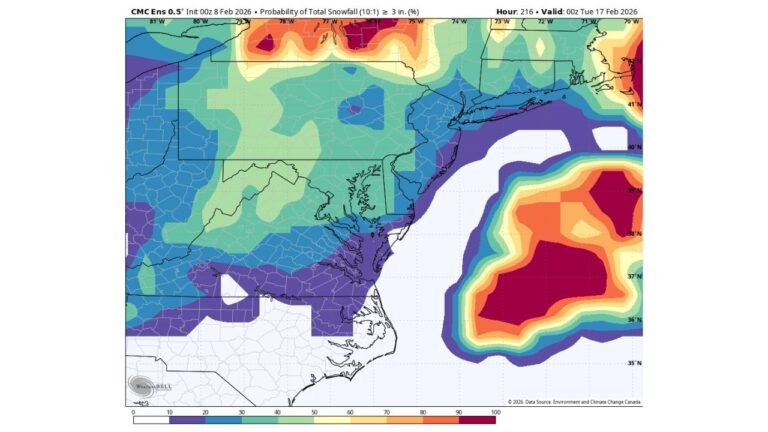
Coastal Enhancement Raises Totals From Cape Ann to the New Hampshire Seacoast
High-resolution ensemble output highlights the best chance for higher snowfall totals from Cape Ann northward through the New Hampshire Seacoast, where ocean-enhanced snowfall may boost accumulations beyond surrounding inland areas. These locations sit closest to the strongest low-level forcing and colder air aloft, allowing snow rates to briefly intensify.
While inland locations across southern New England will still see accumulating snow, totals are expected to taper gradually westward as forcing weakens away from the coast.
Additional Snow Chances Continue Midweek
The active pattern does not stop with the first system. Guidance indicates another round of light snow Tuesday night into Wednesday, with scattered accumulations possible as another disturbance moves through the region. Snowfall with this system appears lighter and more scattered, but enough to create slick travel conditions in spots.
There is also growing support for yet another snow chance late in the week, potentially Friday, though confidence on exact placement and intensity remains lower at this time.
Bigger Story Emerges for Valentine’s Day Weekend
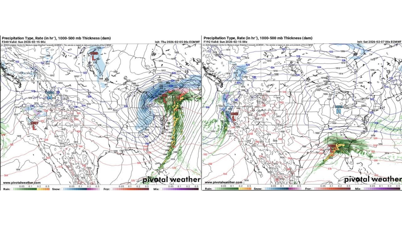
The most notable signal in the data is tied to a strong late-week storm system, increasingly evident on European model runs. Upper-air analysis at the 500 mb level shows a powerful system developing in the same general pattern family as the historic 1978 blizzard, though early indications suggest this storm may track slightly farther east.
Even with a more easterly track, New England remains well-positioned for a formidable winter storm, featuring strong winds, bitter cold, and the potential for blizzard-like conditions from late Friday into Saturday. Snowfall intensity, wind-driven blowing snow, and rapidly deteriorating travel conditions are all possible outcomes if the system continues to evolve as currently depicted.
Snow Showers Possible Sunday, Including the Carolinas
Behind the primary systems, guidance also suggests midday snow showers on Sunday, especially dropping in from the northwest. These showers would be short-lived, lasting only a few hours, but could produce a quick coating of snow, mainly on elevated surfaces, grass, and untreated roads.
This includes portions of the southern Appalachians and parts of the Carolinas, where a narrow band of snow showers could briefly impact travel despite no major storm expected.
Pattern Remains Active Heading Deeper Into February
Long-range guidance reinforces the idea that this winter pattern is far from over. As longer-range forecasts compress into shorter timeframes, confidence continues to grow that additional winter systems are likely, keeping snow chances in play well beyond this week.
For now, residents across New England — and parts of the Southeast — should remain prepared for repeated winter impacts, with the late-week storm standing out as the most significant threat in the current forecast cycle.
CabarrusWeekly.com will continue tracking updates as confidence increases and details become clearer.