Southern New England Snowstorm Signal Emerges as Ocean Enhancement and Arctic Air Combine to Create Localized Heavy Bands
SOUTHERN NEW ENGLAND — Meteorologists are closely monitoring a complex winter weather setup that could produce a highly localized snowstorm across parts of Southern New England, driven by a subtle but impactful interaction between ocean moisture, incoming cold air, and tightening pressure gradients.
Follow the Isobars: Why Precipitation Placement Matters
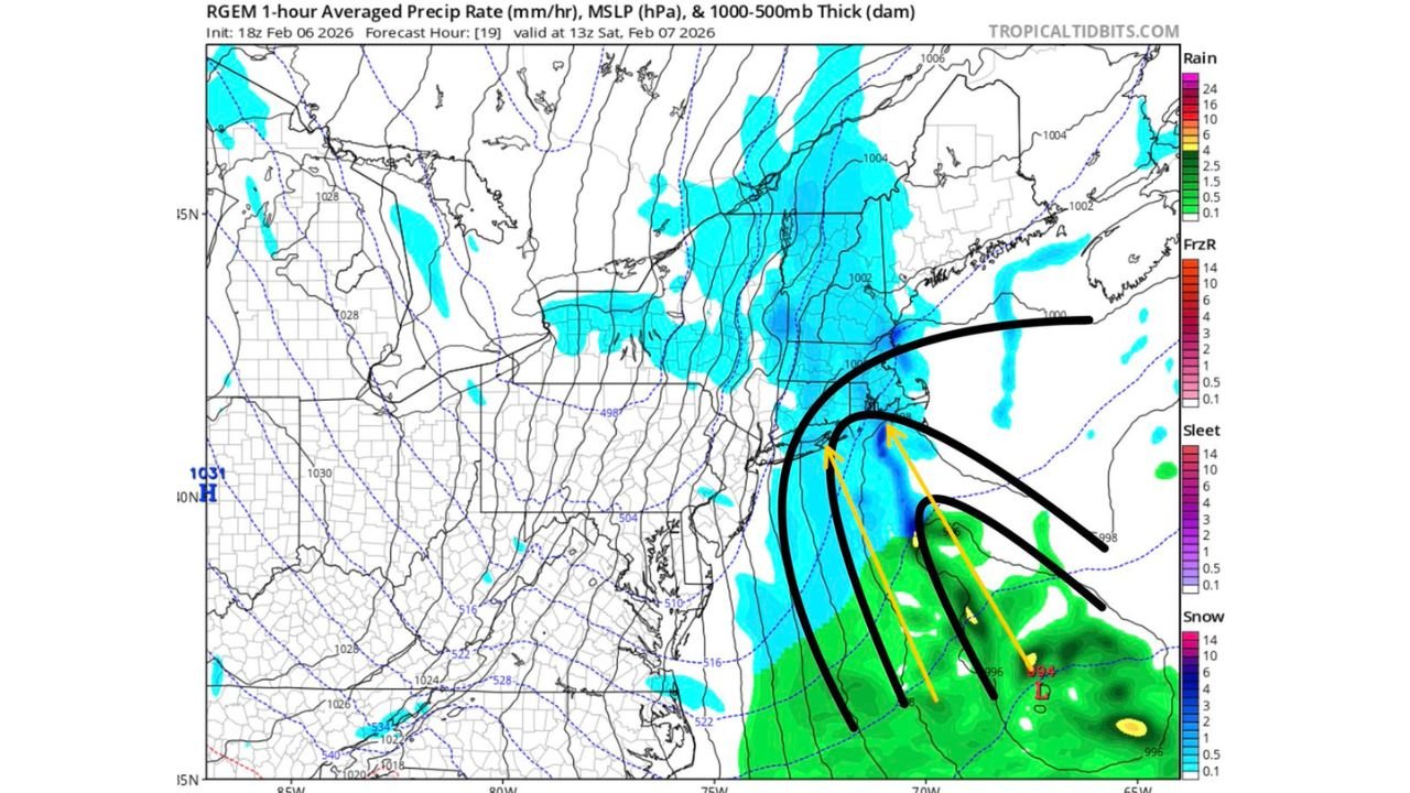
Forecast guidance shows precipitation closely aligning with surface isobars, a classic signal that snowfall will follow zones of strongest pressure convergence rather than spreading evenly across the region. This setup favors narrow but intense snowfall bands, where small shifts in wind direction could dramatically change totals over short distances.
Sneaky IVT Adds Moisture Without a Major Storm Signal
An Integrated Vapor Transport (IVT) feed is present in this system, supplying moisture from the Atlantic. While this IVT is not particularly strong, it is sufficient to enhance snowfall when combined with other factors. Because it lacks the signature of a classic coastal storm, models may underestimate its impact, especially in short-range guidance.
Cold Air Advection and Ocean Enhancement Create a “Triple-Point” Effect
As cold air advection pushes in from the west, it collides with ocean-modified air along the New England coastline. This interaction, paired with subtle mid-level forcing, creates a figurative “triple-point” where snowfall rates can rapidly intensify. These features are notoriously difficult for models to resolve in real time, increasing forecast uncertainty.
Localized Snowstorm Potential for Southern New England
The result of this setup is a localized snowstorm threat focused on Southern New England, with sharp gradients between heavy snow and lighter accumulations. Some areas may experience subsidence nearby, leading to lower totals just miles away from heavier bands. This makes precise forecasting challenging and increases the risk of surprise accumulations.
Areas Watching Closely: Long Island, Connecticut, and Western Massachusetts
Residents in Long Island, Connecticut, and parts of western Massachusetts should monitor trends carefully. While coastal enhancement favors areas closer to the Atlantic, orographic lift in the Berkshires may provide a modest boost to snowfall in higher terrain, even as surrounding valleys see less consistent coverage.
Why Models May Struggle With This Setup
Because this event relies on mesoscale interactions rather than a dominant storm center, guidance may continue to shift until the system is underway. Forecasters are watching real-time observations to better pinpoint where snow bands ultimately set up.
If you’re in the affected region, conditions may vary dramatically depending on location. Share what you’re seeing on the ground and stay tuned for continued updates from CabarrusWeekly.com as this evolving winter pattern unfolds.