Rhode Island Snow Bands Intensify as Warning Decisions Lag Behind Rapidly Developing Heavy Snowfall
RHODE ISLAND AND SOUTHERN NEW ENGLAND — A rapidly evolving snow event across Rhode Island, eastern Connecticut, and nearby southern New England is drawing attention as heaviest snow bands begin to intersect areas already exceeding warning-level snowfall, even as parts of the region remain without a Winter Storm Warning.
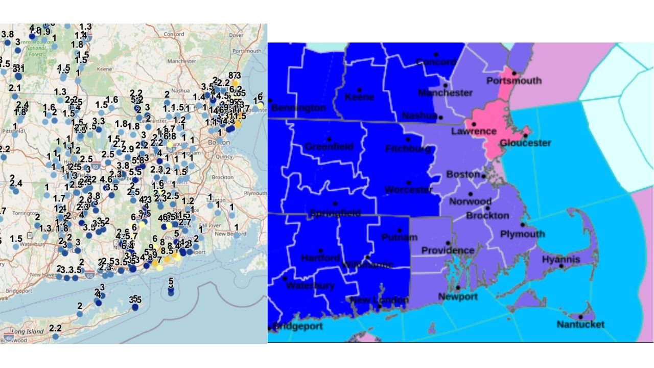
Observed Snowfall Already Exceeds Criteria in Southern Rhode Island
Snowfall reports across southern Rhode Island and portions of eastern Connecticut show accumulations already meeting or exceeding local warning thresholds, with several observing sites reporting multiple inches in a short time window. These totals are occurring ahead of the most intense banding now developing, suggesting impacts are already underway before peak forcing arrives.
Developing Band Intersection Signals Higher Short-Term Rates
Radar and surface observations indicate a band intersection zone forming over Rhode Island, where multiple snow bands are converging. This setup is notorious for producing brief but intense snowfall rates, often overwhelming treatment efforts and rapidly deteriorating travel conditions even outside traditional storm footprints.
Inconsistent Criteria Application Across Southern New England
The current warning configuration raises questions as Rhode Island remains unwarned while parts of southeastern Massachusetts share the same criteria, despite little or no snow reported there so far. This contrast highlights how mesoscale banding events can outpace static forecast zones, especially when snowfall is driven by localized dynamics rather than a uniform storm shield.
Why This Setup Is Difficult for Warning Timing
This event is being driven by narrow, fast-developing snow bands, not a classic widespread winter storm. Such setups often cause forecast lag, where warnings are issued reactively rather than proactively. By the time confidence increases, snowfall rates may already be peaking, particularly in compact regions like Rhode Island.
What Residents Should Expect Over the Next Several Hours
As banding continues to organize, additional heavy snow is likely where intersections persist, especially across central and southern Rhode Island and adjacent eastern Connecticut. Areas just outside these bands may see much lower totals, creating sharp accumulation gradients over short distances.
Residents are urged to focus on real-time conditions rather than warning maps alone, as snowfall intensity may change rapidly from town to town. If you’re experiencing rapidly worsening conditions, share what you’re seeing and stay connected with ongoing coverage from CabarrusWeekly.com as this evolving snow event continues to unfold.