West Coast Weather Pattern Flips After Month-Long Lull, Bringing Widespread Rain and Feet of Mountain Snow to California, Nevada, and Utah
WESTERN UNITED STATES — After a relatively quiet stretch lasting much of the past month, the West Coast weather pattern is undergoing a significant shift early this week, opening the door for multiple storm systems to deliver widespread rain, mountain snow, and improving moisture conditions across large portions of California, Nevada, and Utah.
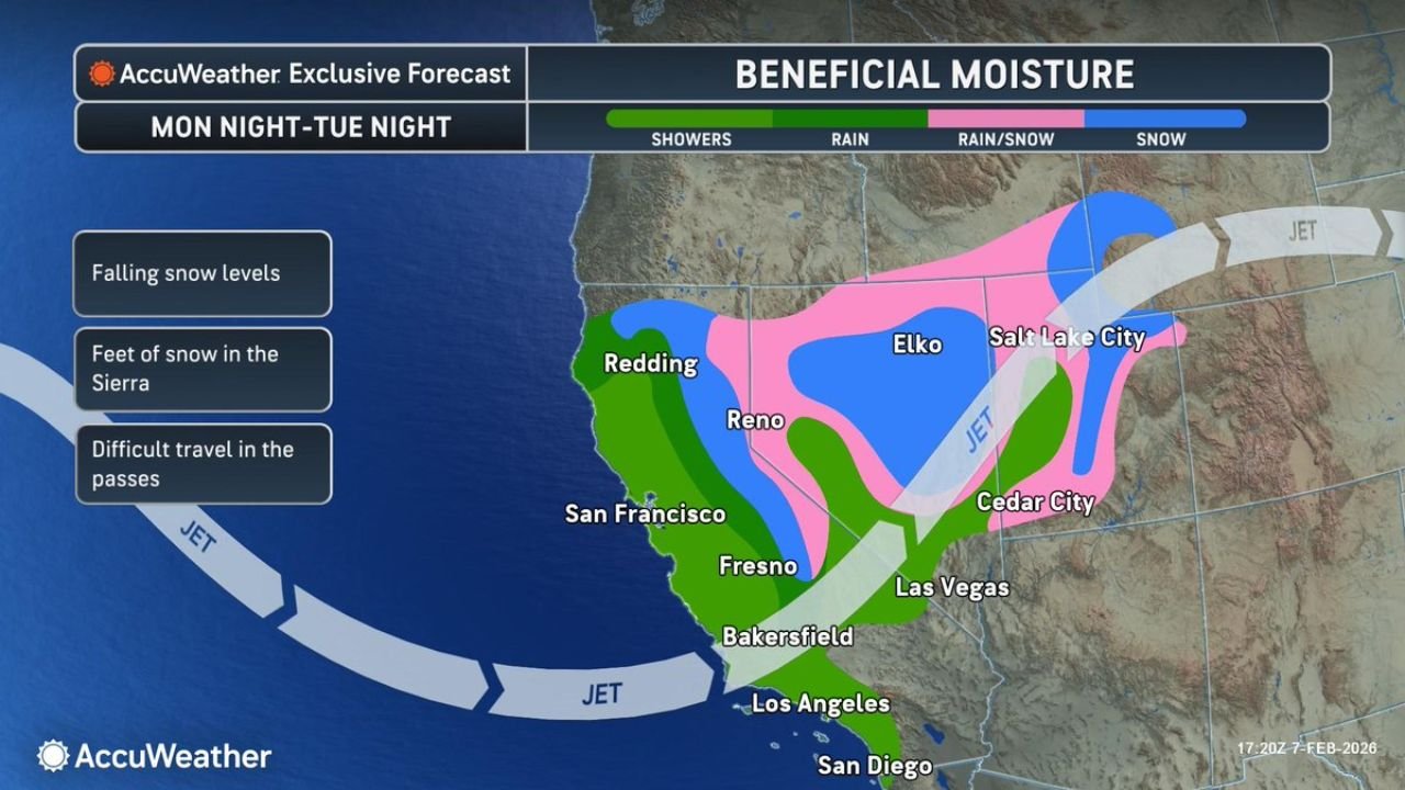
Pacific Jet Stream Re-Engages the West Coast
Forecast data shows the Pacific jet stream re-establishing itself into the western United States, ending the prolonged lull that limited storm activity. This renewed flow will steer periods of showers and steady rain into coastal and valley locations, while colder air aloft supports accumulating snow in higher elevations.
Beneficial Rainfall Returns to California Valleys and Cities
Lower elevations across California, including areas from San Diego and Los Angeles northward through Bakersfield, Fresno, San Francisco, and Redding, are expected to see beneficial rainfall. While this is not a single high-impact flooding event, repeated rounds of rain will help restore soil moisture and improve drought conditions, especially in central and northern parts of the state.
Snow Levels Fall as Sierra Nevada Sees Heavy Accumulation
As colder air moves inland, snow levels will fall, allowing heavy mountain snow to develop across the Sierra Nevada. Forecast guidance indicates feet of snow are possible in the highest elevations, particularly near and east of the Sierra crest, including areas around Reno.
These accumulations are expected to significantly improve snowpack but will also create hazardous travel conditions through mountain passes.
Interior West Impacted by Rain-Snow Transition Zone
Farther inland, a broad rain-snow transition zone is expected to set up across Nevada and Utah, impacting areas such as Elko, Cedar City, and Salt Lake City. These locations may experience periods of mixed precipitation, with snow becoming more dominant at higher elevations and during overnight hours.
Travel Concerns Grow Across Mountain Passes
With falling snow levels and increasing storm coverage, difficult travel is likely through mountain passes across the Sierra Nevada and parts of the interior West. Rapid changes in conditions may occur as storms move through, particularly during heavier snowfall periods.
A Clear Shift From the Recent Quiet Pattern
This developing setup marks a notable departure from the quiet pattern of recent weeks, signaling a return to more seasonable winter activity across the West. While impacts will vary by elevation and location, the overall theme favors beneficial moisture paired with mountain travel challenges.
Residents and travelers across the western United States are encouraged to monitor local forecasts closely as storms move through the region. Share conditions from your area and follow continued coverage from CabarrusWeekly.com as this active pattern unfolds.