New York City Braces for Coldest Night of the Winter as Central Park Forecast to Drop to 5°F With Dangerous Wind Chills
NEW YORK CITY, NEW YORK — A surge of Arctic air is set to deliver the coldest night of the winter so far to New York City, with forecasters expecting temperatures to fall below the season’s previous low and wind chills to reach dangerous levels through Sunday.
Central Park Forecast to Set New Winter Low
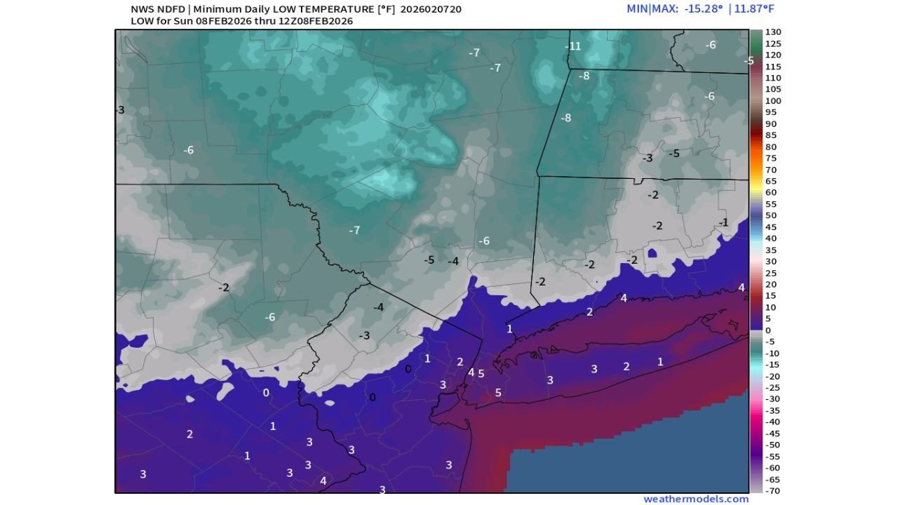
The coldest temperature recorded so far this winter at Central Park has been 9°F, but updated forecasts indicate that low will likely be surpassed overnight. The National Weather Service is projecting a minimum temperature near 5°F, marking the coldest reading of the season for the city if verified.
Temperature guidance shows the coldest air settling in during the pre-dawn hours, when radiational cooling and diminishing cloud cover allow readings to drop rapidly.
Extreme Cold Warning in Effect for Wind Chills
While actual air temperatures are expected to bottom out near 5°F, wind chills will feel significantly colder, with values forecast between −15°F and −20°F. Because of this, an Extreme Cold Warning remains in effect until 1 p.m. Sunday.
These wind chill values can cause frostbite on exposed skin in as little as 30 minutes, particularly during the overnight and early morning hours.
Arctic Air Mass Driving the Cold
This cold snap is being driven by a strong Arctic high-pressure system pushing southward into the Northeast. The air mass is exceptionally dry and dense, allowing temperatures to plunge efficiently once winds ease.
Minimum temperature maps show widespread sub-zero readings across interior New York, New England, and the northern Mid-Atlantic, with the coldest values focused inland while coastal areas remain slightly milder due to ocean influence.
How This Compares to the Rest of Winter
Although New York City has experienced multiple cold stretches this season, tonight’s setup stands out due to the combination of low temperatures and prolonged wind exposure. The expected low would represent the coldest night of the winter, even compared to earlier Arctic outbreaks.
Meteorologists note that late-season Arctic intrusions often bring sharper overnight lows, even when daytime temperatures recover modestly.
Safety Concerns as Cold Peaks Overnight
Residents are urged to take precautions, including protecting exposed skin, checking on vulnerable individuals, and safeguarding pets and plumbing. Even brief exposure during peak cold hours can be hazardous under these conditions.
If you’re experiencing the cold firsthand or noticing rapidly falling temperatures in your area, share your observations and follow continued winter weather coverage at CabarrusWeekly.com.