Endgame Winter Storm Takes Shape Across Eastern Massachusetts as Cold Front Advances, Coastal Snow Bands Intensify, and Icing Risk Expands South
EASTERN MASSACHUSETTS — The final phase of a winter storm is unfolding across eastern Massachusetts as a strong cold front pushes southward, enhancing coastal snowfall, tightening snow bands, and introducing increasing icing concerns as temperatures fall.
Northern Shutoff Strengthens Coastal Snowfall
As the system begins to shut off from the north, snowfall is becoming increasingly concentrated farther south and east. This cutoff is enhancing coastal snow rates, particularly from the Boston metro area toward Cape Cod, as moisture is forced to focus along the remaining convergence zone.
Radar imagery shows snow becoming more organized near the coast while areas farther inland begin to see more variability in intensity as the storm transitions into its endgame.
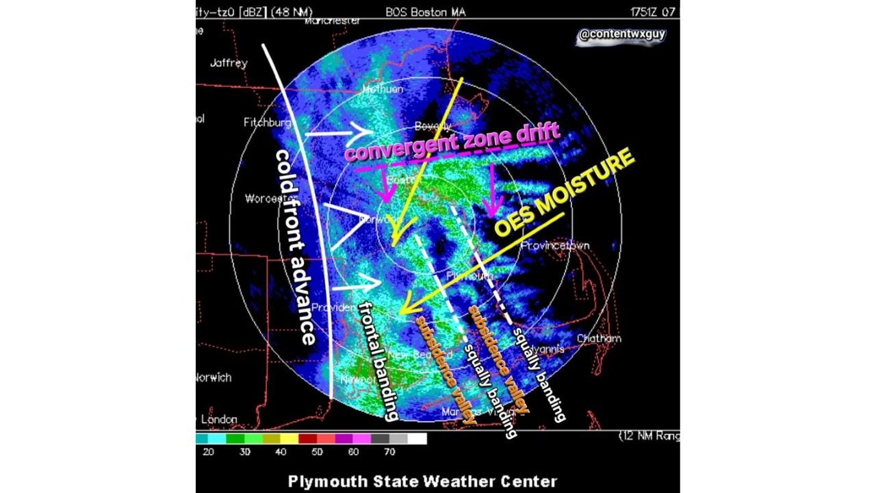
Convergent Zone Drift Drives Heavy Snow Banding
One of the most prominent features on radar is a drifting convergent zone, which is acting as a focal point for intense snowfall. As this zone slides south and east, it is producing strong frontogenetic banding, capable of brief but heavy snowfall rates where it stalls.
Communities caught beneath this band are experiencing rapid accumulation, while areas just outside of it see noticeably lower totals, a classic hallmark of late-stage winter storms.
OES Moisture Feeds Persistent Snow Near the Coast
Ocean-Effect Snow (OES) moisture continues to feed into the system from the east, reinforcing snowfall across coastal Massachusetts. This added moisture is helping sustain narrow but intense snow bands, particularly near Plymouth, Provincetown, and adjacent coastal zones.
The interaction between OES moisture and the advancing cold front is allowing snowfall to persist longer than it otherwise would as the storm begins to weaken aloft.
Subsidence Valleys Create Sharp Snowfall Gradients
Despite strong banding, radar analysis also reveals subsidence valleys, where sinking air temporarily suppresses precipitation. These zones are creating sharp cutoffs in snowfall over relatively short distances, leading to uneven totals across eastern Massachusetts.
Locations under sustained banding are seeing steady snow, while nearby areas may experience lighter snow or intermittent lulls as these subsidence features rotate through.
Cold Front Pushes South, Icing Risk Increases
The advancing cold front is ushering in colder air from the north, causing surface temperatures to fall rapidly. As this colder air undercuts lingering moisture, icing is becoming an increasing concern, especially in areas where precipitation transitions from snow to a brief mix or freezing drizzle.
Road conditions may deteriorate quickly as temperatures drop, particularly during the latter stages of the storm.
Storm Winds Down but Impacts Continue
While the storm is clearly entering its final phase, impacts are far from over. Localized heavy snow bands, coastal enhancement, and icy conditions will continue to pose hazards through the remainder of the event, especially for travel.
If you’re experiencing rapidly changing snow intensity or icy conditions where you live, we want to hear from you. Share your local observations and stay updated with ongoing winter weather coverage at CabarrusWeekly.com.