United States Thaw Builds as Warmer-Than-Normal Temperatures Expand Across North Carolina, Florida, Texas, and the Midwest While the West Stays Cool
NORTH CAROLINA — A broad and increasingly confident warm-weather signal is taking shape across the United States, with forecast outlooks showing above-normal temperatures spreading across most states east of the Rockies, including North Carolina, Florida, Texas, and much of the Midwest, through at least the next two weeks.
Warmer-Than-Normal Pattern Locks In Across Much of the U.S.
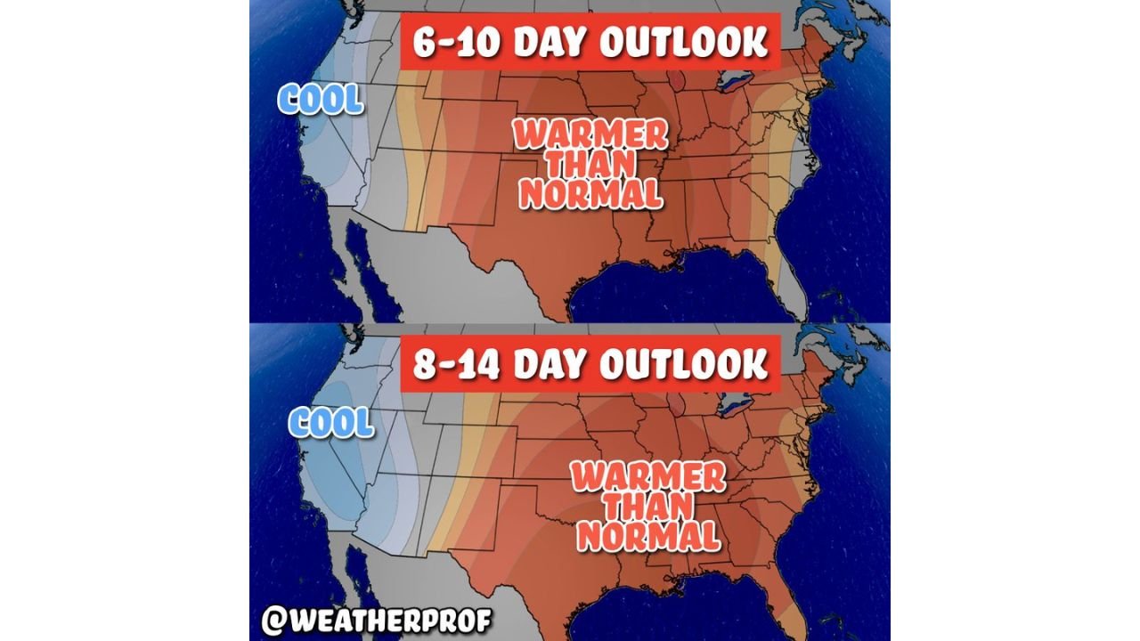
Both the 6–10 day and 8–14 day outlooks indicate a dominant warm pattern stretching from the Southern Plains through the Southeast, Ohio Valley, and Mid-Atlantic. This includes large portions of Texas, Louisiana, Mississippi, Alabama, Georgia, the Carolinas, Tennessee, Kentucky, and the Midwest, where temperatures are expected to remain consistently above seasonal averages.
Rather than brief warm spikes, the data supports a sustained thaw, signaling a meaningful shift away from recent colder weather episodes.
North Carolina and the Southeast Enter a Prolonged Mild Stretch
North Carolina sits firmly within the warmer-than-normal zone for both forecast periods. This points to milder daytime highs, fewer cold mornings, and reduced frost potential, especially across central and eastern parts of the state.
The broader Southeast, including South Carolina, Georgia, and Alabama, follows a similar trend, suggesting a gradual transition toward early spring-like conditions rather than volatile temperature swings.
Florida Sees One of the Strongest Warm Signals
Florida stands out in the data as one of the most reliable warm zones nationwide. Forecasts show warmth building and persisting across the entire state, with little indication of significant cold intrusions through the outlook period.
This pattern favors stable, comfortable temperatures, reinforcing the idea that winter is steadily loosening its grip across the Deep South.
Midwest and Central States Also Trend Mild
The warm signal extends northward into Missouri, Illinois, Indiana, Ohio, and parts of the Upper Midwest, suggesting above-average temperatures will reach well beyond the South. While not as warm as the Southeast, these states should still see a noticeable break from winter cold.
This widespread coverage highlights the strength and scale of the pattern shift.
Western States Remain the Primary Exception
In contrast, the western United States, including California, Oregon, Washington, Nevada, and the Rocky Mountain states, remains cooler than normal. Higher elevations continue to favor chilly conditions and ongoing snowfall, particularly beneficial for ski resorts and mountain snowpack.
This west-east split allows winter weather to persist where it’s most needed for water resources, while much of the rest of the country warms.
What This Means Going Forward
If the outlook holds, the eastern two-thirds of the United States will experience a steady and sustained thaw through late February, reducing cold-weather impacts and signaling a seasonal transition. At the same time, winter remains active in western mountain regions, creating a balanced national pattern.
CabarrusWeekly.com will continue monitoring temperature trends and long-range outlooks. Readers are encouraged to share how conditions are changing in their state and stay connected with CabarrusWeekly.com for continued weather updates.