Expanding Late-February Severe Weather Signal Emerges Across the Lower Mississippi and Tennessee Valleys
UNITED STATES — Long-range atmospheric guidance is beginning to highlight a developing window for increased severe weather potential across parts of the southern United States as February moves toward its final week.
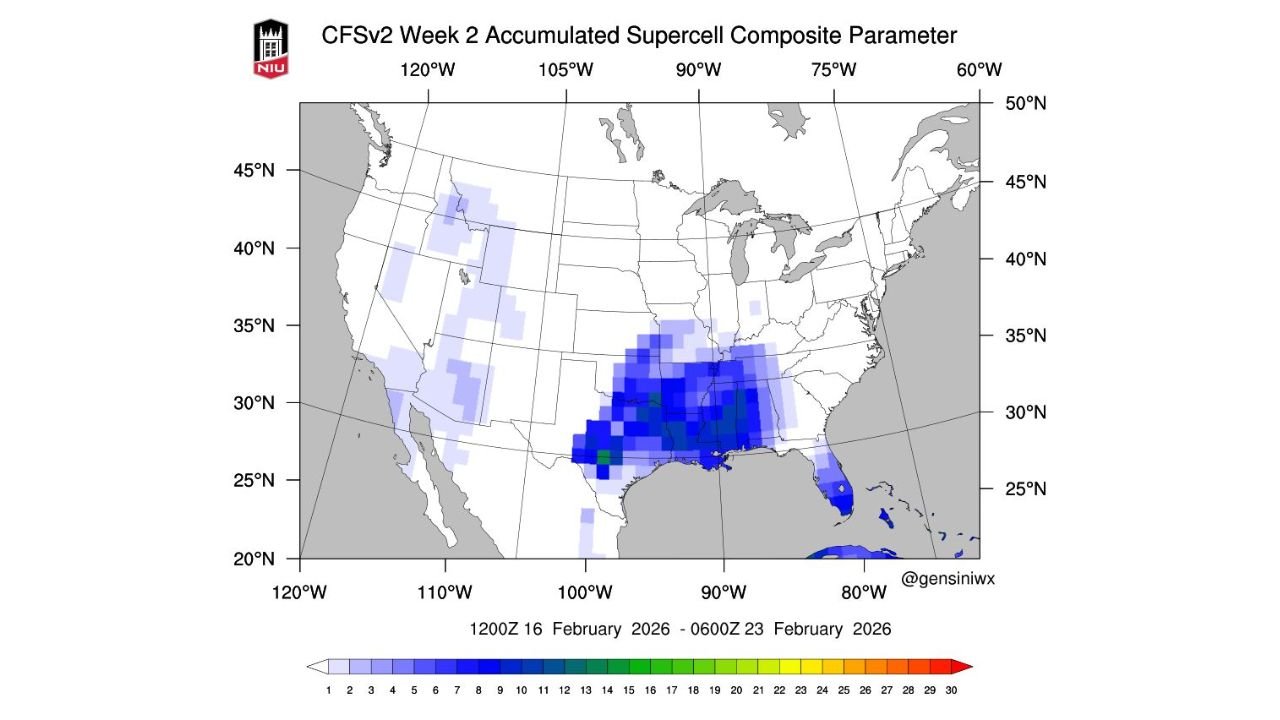
CFSv2 Data Highlights Elevated Supercell Environment
The latest CFSv2 Week 2 Accumulated Supercell Composite Parameter shows a concentrated signal across the Lower Mississippi Valley and Tennessee Valley, indicating an environment that could become more favorable for organized thunderstorms during the February 16–23 timeframe.
The strongest values are clustered from eastern Texas through Louisiana, Mississippi, Alabama, and into Tennessee, suggesting a broad region where atmospheric ingredients may align more frequently than normal for late February.
What the Supercell Composite Parameter Indicates
This parameter does not forecast specific storms. Instead, it highlights large-scale atmospheric conditions that historically support rotating thunderstorms when storms do develop. Elevated values typically reflect a combination of instability, wind shear, and moisture, all key ingredients in severe weather setups.
At this range, the signal points to pattern-level risk, not individual events or impacts.
Seasonal Transition May Be Contributing to the Signal
Late February often marks a transition period where colder northern air masses begin interacting more frequently with warmer Gulf moisture. The placement of the strongest signal near the Gulf Coast and extending northward into the Tennessee Valley is consistent with early spring-style storm tracks beginning to emerge.
This aligns with a broader pattern shift rather than a single storm system.
Timing and Confidence Remain Limited
While the signal is noteworthy, forecast confidence remains low at this lead time. Details such as storm timing, locations, and severity cannot be determined this far in advance, and the signal may strengthen, weaken, or shift as newer data becomes available.
Residents across the highlighted regions should view this as an early awareness indicator, not a forecast of specific severe weather events.
CabarrusWeekly.com will continue monitoring long-range trends and will provide updates if this pattern becomes more defined or begins to show impacts closer to North Carolina. Readers are encouraged to stay weather-aware as the seasonal transition progresses and share local observations with the Cabarrus Weekly Weather Desk.