Iowa Warm Spell Spreads Across the Central and Eastern U.S. Feb. 16–20 as CPC Outlook Favors 50s and 60s From the Plains to the Carolinas
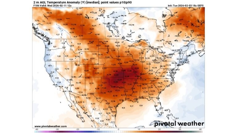
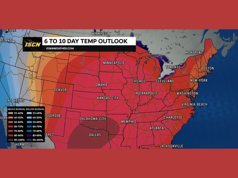
UNITED STATES — A strong mid-February warm signal is expanding across a large portion of the country, with the latest 6–10 day temperature outlook favoring above-normal temperatures across Iowa and much of the central and eastern United States through February 16–20.
Iowa Sits in the Core of the Above-Normal Temperature Signal
The outlook highlights Iowa squarely within the strongest warm shading, reinforcing the idea that the current mild stretch is not a brief break but part of a broader pattern likely to hold into next week. The forecast discussion tied to the outlook suggests highs in Iowa could remain in the upper 40s and 50s to finish this week and into the weekend, with more 50- and even 60-degree readings possible as the next week begins.
Warmth Extends From the Plains Into the Midwest, South, and East
The above-normal zone spreads well beyond Iowa, covering much of the central U.S. and Midwest, including areas around Minnesota, Nebraska, Kansas, Missouri, and Illinois, and continuing south into Oklahoma, Texas, Arkansas, Tennessee, Mississippi, Alabama, and Georgia.
It also stretches east into the Great Lakes and Ohio Valley—including areas around Chicago, Cleveland, and Indianapolis—and continues into the Mid-Atlantic and Northeast, including major corridors near Washington, New York, and Boston.
Carolinas Included as Milder Air Reaches the Southeast Coast
The map also places the Carolinas, including areas near Charlotte, within the above-normal temperature shading. That suggests the Southeast is also expected to hold onto a warmer-than-usual pattern during this 6–10 day window, consistent with a broader eastern U.S. ridge keeping mild air more established than typical for mid-February.
Pattern Driver: Western Trough, Eastern Ridge
The discussion tied to the outlook points to a classic setup: a deep trough over the western U.S. paired with a strong ridge over the East. This configuration often supports repeated surges of milder air across the central and eastern states, limiting how quickly winter cold can return.
While day-to-day swings are still possible, the overall pattern favors warmth holding its ground longer than usual.
What This Means Going Forward
This type of wide-area warmth signal doesn’t guarantee record highs everywhere, but it does raise the odds that many locations will average above normal over the period—especially across the central U.S., Midwest, South, and much of the East. It’s also a pattern that can influence storm tracks, sometimes shifting stronger systems into the Plains or along the northern edge of the warm dome.
CabarrusWeekly.com will continue tracking these pattern shifts and how they evolve for North Carolina and the broader eastern U.S. as the Feb. 16–20 window gets closer. Readers are encouraged to share how temperatures compare to a typical mid-February week in their area at CabarrusWeekly.com.