Stormy Valentine’s Day Ahead for Oklahoma: Severe Storm Risk Targets Southeast OK While OKC and Tulsa Face Elevated Wind and Hail Threat
OKLAHOMA — A dynamic storm system is set to bring widespread rain and thunderstorms across the state Friday night into Saturday, with the greatest severe weather threat focused over southeast Oklahoma.
Forecasters indicate that while much of the state will see rainfall and thunderstorms, storm intensity will vary significantly by region.
Heavy Rain and Statewide Storm Coverage Friday Night Into Saturday
Showers and thunderstorms are expected to expand across Oklahoma beginning Friday evening, continuing through Saturday afternoon and evening. Far western Oklahoma may see initial storm development Friday, with activity gradually spreading eastward overnight.
Rainfall coverage will be widespread, and multiple rounds of storms are possible. This setup suggests periods of heavy rain, lightning, and gusty winds across a large portion of the state.
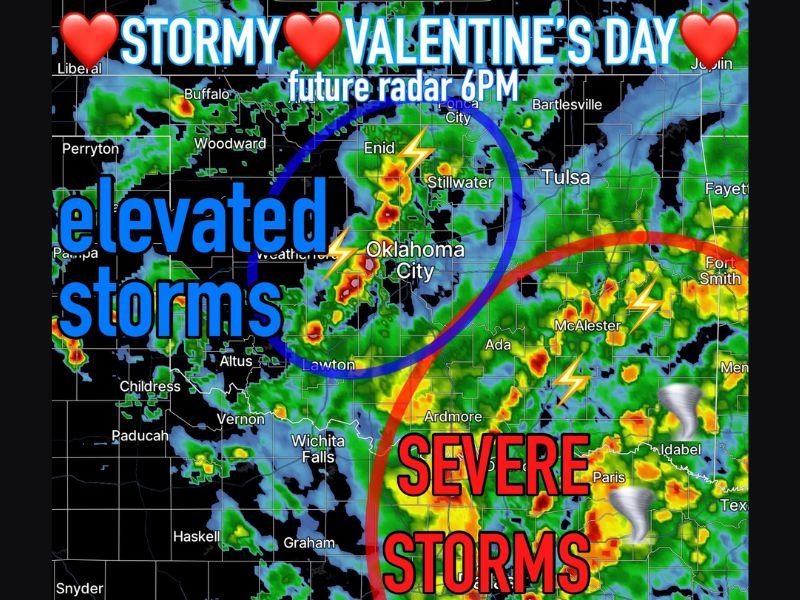
Southeast Oklahoma Faces the Strongest Severe Threat
The most concerning weather is projected for southeast Oklahoma, including areas near McAlester, Ada, Ardmore, and toward Idabel and the Arkansas border.
In this region, storms could reach severe limits, with the potential for:
• Damaging wind gusts
• Large hail
• A low but present tornado threat
While the tornado risk is not expected to be widespread, conditions in far southeast Oklahoma could briefly support rotating storms Saturday afternoon and evening if instability increases.
Elevated Storms Expected Around Oklahoma City and Tulsa
Further north, including the Oklahoma City metro, Enid, Stillwater, and Tulsa, storms are expected to be more elevated in nature. Elevated storms typically produce hail and strong winds, but are less likely to generate tornadoes.
Forecast guidance suggests that while some storms could approach severe criteria, impacts in central and northeastern Oklahoma should be more limited compared to the southeast.
Timing and Valentine’s Day Impacts
The most active period for severe potential appears to be Saturday afternoon into Saturday evening, particularly across southeast Oklahoma. Friday night activity may primarily consist of rain and embedded thunderstorms.
Residents with Valentine’s Day weekend plans should stay weather-aware, especially in the southeastern part of the state where storm intensity may peak.
Bottom Line
This will be a stormy Valentine’s Day weekend for Oklahoma, with heavy rain statewide and the strongest severe threat focused over the southeast portion of the state. Central and northeastern areas, including OKC and Tulsa, should monitor for gusty storms capable of hail.
As the system evolves, forecast details regarding storm intensity and tornado potential may change. Stay tuned for updates and be prepared to adjust plans if warnings are issued. If you are experiencing storms in your area, share your local conditions with us at CabarrusWeekly.com.